Pegasus Caving Club
aka Pegasus Club Nottingham
6th October Poulfantaiseach
CC, PC
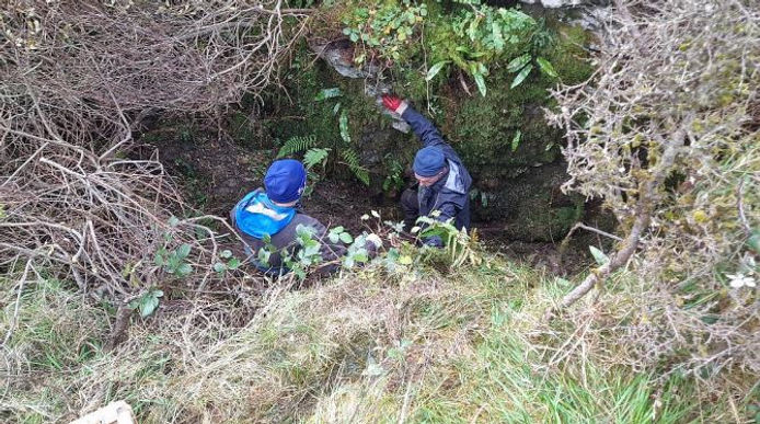
14:00. Cloud 100%, base 900ft: Wind S, F5/6: Visibility 15Nm: Ground sodden: Rain gauge, (after five days) 54mm. The Plan: continue preparing for permanent shoring. Carried up a short length of scaffold plus normal assorted tools etc. Quite a lot of water cascading into the rift from both ends. Minor phaffing finishing the last two horizontal stemples; second from the top needs tightening with a narrow spanner. The mesh can be fitted in four sections. Starting its installation at the bottom will allow the partly filled entrance passage spoil to be backpacked behind said mesh and plastic boarding, to hold any porridge in place. Reviewed the point of entry to the passage, the source of debris originating from the “north” wall. This needs stabilizing. It will be possible to clear the debris accumulated at the beginning of the crawl and also pack this behind the forthcoming permanent shoring requiring a short haul. Photos taken.
Hours 4 (68)
Pat Cronin

Permanent Shoring Shaft Side

Area between Temporary and permanent shoring
9th October Poulfantaiseach
PC
14:30. Cloud 5%: Wind S, F2: Visibility 20Nm: Ground wet: Trickle from both streams: Gauge 0mm: Temp >20°C. The Plan: install steel mesh behind stemples. Plodded up with Hilti drill, Boycotts grinder, assorted tools, two pieces of reinforcing mesh and four plastic posters, for placing behind the mesh to stop the porridge flowing through. A fiddle, from start to finish; phaffing about, trying to insert the mesh behind the lower stemples. The mini grinder a joy, enabling cutting the mesh to fit the wall undulations. As the lowest stemple has a span of two metres, installed a 16mm support bolt, reducing the span to ≈one metre. Used heavy duty cable ties to secure 6mm mesh in position. Eventually completed task, alas the Hilti battery died; thought it was charged? Twat. There remains the half dozen twelve millimetre holes to be drilled and 12mm rebar supports inserted, upon which pieces of shale can be placed, upon which the shoring can be back filled with the accumulated debris in the entrance passage and “Waiting Room”. Then, and only then, can the area directly above the entrance passage be considered secure to work beyond. LS likely to be about the 16th Oct, so want to have the shoring ready to back fill by then.
Hours 2 (70)
Pat Cronin
14th October Poulfantaiseach
PC
10:40. Cloud 20%: Wind NW, F4, chill: Visibility 15Nm: Ground wet: Both streams a trickle: Rain Gauge 2mm: The Plan: complete 12mm holes for stonework base, behind shoring. Took along drill, Boycott’s grinder, tools, drill bits, two metres of rebar and a narrow section of reinforcing mesh. Managed three 12mm hole before drill began to act up; no hammer action, played with it, but no go. Then the battery died. Fitted rebar and began to lay/insert stonework behind mesh, up to almost 200mm height; the thin shale an easy material to lay. Drew some stone from the entrance passage. Tried drill again, unit worked but issues from gear box; new unit required; bugger. Ideally a vertical support bar need be fitted the western end of the lower shoring. Two of the three temporary shoring, vertical fence posts are loose, so can be recovered the fence post in the bedding is now on the surface, (three spare posts).
Hours 2 (72).
Pat Cronin
16th October Poulfantaiseach
PMcG, LS, PC
13:00. Cloud 20%: Wind NE, F2, chill: Visibility 30Nm: Ground wet: Each stream a trickle: Rain Gauge 1mm: The Plan: complete shoring framework/clear debris. Using the old Hilti drill quite successfully, PC installed the final vertical rebar support, fixed mesh to support the debris filled rift and two 12mm holes below the upper shoring to enclose a lower exposed area. The refurb’d battery did good, considering its previous performance. Meanwhile LS to the “Waiting Room”, pressing along the crawl reaching an estimated 24m, where the passage turns and minor digging is required to pass. All then focused on building stonework to establish a sound base of the shoring. The area or cavity, behind the western end of the shoring, (from whence a chunk fell out), was back packed, to support the suspect, hanging mass above; mostly completed. PC to “the “Waiting Room” to assess debris; employed the small diameter No. I kibble, LS in the entrance passage, PMcG above, kibble swiftly moved. Spoil placed into the area behind the new shoring, at surface. Significant debris removed exposing part of the eastern wall, and undulations, nice. Stopped because the spoil area was brim full, PC entered the bedding clearing loose bits to either side, above suspected flood levels. Owing to a painful hand, turned and headed out. Noting, in the roof, the narrow, water worn rift meanders tightly, almost forming “horseshoes”. Beneath, the crawl follows a much straighter route, with estimated angles around 30°. The passage appears formed as a rift. Where debris has partly filled, so the stream has formed the crawl. A trench should exist below the compacted floor debris. The slope of the crawl is surprising, quite pronounced; maybe somewhere between 5/10°, so little chance of ponding during any required digging. PMcG to the end confirming LS observations. A cracking session. Heavy rain expect tomorrow during Storm Babet.
Hours 12 (84)
Pat Cronin
18th October Lost Michael, (Grease Can), Considine
Michael was the landowner where Considine's Cave dig is situated. In the seven years we were digging he never visited the site, his only comments being "dig away lads, dig away".
_JPG.jpg)
21st October Poulfantaiseach
PMcG, PC
10:00. Cloud 75%, increasing: Wind N, F4, chill: Visibility 20Nm: Ground sodden: Rain Gauge 1mm. The Plan: dig the next minor obstruction. Serious surface evidence of water flow, partial collapse of the area above the upper shoring, minor slumping of the contents of the temporary shoring, such has arrived where PC had previously packed stone to accommodate this inevitable event. PMcG in front, PC in rear. As PMcG dug the debris obstacle, PC packed loose debris from the streamway, into every nook and cranny. Both swiftly soaked by the trickles and small stream. PMcG and his concave chest was swiftly through. PC remained digging at the debris to facilitate a real chest. Once through, found PMcG had passed an awkward bend, with protruding flake. To comfortably negotiate “Cadbury Corner” will require a chunk of it being removed. Four metres beyond, at the next bend, PMcG continued digging debris and packing it away to progress. Here the development assumes a minor trench in the floor. Whilst PMcG enjoyed himself, PC backed out to the “Waiting Room” attempt make a sketch survey with bearings; a partial disaster, issues being fogged spectacles, crap note book, repeated shite on compass prism. PMcG reached a point where, the crawl is morphing into a rift, though some 0.3m metres wide, it is increasing in height, what appears an inlet, (a soil slope), is on the left, perhaps some three metres high. PC scrutinized the room available to pack debris: little enough. Both returned to surface, chilled. Spent time inserting more stone to reduce chances of the slumping spoil squeezing out; that done, the plastic sheet can be deployed and debris filling packed behind. A brief assessment of the data suggests strong, joint controlled development. To PMcG’s for debrief, tea and soup. The next plan is based around reducing spoil room. It appears that the rift is free of debris, the issue, how some of the Teams chests can reach this point. A fair amount of debris is deposited the first bend, by nature and man, this can be removed to outside, reasonably easily. Freeing the area for turning around, and stacking tools out of the stream to work on the Flake at “Cadbury Corner”. Any debris beyond this can then be put into “Sandbags”, several to be stacked at the cleared area. PMcG can see for a further three metres along the rift. Fine draught today.
Hours 4 (88 )
Pat Cronin

Rough Sketch of Poulfantaiseach

Entrance passage

Lower part of shoring behind steel mesh
23rd October Poulfantaiseach – Poulbruíon – MQ00-MQ01-MQ02-MQ03/3a.
PMcG, PC
14:00. Cloud 100%: Wind E, F4; cold: Visibility 15Nm: Ground awash: Rain Gauge (9mm overnight), (between 09:00 and 13:00, 7mm rainfall). The Plan: assess after morning rainfall. En-route PMcG checked Pluais Gabhar; significant flow noted in the hole located some three metres before the actual entrance. Inside, at the base of the excavated rift, no flow was evident in the pool; though this may be because the stream course has changed during previous digging of the soft streambed debris. This needs checking. Mounting the upper terrace, (elevation 270m), significant water flow was heard. Decided check north to south. At sink MQ00, a large stream tumbled into the reed choked area. MQ01, a large stream was heard; likely that as at MQ00. MQ02,small stream heard. MQ03/MQ3a, large stream witnessed, likely from MQ00 and MQ01. Halliday’s Hole, (MQ04), large stream. Poulfantaiseach, (MQ05), a decent stream issuing from the obscured gulley, in concern to this volume, water was flowing from the east slope, also emerging from a small conduit at the overburden/limestone boundary. Thoughts turned to Poulbruíon, an alternate dig, should winter rains delay removing the three obstacles within Poulfantaiseach. Autumn denuding the foliage, clearer view of the walls; it is a rift, a shaft. Poking about in the fill PMcG noted the west wall fluting descending a further two feet, below the floor, the east wall seemingly undercut. From below the sound of falling water. Spoke of wanting to open this site for a while; the present situation in Poulfantaiseach, needs a thin chested Jim or Cathal, to support PMcG to press on along the open rift, ideally before too long. The work required relates to the frustrated Plumber.
Pat Cronin

28th October Poulbruíon
PC
15:00. Cloud 60%: Wind SE, F4: Visibility 30Nm: Ground wet: Rain Gauge 3mm. The Plan: assess site requirements. Previously unrecorded, discovered 21st August 2023. Spoke earlier with MQ, requesting permission; enthusiastically instructed to “Work Away”; MQ accurately described this sites precise location and spoke of a “sizable” hole in the bottom. Descended, confirmed PMcG’s observations. Dug the central area adjacent an obvious two foot deep hole; between both vertical rift faces; no sound of water today. At a depth of only six inches found extensive root system. Need loppers, secateurs, pruning saw and a hauling system. The soil is of clay and silts, each appear fine grained. Grey coloured clay found just beneath the brown soil cover, similar to that seen in Poulfantaiseach. A simple scaffold platform spanning the rift would facilitate hauling, the spoil scattered evenly over the landscape using the wheel barrow. Fencing the site is straightforward enough; two limestone terraces will take rawlbolts to strain wire between, supported by four fence posts. However, the west side will require locating grykes in which to secure fence posts. Have barbed wire. When showers cleared, descended west, downhill, to the Drovers Road; enroute remembered another site; found it, a developing collapse; fifteen metres from the boundary wall and seventy metres from the Drover’s Road. As winter storms approach intend develop this site, particularly if Poulfantaiseach becomes too wet in which to function and deploy a Hilti drill, as occasional snugness of Poulfantaiseach requires engineering a little more space for PC’s chest to pass through.
Pat Cronin

Poulbruion bushes centre image. View west

Poulbruion beneath the bushes View northeast
3rd November Poulbruíon
CC, PMcG, PC
13:30. Cloud 95%: Wind SW, F4: Visibility 20 Nm: Ground wet: Light showers: Rain Gauge 4mm. The Plan: prepare dig. Ancient roots, as thick as an arm, obstructing the dig area, were eventually removed using saws and loppers, taking most of the Team’s time on site. The walls assessed for stemple installation. With the large roots gone, discussion agreed best practice was to excavate a “vertical step” some two feet deep, at the southern end. Then install a stemple at the lowest practicable position for the shoring. Above this install a second stemple, behind which fit reinforcing mesh and boarding to secure spoil behind. Doing this will allow spoil to be cast over the shoring without hauling. The intended spoil area, behind the southern shoring could potentially hold six cubic metres. Heavy rain threatened tonight.
Hours 6, (6).
Pat Cronin
Pat Cronin & Paul McGrath at Poulbruion after the bushes were cut back
13th November Poulbruíon
PMcG & PC
14:00. Cloud 100%: Wind W, F7/8; remnants Storm Debi): Visibility 15Nm: Ground sodden: Rain gauge since 09:00, the 10th = 38mm (most, seemingly from the storm). The Plan: dig. Very short notice to the Team. Windswept ascent; sea conditions very rough. Created a vertical face in the southwest end of the rift floor. To the depth of another 750mm, can now install the lower of the three shoring stemples for the southwest side. Once stabilized, can deal with the northeast side; spoil initially deposited onto the south area. Ideally repeating the same to the northeast. Avoiding as little hauling to the surface, and dumping, as possible. Depth exposed a change of the upper soil strata to a grey clay deposit, just above several angular boulders, resting upon other stone and possible gravel deposits. Ready for shoring.
Hours 3, (9).
Pat Cronin
18th November Considines Cave, South End
CC, PMcG, PC
10:00. Cloud 100%: Wind W, F5/6: Visibility 20Nm: Ground awash: large stream: Rain gauge 19mm. The Plan: Remove fixed ladders below “The Staging”. Arrived to find the canopy ripped apart by Storm Debi, also had issues with the breaking system of the winch; ably sorted by CC. CC on the winch and surface support. PMcG support from the staging. PC to the bottom of the ladders. A slow process, removing the bolts and fixings, conducted from a sit harness attached to the ladder rungs, resulting with crimped balls. Gradually got a feel for what could be undone and where to do it. Solo, CC managed to “land” the shorter ladders, for the long ladder, PC surfaced to assist landing this heavy unit; the holes in the canopy meant, by using cow tails and the winch rope the five metre ladder was guided through a handy hole in the roof and lowered to the working platform, which is swiftly deteriorating. Four hours of dangling and hard effort by the Team managed to land the two short and one long ladders. A tough session. The stemples below the staging will be removed Monday afternoon. Experience suggests rebar steps be fitted adjacent the ladder joints, off which to work in a more safe and stable manner. Need arrange a trailer and a tractor to remove forthcoming material and equipment.
Hours 13 (3405), Southend (2353), Kibbles 0 (6754), Nets 0 (929), Total lifts 7691
Pat Cronin
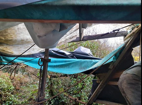
The destroyed canopy, all thanks to storm Debi

The bottom 3 ladders at surface, 5 more to go
20th November Considines Cave, South End
CC, PMcG, PC
13:00. Cloud 90%: Wind NW, F4/5: Visibility 15Nm: Ground awash: large stream: Rain gauge 4mm. The Plan: continue removing infrastructure. Set up an SRT rope off the Tripod; PMcG to the bottom to recover the rebar steps from -22m to -25m, then ascending to remove the stemples up to the level of the ”Staging”. Meanwhile, CC and PC cleared accumulated digging detritus. PC then descended to assess installing “Rebar Steps” adjacent the remaining ladder joints, to work more safely and easily. However, the dam Hilti acted up again, no hammer action, again; somewhat pissed off. To complete todays tasks, inserted a scaffold bar to secure an SRT rope to when removing remaining stemples. There appears to be one long and four shorter ladders remaining. Plan visit next Friday to install steps and begin releasing fixings. CC had begun to carry up some of the plastic kibbles to the trucks. Fortunately a pal was preparing a trailer of recycling material; asked permission to load the kibbles and metal material. Grand.
Hours 10 (3415), Southend (2363), Kibbles 0 (6754), Nets 0 (929), Total lifts 7691
Pat Cronin
24th November Considines Cave, South End
CC, PMcG, PC
13:00. Cloud 10%: Wind NW, F3/4: Visibility 30Nm: Ground sodden: large stream: Rain gauge 3mm. The Plan: Further preparation for ladder removal. CC surface: PC below. Using cow tails secured to ladder rungs and lifeline PC stopped at the junction/joint of each fixed ladder. Estimating approximate position to drill 14mm holes to insert 12mm rebar “steps” on which to stand in SRT kit to dismantle the ladder fixings. Descended with the Hilti and spare battery in a tackle sac, a mistake. The weight an issue getting into position, and drilling. This replacement Hilti is quite superb; delighted at it and the batteries performance. Right hand an issue, finished drilling, ascended. CC had been busy stripping ancillary items and bits off anything that didn’t move. Figured out a way of removing the topmost, longest, heaviest ladder by incorporating a hauling line deviation to lift it to surface. Carried up several more bits to the truck, more discussion over transporting the ladders, which will total two long and seven short. Touched on hauling at Poulbruíon, will likely install a tripod to accommodate lifting kibbles and tipping spoil either side of the scaffold frame shoring. Hope to remove ladders Monday afternoon.
Hours 5 (3420), Southend (2368), Kibbles 0 (6754), Nets 0 (929), Total lifts 7691
Pat Cronin
27th November Considine’s South End
CC, PMcG, PC
13:00. Cloud 60%: Wind N, F2/3: Visibility >35Nm: Ground sodden: Stream medium: Rain gauge 7mm. The Plan: remove ladders above staging. CC winching: PMcG below: PC surface. PMcG, descended on SRT and began work; a herculean task, wresting often corroded bolts from timber and stemple securing. The temporary rebar steps were useful enabling PMcG to brace self, attempting undo the more difficult bolts. The five metre, topmost ladder remains. To remove this, part of the working platform will be removed to lift it vertically to surface. Several stemples came out attached to ladders, the remainder await removal. Managed to convey three ladders up to the back of the Landowners house, ready for transportation.
Hours 9 (3429), Southend (2377), Kibbles 0 (6754), Nets 0 (929), Total lifts 7691
Pat Cronin
1st December Considine’s Cave, South End.
CC, PC
13:00. Cloud 70%: Wind E, F1: Visibility >35Nm: Ground wet: Stream small: Rain gauge 0mm. The Plan: remove final ladder. PMcG previously released the stemple securing the lower part of the top ladder. Re-located the lifting pulley along the main canopy spar, directly above the ladder, only then able to remove the platform pallet to release the ladder’s topmost fixings. CC on winch, PC climbed down onto the scaffold frame he’d fitted in 2020. All ladder fixings came apart swiftly. Attached the hauling hook and lifted the ladder up; the process was repeated three times, as ladder length was five metres. Result; ladder out in less than twenty minutes. Stripped apart the hauling line and lifeline, recovered the SRT rope. Will bring a decent SRT rope Monday and suspend it from a scaffold bar on the surface. Several stemples remain which PMcG can remove Monday. Staging remains, a useful access through the narrow rift into the North End shaft. Electrics and winch can be removed. Will also recover the generator; left the sack trucks there for this purpose.
Hours 5 (3434), Southend (2382), Kibbles 0 (6754), Nets 0 (929), Total lifts 7691
Pat Cronin

Pallett removed to give access to the topmost ladder for removal

Ladder safely supported whilst re-positioning the winch rope for the next lift

The last of the 8 ladders safely at surface having the short stemple removed.
4th December Considine’s Cave
CC, PMcG, PC
13:00. Cloud 5%: Wind NW, F3/4: Cold: Visibility >25Nm: Ground wet: Stream small: Rain gauge 5mm. The Plan: continue removing infrastructure. PMcG to below, stripping remaining stemples; whilst below visited the North End via the squeeze from the South End emerging beneath “The Pinch”. CC removed electrical circuitry and began dismantling the winch. PC cut the five metre ladders in half, ready for future usage, and ease of handling, also recovered the water system from the cistern in the field to the reservoirs at the dig. Removed the Teams generator. Over several trips apiece, carried up to the truck a lot of kit, including ladders, boxes of ironmongery and hose pipes. An excellent session; thoroughly shagged out, but delighted.
Hours 7 (3441), Southend (2389), Kibbles 0 (6754), Nets 0 (929), Total lifts 7691
Pat Cronin
11th December Considine’s Cave.
LS, CC, PC
13:00. Cloud 100%, base 1000ft: Wind NE, F3/4: Chill: Visibility 10Nm: Pissing Down: Ground and Men sodden: Large stream: Rain gauge, 26mm; (09:00 Friday to 09:00 today). The Plan: continue to strip infrastructure. LS in support. CC began dismantling the winch. PC climbed down onto the scaffold frame to install/secure another two, two metre bars to the grill to cover the gap from whence the fixed ladder was removed. An estimated 3.5 metres of open rift will remain to cover with the grill when the infrastructure is removed. Carried the three remaining ladders, (Heavy), Winch main chassis, (fairly heavy), winch drive/gearbox/capstan chassis motor, (quite heavy), winch motor (effing ‘eavy) up to the parking area, need organize a trailer ASAP. A fine, productive session, only achieved with the help of LS: nice.
Hours 7 (3448), Southend (2396), Kibbles 0 (6754), Nets 0 (929), Total lifts 7691
Pat Cronin
21st December Pluais Gabhar
PC
14:00. Cloud 100%: Wind NW, F8/9: Visibility 2Nm: Ground wet. The Plan: design a process to survey the Axe in situ. Its situation, the far side of the narrow rift, means taking any kind of measurement will be awkward. Fixing a base line tape into the gravel matrix, above and behind the Axe will be unsatisfactory. Intend cover the Axe with a dust sheet, drill a datum into the natural limestone roof, directly above the Axe. Will then drop a plumbline from the datum to the centre of the Axe. Next, can confidently, also secure the baseline tape to this fixing, (cup hook?), through the entrance, to a hand tree outside. Using laser levels resting on the adjacent ledge can record multiple Axe context profiles, including the rift, which is a barrier/feature between where the axe was placed and the actual entrance. Ideally need a recorder, (Scribe).
Pat Cronin
23rd December Pluais Gabhar
PC
13:00 Cloud 100%, base 300ft: Rain: Wind S/SW, F7/8: Visibility 20 metres: Ground sodden. Rain gauge 3mm: The Plan; establish survey datums. Deployed plumbline to establish precise roof datum, centring off the middle, leading edge of the axe, the main portion just beneath the adjacent boulder. Managed insert a base line peg into compacted course gravel, 0.1m past the axe; being zero metres on the base line. Extended baseline to boulder at the entrance. Commenced survey. Confined within the rift, at the base of the wet, muddy entrance slope, repeatedly exchanging measuring equipment to record data in notebook. The latter suffered from migrating mud and myriad roof drips. Stifled frustration; managed record the minimum, but important measurements. As previously suspected, a scribe is needed to avoid water and mud transference. Confident had established the precise axe location, removed same to submit to the National Museum: somewhat relieved to have finally done so. Surfaced into visibility of less than three metres with rain blown by gale force winds. No navigation issues returning to the Hilux. However, cattle have created ankle wrecking craters all along the normal paths. Called to Niamh MacNamara requesting her assistance as scribe; agreed for 14:00, the 27th.
Pat Cronin

View North. Plumb bob centre of leading edge of axe

View North. The ledge where the axe was located with the crevice accessing the stream below
30th December Poulbruíon
PC
13:00. Cloud 70%; Rain – Hail showers: Wind SW, backing easterly, F5/6: Visibility 2Nm: Ground sodden: Rain Gauge 18mm: The Plan; get some actual digging in. En-route, looked for a better place to cross the wall. Followed the boundary wall east, uphill, onto the same terrace as Poulbruíon. Where it drops into the gulley, which flows to Poulballyelly, here wall is low, step-able, even for the most shortest of legs. No movement of the wall exposed, 13th Nov. All appears stable, even though the slope’s surface has been washed: rain or surface water flow? As previously experience the surface of the fill is slippery; stability of stance an issue when pivoting to throw spoil. Resorted to clearing a filled spade then throwing the lumps up the less steep gulley to the northeast. Encountered small stones and assorted roots. Managed some ninety minutes before having enough. Left a reasonable hole. Found the east wall continues vertically downwards, with what appears to be a vertical joint? Excellent. Pressed ear into the hole, at base of the west wall; convinced could hear a more substantial flow of water than previous, sounding as though it was falling a distance: echo imagined. Wishful thinking? Exited, into dense, dark cloud, and hail storm. Visibility reduced to twenty metres, cloud base, well below the Drover’s Road. Driving back encountered an American; male, 30-ish. Offered lift, declined, as walking to Doolin. 1.5, (10.5).
Pat Cronin
31st December Poulfantaiseach - Halliday’s Hole – Poulbruíon; Sliabh Eilbhe
PC
11:00. Last of the Year: Cloud 95%, base 700ft: Heavy showers: Wind NW, F6, gusting F8: Visibility 10Nm: Ground water logged/flooded: Rain Gauge 19mm: The Plan: assess recent rain effect. Since the 24th, 134mm of rain and hail has fallen. Wandered the wider project area, around the sites. Poulfantaiseach, taking a good sized stream, as was Halliday’s Hole and each adjacent sink. At Poulbruíon; listened at the little hole. As yesterday, strong surface wind noise did not permit a clear estimate of running water below. In adjacent gulleys, deep and shallow, at 250m OD, were small streams flowing through the pastures, toward the project’s main area of interest. The small collapse, fifty metres upstream of Poulballyelly, was taking a trickle. The area, north of Pluais Gabhar, best guessed vicinity for Pollapooka II and A1e, was entirely water logged. Stream noise from the shaft of Pollapooka, delightfully thunderous; believed the stream from the small sink, feeding the Holy Well of Toberanahircallough, via Pollantobar, via E1 sink, via many depressions to the final, deep, (partially backfilled) depression, ten metres south of Pollapooka; the opposite side of the rough track. Noted a large stream flowing through Toberanahircallough. Walking - observation, challenging in rain and hail; showers occurring every ten minutes. Would have been drier to lay in the pools. En-route, there and back, noted that any hollow in every field held a pool; roads had standing water in every possible hollow.
Pat Cronin