Pegasus Caving Club
aka Pegasus Club Nottingham
1st January Gragen West Cave, Poulacapple
TB and PC
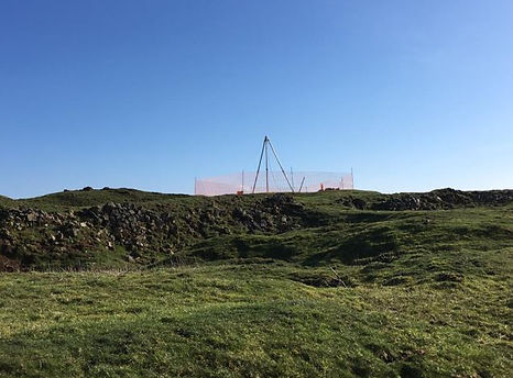
Overcast: mild: no wind. The forthcoming U.B.S.S publication required clarification of location of several entrances. This cave has four, obscured by terrain and inherent error issues within the Irish National Grid (1965). Todays aim was to establish their true location and record these entrances as Irish Transverse Mercator; I.T.M will shortly replace the old INGR (1965), (confirmed with Irish Ordinance Survey field operatives). TB had previously sought the Main Entrance and found it to be one of two possible sites. Today the actual entrance was identified, from compass bearings and GPS to indicate actual distance measured from the main entrance, Top entrance was judged to be identified as the adjacent Green Groove Cave and the vicinity of Green Stream Cave, further to the north. Since the previous trip, (June 2005) vegetation growth has confused/camouflaged the entrances appearance. The deep depression thought to be Top entrance requires descending to confirm its ID. Adjacent this presumed entrance is another, entered by TB in gear to a squeeze in limonite at floor/stream level; it did not appear to be the one exited in 2005; will check this shortly.
Top Entrance; 0519190 x 0703294 (to be double checked) (See log for 4th January 2019)
Main Entrance; 0519281 x 0702892
To the Roadside, for a cool libation.
2nd January Boxhead Pot to Ground Sheet Junction to Notts 2 and Iron Kiln
Simon Halliday, Aaron Smith and Jason Denley
After returning a Titan suit to Bull Pot Farm, we met at Inglesport Cafe at 930am. Various breakfasts were consumed and plans were finalised. Off to Leck Fell and an expected 8-10hr trip. Si rigged the entrance tube and first pitch (40m ish) in good time and all 3 off us were soon at the second huge drop. (100m ish). The second pitch can be rigged directly to the bottom but we needed to exit 15m from the end and swing over to the Kendal Extension and into a crawl that linked with Tate galleries. Si swung into the opposite side of the main shaft and found it anchor free and unfamiliar!
(....'Aaron! ..i can't find any rebelays in this rift!) I came down to see and we both realised we had a huge pendulum to do so that we could rig our rope in the opposite side of the main shaft. Excellent team work just seemed to come together at the right time and in minutes we were back on track and sliding down into Tate Gallery... Crawling; holes in the floor; the Cresta Run; flat out crawl in water; difficult navigstion; a 30ft climb up a muddy chimney.... then we were in Lyle Cavern Upper Series!! .... some food here (2hr in) and a 30min explore of the way on to Ground Sheet Junction. We had planned to abseils down 5 Pitches and return up the Lyle Cavern pitch. (A simple pull through was not going to work here so we changed our plan). Plan B .... Off to Ground Sheet Junction down Lyle Cavern.. great formations everywhere! We had a reccy to the base of the Lost Johns final pitch and the back up into Lyle Cavern Upper Series. ... Next was the job of finding the was on to Notts 2, a 140m crawl/slither/climb, through tiny passages in mud and boulders. James Denley led the way and by luck or fortune or good sense we were soon in the right crawls. (I followed on behind and soon recognised the passages from the description in the guide). Lots of determination and we were soon in Bruno Kransies and Sir Digby Spodes passage and Notts 2 main streamway. A sing-song or two and before long we were ascending the iron kiln ladders and scaffolding. Out by 6pm! We had been underground for around 6 and a half hours! ... that wasn't all, another 1 and half hours of further caving for me and Si. We had to go and derig Boxhead! (That went smoothly). .. Off to the Marton Arms for a blonde ale, tea and chip butty. Excellent and very demanding trip. The most challenging trip I've done in over 10 years! Well done to all. 😁
Arron Smith

3rd January Considine’s Cave (South End)
TB, CC, PC, JW and CM
Great turnout for Thursday night, with the team obviously sticking to their New Years resolutions of: “more digging, faster!!”. No wind, mild, small stream. With CC winching, PC and JW above, CM and TB began digging. The area below the shaft was stacked with pre-filled kibbles from the previous session. Work focused on leveling the floor to the Southern end. It soon became noticeable that a crack line is visible in the southern corner. Changing the shape of the shafts south end from smooth oval to triangular, and flaring slightly outwards (South). More interestingly, to the left and right of the southern end (approximately at SSE and SSW positions) two openings appear to flare outwards heading east and west respectively. The east heading opening drops around 0.75m below the dig surface. The west heading opening around 2.5m vertically and under-hangs by 1m with respect to the wall. A draft was felt from both. Floor is now comprised of mainly small boulders and loose stones.
Hours 15 (1705), Southend (655), Kibbles 50 (2081), Nets 20 (404), Total (2485)
Cathal Mullane
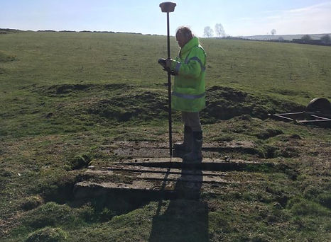
4th January Gragen West Cave and Area
TB and PC
60% cloud cover: Cool: ground wet. The plan: to revisit to identify the location of Top Entrance, Gragen West Cave, prior to copy date, 10th January, for the forthcoming U.B.S.S publication. Made straight for the previous northern cave entrance reached on the 1st January; descended same by climbing down through the thick undergrowth. This is a wonderful pot beset with beautiful features and a narrow passage leading off best passable at stream level. Though an enjoyable place this was confirmed as not being Top Entrance. Climbed out and moved with difficulty into the next hollow, en-route finding a little hole in the bole of a small tree; TB descended the two metre drop using a ladder into the top of a small chamber, like an oculus, and explored a crawling passages for some twenty metres, which continued. With only two hours of light left the pair decided to press on with the most important part of the project. After much wandering across this vast featureless landscape eventually located a gully on the eastern side of the shallow valley which generally runs north/south. Again a thrash through dense thicket dropped into a stream fed depression, downstream some ten metres was finally found the Top Entrance, wide open: recorded the site in ITM using two GPS receivers: adjacent sites also recorded: to the Roadside for well earned pints.
Top Entrance ITM 519159 x 703371
Main Entrance ITM 519281 x 702892
TB1 pot ITM 519176 x 703312
TB3 small pot ITM 519192 x 703310
TB4 ITM 519193 x 703319
016 ITM 519182 x 703327
Pat Cronin
5th January Considine’s Cave, (South End)
CC, TB and PC
Dark: Turning cooler: Small stream: The Plan: Dig. TB below, PC unloading and barrowing with CC winching. Thoughts turned to the time taken lifting kibbles to surface, which will increase further with depth: the team reflected and will not increase the speed of winching, (40 feet/minute). This present rate of lift allows larger rocks, suspended in the net, to be safely negotiated through the lower and upper shaft collars. TB continued the now normal procedure of excavating a one metre deep hole in the middle of the “Narrows” to create two working faces, out from which easily tumble the loosely compacted spoil, (hence the rate of digging). With the exposure of the “Fissures” TB focused on clearing away the south end, lowering the presently uneven floor level around a foot below that at the base of the hauling shaft. Of the forty kibbles raised seven were gravels, four of which were used as levelling material for the next section of dry stone walling to retain the expanding boulder pile; among the boulders lifted in the kibbles were some very large cobbles. Other kibble content was thrown up to further increase the height of the party wall with the northern field. Of the fourteen nets several contained huge boulders, at least one ≈120 kilograms for which a 2:1 was initially considered. Many of the large boulders were of a flatter shape useful for constructing the next section of retaining wall. The development of this neat and tidy spoil containment area will not only reduce the time and distance involved to swiftly disposed of the spoil on its arrival at surface, but also demonstrate to any passing observer, particularly local Farmers, the strange doings of a responsible group of individuals. CC brought down a large replacement battery for the comms and signaling system, which should serve the needs for quite some time: to the Roadside for cracking pints.
Hours 7 (1712), Southend (662), Kibbles 40 (2121), Nets 14 (418), Total (2539)
Pat Cronin
6th January Malham Cove
SH
In up Aire River Passage. Worked in the dig in asterisk passage trying to move a boulder. Whilst waiting for vis to clear I was ferrying scaff back from further in the cave.
Simon Halliday
7th January Considine’s Cave, (South End)
TB, CC
Dark: Mild: Large stream: Cool wind. The Plan: Dig. TB Below, CC winching PC unloading and barrowing. PC arrived early and brought down a beer keg as a seat for the winchman, which worked well significantly reducing strain on back and legs. Normal digging began with TB continuing to lower the southern end and part of the “Narrows” to further expose the recently uncovered east and West fissures. Even though quite mild outside, both fissures continued to draught though not as strongly as previously felt. Of the thirty three kibbles lifted seven were gravels, the remainder of the content thrown up onto the boulder pile to increase its height and length along the northern field boundary. Almost every one of the sixteen nets contained a big boulder most of the huge irregular ones manhandled to the far spoil area; the others to be used for walling; to the Roadside.
Hours 7 (1719), Southend (669), Kibbles 33 (2154), Nets 16 (434), Total (2588)
Pat Cronin
8th January Considine’s Cave, (South End)
TB and PC
Dusk: Mild: Overcast: Small stream. The Plan: Maintenance. In order to avoid delaying digging on Thursday evening PC opted to reposition, (lower), both shoring cable anchors today. The signal button was also relocated to a lower, more reachable location. Tasks completed, PC looked at the “Fissures”; the smaller, eastern one is presently choked with debris from digging. The western fissure is very much the larger, (at this level); a 30 odd kilo boulder was dragged away improved the view showing that two metres below the opening widens in the main rift wall to about ¾ metre; from the vertical rift wall the space retreats at least 0.6 metre. With recent fallen debris removed the assessment is that an adult could kneel in the present visible space, at the very least. The rear of the fissure takes a gentle bend left obscuring further view. At around -9m are the beginnings of a very thin calcite vein which enlarges steadily to at least -11m where it disappears below the digging floor surface. This western fissure and others in the south end all seem begin significant development between -9m and -11m; similar to those in the north end. To the Roadside for a very nice pint
Hours 3 (1722), Southend (672), Kibbles 0 (2154), Nets 0 (434), Total (2588)
Pat Cronin
9th January Submarine Stalagmite, Cliff Cave
Please refer to the Logs dated 4th & 19th June 2018 for the background to this entry.

Hi Jim,
I've now dated the stalagmite from Fanore. The base is 11,049 plus/minus 72 years and the top is 8115 plus/minus 25
years. All dates are years before 2018.
I've attached a slide showing the stalagmite in cross section and the two bracketing dates. The top age of 8,115 is interesting as it may indicate the time when sea-level rose through this elevation and stalagmite growth stopped?
Let me know what you think.
All the best,
Frank McDermott, University College Dublin
9th January Gragen West Cave
TB and PC
Further work to assist TB to precisely locate the other two entrances prior to the U.B.S.S copy date for the forthcoming new guide book. The estimated locations worked out reasonably accurate drawn from the 1955 survey data. Entrances listed from north to south; the surprize was Joyce’s Hole, a fifteen metre long rift/canyon taking a significant sized stream. Talk turned to doing a trip from Joyce’s to Top entrance. Drove up to Poulacapple Pot to double check its ITM, 518757 x 704086; taken overlooking the climb down: a large stream heard; extricated a grounded Hilux twice from deep pools created by turf cutting machinery: to the Roadside for a very nice pint.
Top Entrance ITM 519159 x 703371
Pigeon Hole ITM 519193 x 703150
Main Entrance ITM 519281 x 702892
Joyce’s Hole ITM 519359 x 702796
Poulacapple Pot ITM 518757 x 704086
10th January Considine’s Cave, (South End)
TB, CC and PC
Dark: Mild: Small stream: The Plan: Dig. Unfortunately the generator starter rope broke, so the session changed to unscheduled maintenance. Unprepared, while CC lubricated the receiver’s wheels and conducted minor service to the winch, TB descended and filled all the kibbles ready for the next dig session; PC completed the water supply to the wash tub and the wash-down cistern and their overflow pipes. Three kibbles rope handles were replaced; all are now of a uniform length which solves several issues for both winchman and below. To a deserted Roadside for a very nice pint
Hours 3 (1725), Southend (675), Kibbles 0 (2154), Nets 0 (434), Total (2588)
Pat Cronin

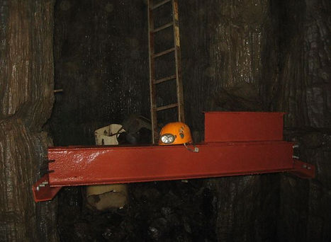
Cheg Chester in the cosy surrounds of the winchmans cabin at Considines Cave Dig. The blue drum rotates to temporarily store the hauling rope during each lift. Photo Cathal Mullane.
12th January Considine’s Cave, (South End)
CC, TB, CM, PC
Very dark: Wind F4, increasing: Dense mist: Small stream: The Plan: Dig. PC arrived half an hour late, delayed by a further Coast Guard callout, this time to Liscannor. CC winching, TB below, PC unloading and barrowing, meanwhile CM recorded events on camera for posterity. The character of the spoil removed has definitely changed to a greater percentage of larger rocks, clearly evidenced by the increasing number of heavy nets lifted containing said DBR’s, (Dam Big Rock’s), The large, lumpy ones, of no immediate use for wall building are deposited around the perimeter of the gravel and clay area. Fourteen nets were lifted, of the thirty eight kibbles raised five were gravels; a cracking session considering the delayed start. TB has lowered the area between the “Narrow” to the South End some three feet below floor level at the base of the Hauling way; this depth approaches -12m. Both water cisterns function well, as does the overflow pipes, thus avoiding excess water running down into the dig. The receiver now moves back and forth without any sense of weight or friction, this requires the regular use of the lock during unloading kibbles or nets. To the Roadside for a welcome drink.
Hours 9 (1734), Southend (684), Kibbles 38 (2192), Nets 14 (448), Total (2640)
Pat Cronin
14th January Considine’s Cave (South End)
TB, CC and PC
Dark: Drizzling: Wind West F3: Mild: Small Stream. The Plan: Dig. CC winching: TB digging: PC unloading and Barrowing. The team had set up by around 18:10, ready to commence. A steady pace raised fourteen nets and forty five kibbles of which four were gravels. TB is now clearing spoil from beneath the Hauling shaft; another session may see this achieved to form a level floor. The average floor depth was measured at -11.8m, (38 feet), which leaves a little under three metres to reach the “Plank” depth at -14.5m. The large lifting Karabiner was replaced by TB for a scaffold personal safety clip; a monster of a device but a very safe and secure device.
Hours 8 (1742), Southend (692), Kibbles 45 (2237), Nets 14 (462), Total (2699)
Pat Cronin
Photographs Below by Cathal Mullane
Showing the size of the shaft and the enormous task of emptying it

PC empties one of the 45 kibble of the evening, this one a single boulder
TB digging whilst a large Boulder in the net is winched to the surface
17th January Considine’s cave (South End)
TB, CC and PC
Dark: Thin cloud cover: Wind N, F3: Cold: Small stream. The Plan: Dig. TB below: CC winching PC unloading and barrowing. Normal procedures followed; digging, sorting rock, depositing said debris in allotted locations. After another session or two the northern boulder pile will require its retaining wall increased in height. This session produced forty five kibbles, of which five were gravels, and eleven nets. The session’s first kibble was the 2700th lifted from the southern end; hooray for the winch! The previous estimate of 20kgs per kibble is increasingly doubtful, they are most certainly heavier; scales required? With the drop in air temperature every orifice was draughting well……? Though the strongest issued from the western fissure found by CM; a clear view of its true nature presently remains elusive. As PC shortly departs for Panamá a strategy was decided for the next five sessions, TB will again create a pit in the “Narrows” and dig north toward the shoring, which immediately prior to departure PC will remove as many pieces as possible. This means maybe ten or so pieces remaining down to the “Plank”: to an empty Roadside for a superb pint and roaring fire.
Hours 8 (1750), Southend (700), Kibbles 45 (2282), Nets 11 (473), Total 2755
Pat Cronin
19th January Considine’s Cave (South End)
CC, TB and PC
Dark: Mild: Large stream: Clearing fog: The Plan: Dig. Prior to starting PC & TB descended to search for a tiny piece of camera equipment dropped by CM; alas no luck, PC did find a broken tripod leg some four inches long. Whilst at the “Plank PC counted the remaining pieces of shoring to be removed: 22. CC estimates that roughly, something like 300 – 350 kibbles worth lowers the floor of the dig by a metre. TB below: CC winching: PC unloading and barrowing. TB continued to remove the base of the Hauling way, up to and against the shoring so the pace tonight was a little slower. Of the forty kibbles raised eight were gravels, one containing a minor amount of the thick cream coloured clay hoped never to be seen, ever again; the twelve nets lifted contained some well rounded boulders. Gaps among the floor of boulders continue to appear. The western fissure exposed by CM on the 3rd Jan 2019 appears to pass behind a thin-ish curtain of limestone possibly linked at around -13m, to the descending, widening vertical rift that starts near the surface adjacent the shaft collar and continues below present dig floor level. The main boulder pile needs its retaining wall heightened; most of the larger boulders were set along the south side of the approach path as forthcoming wall building material. The piped route of the stream is almost ready for burying beneath the extended boulder pile. PC has located a possible replacement for the generator kindly loaned to the Team over a year by Matt Randall: to the Roadside for tasty drink.
Hours 7 (1757), Southend (707), Kibbles 40 (2322), Nets 12 (485), Total 2807
Pat Cronin
21st January Considine’s Cave (South End)
CC, TB and PC
Dark: Chill: Ground very wet: Sleet: Wind W F6 gusting 7: Large stream: The Plan: Dig. TB below: CC winching: PC unloading and barrowing. Vocal communications were an issue due to the noise of the streams in the pipework. By the end of the session TB had lowered the northern half of the floor some one metre below the Southern half exposing almost twelve pieces of shoring, producing forty kibbles and fourteen nets. The large boulders were placed along the path from JN’s field for inclusion in the forthcoming retaining wall; the six kibbles of gravels were used to improve the barrow run on to of a clay area. Closing down for the night CC discovered that cattle, probably MC’s, had pushed between the generator and the bushes, appearing to have stopped on the verge of the step down onto the platform. Attention to supplement the bush defenses required ASAP. To the Roadside.
Hours 7 (1764), Southend (714), Kibbles 40 (2362), Nets 14 (499), Total 2861
Pat Cronin
22nd January Considine’s Cave (South End)
TB & CC
An emergency site visit on a cold and damp morning to install a fence along the Eastern perimeter of the dig site. In daylight, the extent of the wanderings of cattle was quite alarming as they had almost circumnavigated the site but luckily had not picked up enough courage to walk on the platform itself. Fence completed, work was started on the extension to the retaining wall for the next area designated for a spoil heap. Pint as usual in the usual.
Hours 6 (1770), Southend (720), Kibbles 40 (2362), Nets 14 (499), Total 2861
Cheg Chester
24th January Considine’s Cave (South End)
CC, TB and PC
Dark: Cool: Mist/Fog: Ground very wet: good sized stream: The Plan: Dig. TB below: CC winching: PC unloading and barrowing. A minor delay meant lifting began at 18:30 even so forty kibbles and fourteen nets were swiftly lifted and processed by 20:30. TB lowered the hauling way floor further. Another possible hole or “fissure” may be appearing on the west side close to the shoring. Prior to departing for Panamá one idea arose that during the Saturday session TB lowers the floor against the shoring still further. Sunday PC removes all exposed shoring, repositions the two cable anchors, refits the “Gantry” and relocates the signaling button. It is possible that if fourteen sections of shoring could be removed it would leave seven of the seventy originally installed, in distance this would leave about a metre and a half above the “Plank”. The fixed ladder finishes at about this height above the “Plank”, from where rebar steps continue down, set into fourteen millimetre drilled holes for ease of removal to squeeze through to the north rift the far side of the ladder; this design meant the ladder would act as a brattice shielding the digger from falling debris during lifts. Later, in the Roadside, thoughts turned to a brattice in the much larger south rift, CC suggests a heavy plastic sheet, (curtain), deployed from the surface down the line of the Hauling Way secured at top and bottom.
Hours 7 (1777), Southend (727), Kibbles 40 (2402), Nets 14 (513), Total 2915.
Pat Cronin
26th January Considine’s Cave (South End)
CC and PC
Dusk: Cool: Wind, NW F7/8 gusting 9: Ground very wet: Good sized stream: The Plan: maintenance. As TB was incapacitated following the previous frenzied digging session the plan changed to removing the shoring and reset associated fixings. CC up top PC below. Thirteen sections of shoring removed leaving eight; the top of the shoring - present floor of the dig is almost level, now only five feet above the “Plank”; not counting the two cubic metre pile of debris waiting for removal in the far south end. The “Gantry was not refitted as there is now only a 0.7m gap between the ladder and the shoring, easy to step across. The end of the lowest fixed ladder is now just above the level of the shoring. The signal button was refixed one metre lower. Previously CM’s fissure was theorized as possibly connecting behind the face of the west rift wall with the adjacent tall, vertical fissure, they do, but, the base edge of the wall where it turns into the western rift ends as a large suspended lump, projecting about a metre. Whilst it looks safe questions arise of its overall integrity considering adjacent bedding joints; CC suggests a method of securing the suspect area which would slow any possible parting or collapse of these lower extremities. It remains to be seen what exacting happens below this level of floor debris; whether there is a place upon which may be set a support, or if the rift which heads off west does in fact develop to accessible size; questions, questions.... The regular noise of a freight train clearly heard at -12m was in fact the wind increasing strength; much damage sustained throughout the County: to the Roadside for a well earned pint and much digging talk. During a recent visit to Mark, (Gonzo), Lumley gifted his Hilti drill kit to a reluctant yet delighted PC; further to Barry Sudell making a minor repair to the charger, with battery charged, the drill was used to great effect tonight; Hilti Drills are a magnificent tool far superior to anything else used by PC. Thank you Mark.
Hours 5 (1782), Southend (732), Kibbles (2402), 1 Net (514), Total 2916.
Pat Cronin
27th January Titan
Aaron Smith (AS); Simon Halliday (SH); Mark Stubbs (MS, RRCPC); James Denley (JD, KCC); Sarah and David (SND, RRCPC); and Rhuarhri (Notts Uni).
We slept over at the TSG and shared a big breakfast, mostly prepared by AS, and for several pig us this was the highlight of the day! ... to be fair AS had a goodish day and SH had a terrible day! ... up to the cave for 10am and MS, JD, SND and R descended the ropes left in by the Combined Forces party the day before. SH was next to descend, rigging our rope as he went. AS was last in and leap frogged SH and went down to derig the army gear. (This was the first error as rigging and derigging 100m ropes is a terrible job!). When AS finally got to the bottom of the big pitch all of the others, except SH, were cold and ready to go out, they hadn't found the way on! ... SND headed out and AS took others under the boulders to the rest of the cave. Rhuarhri was next to head out and AS and MS went caving for 50 mins into the Titan streamway, JH connection and far sump extension. When they returned R was still ascending the big pitch. (This was a huge mistake as R was not as confident and competent at SRT as we had hoped). SH was so distressed by the lack of experienced cavers that he never left head of the big pitch! SH had been waiting at the top for over 3 hours while 4 cavers ascended the pitches. AS was next to ascend and discovered R was still at the Event Horizon waiting for instructions? Or something? The water levels had risen and MS and AS were very wet and very cold and stuck behind R. (He must have been even colder!!). After a further 45 mins hanging on our ropes R had cleared the pitch and AS let MS passed so he could exit next. Another 45 mins passed and AS ascended to meet SH and derig! Everyone else had buggered off. SH and AS derigged and carried all the gear... 3 bags each ... into an icy cold evening. All others had gone when we returned to our car and van. SH ended his horrific day with the wind taking his van door out of his hands and ending with a huge dent in it! .... two of the lads were waiting for us at TSG and we went off to the pub for hot drinks and a warm. A terrible trip overall, but AS did manage to explore a new bit of cave down to the far sump extension.
Arron Smith
28th January Considine’s Cave (South End)
CC, TB & PC
Dusk; Cool turning chill: Wind NW F4: Ground very wet: Small stream: The Plan: Dig. TB below: CC winching: PC unloading and barrowing. The first kibble lifted drew up the pile of assorted pieces of timber once used during installing the shoring, of the other forty four six were gravels, this material has been laid to create a decent barrow way across the mud surface of the far spoil dump, around the perimeter of which most of the forty and fifty kilo boulders raised tonight were deposited. The smaller stones and cobbles raised were used as packing behind the new section of retaining dry stone wall ready for raising its level. From among the sixteen nets several boulders of around eighty kilos a piece were lain alongside the path through the copse from Jonathon’s field. A cracking session considering the time used hauling up from -12m. TB managed to clear the majority of the large debris slope remaining at the south end. To the Roadside: sculling pints near the fire discussion of how best to deal with the overhanging tonnage of limestone considered various options based on what could be assessed at this moment. However, it slowly became apparent that individual observations made over the last three sessions did not quite tally. In short, TB left the site, (24th Jan) where he could not see the beneath the protruding limestone into the narrow rift joint behind it, during the next session, (26th Jan), PC and CC noted the gap of some 0.3m beneath said projection and into the rift behind. Tonight the gap was assessed as 0.6m. The subsequent lull in conversation, whilst the implications were considered, ended with the realization the floor may actually be subsiding. The provision of a lifeline for the digger was swiftly raised. This narrow western heading rift does look like it may widen further down and develop into an enterable passage. Options for dealing with this possible safety issue will be settled after closer inspection of the surrounding integrity of the suspect lump. Winter weather approaches; possible delays in departing Dublin for Panamá.
Hours 8 (1790), Southend (740), 45 Kibbles (2447), 16 Nets (530), Total 2977.
Pat Cronin
1st February Considine's Cave (South End)
TB & CC
Bright and sunny but the temperature well below freezing causing parts of the platform to be like a skating rink, on real ice instead of mud. The plan to re-assess the safety of the large hanging limestone pendant on the West wall. No further automatic lowering of the floor was observed and a decision to go ahead with pinning the blocks together with steel straps was agreed. All the kibbles were filled in readiness for the next digging session. Work then commenced on further construction of the retaining wall along the North side of the site.
A short video of no outstanding quality was taken to help you better understand the layout of the site and some of the descriptions in previous logs. Click on the link above to view.
Hours 7 (1797), Southend (747), 0 Kibbles (2447), 0 Nets (530), Total 2977.
Cheg Chester

Plenty of space behind the wall on the left to bring the spoil to a height seen on the skyline at right.
4th February Considine's Cave (South End)
TB & CC
Bright, sunny & warmer; Spring is here!? Generator problems delayed starting, the petrol on/off tap is leaking fast when turned off - nearly a gallon in 3 days, and slow when turned on, not easily fixable, hope the new one is available soon. Solved temporarily by raising the left side of the generator 6" when leaving the site. Remote pulley system devised for opening/ closing the trap for one man operation above worked well.
TB below, now relatively level to the South End, holes appearing around most edges investigated & drafting well, lots of spoil dropping away, but no more visibility downwards. 30 Kibbles & 1 net raised, several net loads of boulders left below.
Plan next session is to trench the west wall from the shoring to the middle rift to assess how unstable the area is.
Hours 6 (1803), Southend (753), 30 Kibbles (2477), 1 Net (531), Total 3008.
Tony Boycott
7th February Considine's Cave (South End)
TB & CC
Very wet. TB below, CC winch & dumping.
Finished levelling the South End, then started a trench across The Narrows, intending to make a "T" along the West wall from the shoring to investigate what is below the hanging pendant. Encountered some very large boulders, some reduced by sledging, one too big to move.
Hours 5 (1808), Southend (758), 30 Kibbles (2507), 0 Net (531), Total 3038.
Tony Boycott
11th February Considine's Cave (South End)
CC & TB
Another maintenance day in reasonable weather for the west coast of Ireland. Many tasks carried out which included.
Continuing to extend the retaining wall Westward.
Raising the height of the water system to enable the overflow to function better.
All the skips full at the bottom ready for the next hauling session.
Recovering the telephone cable from the North end dig.
Fitting a new shelf to accommodate the comms equipment.
Re-aligning the pallet floor in front of the North retaining wall.
Fitting a plastic floor to the top of the receiver to limit the amount of shite sticking to it.
Using some of the old pallets the perimeter was strengthened against donkey intrusion.
All this achieved in only 8 man hours and only rewarded with a single pint in the Roadside Tavern, not shared though; one each.
Hours 8 (1816), Southend (766), 0 Kibbles (2507), 0 Net (531), Total 3038.
Cheg Chester
14th February Considine's Cave (South End)
CC & TB
Digging session, fine weather but very cold wind.
Very large boulders appearing, need return of muscle!
Dug W side of hauling shaft to expose another hole down, just passed a Productus layer about 30 cm up from the floor on the west side; 2 poles now exposed about half way across the shoring.
Maximum depth of floor 13.2 m, ignoring side drops; average probably 12.7 m.
Hours 6 (1822), Southend (772), 30 Kibbles (2537), 0 Net (531), Total 3068.
Tony Boycott
14th February Panama 2019
DH, SR, RD, JSC & PC
News in brief.
Following the limited exploration of three vast areas adjacent the border of Costa Rica, the Team are able to report Cueva Porton, (Christianson 2001 ) extended a short distance to a huge deep sump pool. This site is located at the base of a limestone mountain which significantly improves the potential for this area.
The suspect limestone occurrence adjacent Volcano Baru, contains Cueva Tigre, it was investigated until the approach of darkness without locating this reported cave; at over 2050 metres (7000 feet ish) it would rank the highest recorded cave in Panama.
Further to the north, along the upper reaches of the Rio Teribe, several very minor caves found, one of relative significance formed in crystallized limestone with 50 degree bedding, the cave being some hundred metres long and twenty odd deep. The place a wide low steeply angled passage full of unstable marbles a metre in diameter; very happy to be out and clear of this very mobile death trap; can assure readers it was pushed to a definite conclusion cause I wasn't going back in.
Conversation with increasingly interested native guides suggest other, possible adjacent cave sites, though some over a weeks jungle walk away.
Though not as successful with passage length as previous years, this trip covers the last area of suspected cave and limestone in Panama, (for the moment).
Pat Cronin
15th February Gold Mine, Soberana National Park, Panama
DH, SR, RD & PC
The Plan: to search the area for mining remains associated with this site, of particular interest is a large steam boiler, presently recorded as an image on the internet and likely other infrastructure, such as crushing mill foundations and similar, perhaps even actual mine workings.
The walk in followed the large stream/river upstream to where SR had previously reached. En-route the team encountered an American female bird watcher, who immediately attached herself to the group for the remainder of the day; being a Lesbainian she obviously felt comfortable among the rough, tough menfolk. At the confluence DH and PC took the stream to the left while RD and SR followed the right branch; near this confluence RD and SR found a broad track way closely associated with the mine. Unfortunately the dense undergrowth inhibited further observations. Returning through the jungle to the truck several significant lengths of a substantial track way, easily capable of supporting heavy loads, such as transporting a boiler were encountered; photos taken. Several sections of this track way have been cut into the side of the hill, another was a broad area of built up ground achieving a secure, stable flat area. Other sections of the track way exhibit a deep rut, suggestive that the track way was first constructed to transport in the heavy mine machinery whilst later the regular passage of mule trains and pedestrians eroded the ground creating today's narrow rut along the track. The accompanying image is of a more clearer section of track way.
Pat Cronin
22nd February Spinney Level, aka Saxon Mine, Via Gellia
Malc Scothon & Paul Wheeldon (tight lines)
A very pretty but wet Mine Level.
Met Paul at the abandoned water pump station, near Ryder Point in the Via Gellia about 10:30am. Roger Hall,had to drop- out due family commitments.
Paul made a personal request to help him get underground following diagnosis of having Lupus which took 2 years to be diagnosed. On 9 tablets a day with an additional 8 each Monday he was rattling a bit!
Obviously,on my own, I was conscious and apprehensive of what could happen whilst underground and ensured we limited our time and distance in easy caving.
Entering the level, we are immediately wading in waste deep water.We reached the low choked but heavily calcited passageway. Beyond the choke you drop into deeper water where it attacks the knackers and prunes come to mind!. Paul, by then,was feeling cold and his breathing became more erratic.At that point,we returned to the surface. Exiting after 20 minutes underground. However, achieving what Paul wanted to do and without incident. Paul asked for a return trip once his health had improved.
Malc Scothon
23rd February Wheels Shaft, Alport
SH, MS, DG, AW & CC
After several weeks of negotiations with Haddon Estates to gain permission to revisit Wheels Shaft at Alport, the team met up at the " Peak Shopping Village" at Rowsley. We then drove to the prearranged parking site at Harthill Lodge where after a quick chat with the current tenant Charlie Finney, we set off on foot to the site. Memories of the exact position of the shaft after 18 years were vague and we soon realised that we had walked past it. Without prior knowledge of the site I doubt whether anyone would actually be aware of its existence even though it is very close to the track. Only a small opening about two feet wide by six inches high was visible above the moss covered steel mesh grill that rests against the entrance at the West end of the pit. After pulling back the grill just sufficient to allow a view of the inside, it was soon realised that the condition of the structure had not deteriorated in any way since it was last visited in September 2000. The only difference being that the water level was approximately 45 feet higher, covering the pit floor to an estimated depth of 4 feet. The rise in water level is due to the collapse of Hillcar Sough which has brought the level in the pit to approximately the same as the adjacent river Lathkill. On the next visit it is intended to set up a laser level to determine the relationship between the level in the pit and the river. The scaffolding that was erected to assist the dive by Barry Sudell is still in place, being partly submerged, but will be useful to attach the shot line to, for the forthcoming dives. To conclude, today's findings will be presented to Haddon Estates and hopefully they will grant us further permissions to undertake the intended dives.
The entrance to Shinning Sough was inspected and with little effort access could be gained. It would be worthwhile taking a look in here if time permits as the opportunity to enter it, being on the private estate may not arise again.
Cheg Chester.
.jpeg)
Dave Gough, Cheg Chester & Simon Halliday pulling back the steel mesh that protects the entrance to the bob pit
Looking into the pit showing the water level 45ft higher than in 2000
23rd February Cowclose Mine, Founder Shaft, Elton.
AW, DG, CC, PT, PR, SG, SH, KE, MSC
Underground Report
Andy and I kitted up at the van and after a chance meeting with a very nice lady (Owner of Oddo house, possibly useful contact for further access to other shafts?) made our way to the founder shaft which the surface team had erected a tripod over.
Backing up the rope was a bit of an issue, sorted by driving a large bar into ground. Belayed rope to tripod and SH was first to descend. Dropped to below Ginging, approx. 5/6m and attempted to place a bolt but struggled to drill at this location, descended a further couple of meters and tried again, managed to gain purchase by bracing across shaft and placed 2 bolts on opposite sides of shaft. Rigged a Y hang and continued to descend another 20m? Placed 2 more bolts in similar fashion and rigged 2nd Y hang, continued descent to base of shaft. (Measurements are approx. and need checking, Rigged generously with a long 70m rope left a couple of metres spare)
AW followed, Removed SRT Kit then went for a play. From bottom of shaft facing approx. N is a large but lowish slot which gives access to a good size tunnel. We initially turned R, heading on 130deg, and followed in easy walking and stooping passage, passing several side passages until eventually height reduced to crawling. ( Note Red painted survey points)
Confident this is the end of the surveyed portion, SH entered small slot on left returning and round a small corner to enter another parallel passage, also ending in fill. Note this looked loose relatively recently fallen, possible dig.
Returning down previous passage both SH and AW entered a confusing area on now our left, Sorry no bearing. Survey point marked a 5 with a white arrow. Investigated several leads all going.
Back in main passage, SH entered small coffin level on right, Level on N/S line, followed to enter larger workings parallel to previous passage, maintained voice contact with AW.
.jpeg)
Looking down the Founder Shaft from surface to the first Y hang
Old mans pick marks around a small pocket of galena
.jpeg)
Simon Halliday in the small coffin level
Returning and decided time to make our way back toward the Founder Shaft. We then investigated a dig seen on survey, looked easy digging but requires a small team to make any progress, spoil removal being limiting factor.
Finally both SH and AW investigated a fantastic coffin passage, one of the best i've seen, driven toward the Founder Shaft!!! This eventually reduced to crawling, ref Chegs old dig. Before meeting a 90deg corner in diminishing airspace, still going but felt required a wetsuit.
Return to shaft SH out first followed by AW, Sam descended shaft and derigged
Next Trip
Re engineer Cap to improve access. SH to sort steel.
Accurately measure hanger positions.
Add additional Rebelay to split lower half?
Begin Survey of at least one designated area.
SH to investigate possible sump in coffin level, Wetsuit required.
Simon Halliday
23rd February Cowclose Mine Founder Shaft, Elton.
KE, SH, AW, MSC, PR, SG, CC & DG
Surface Report
Following on from the recce to Wheels Shaft that morning Andy, Simon, Dave Gough and myself visited the holiday cottage where Cheg was staying in Elton, and there met-up with the landowner, Alan and his wife Jean who live in the adjoining property (Homestead Farm). Cheg updated Alan on what we intended to do that day and discussed the fitting of a manhole cover to the shaft top. We then left Alan, and over a brew, looked at the Survey of the Mine.
Background
The initial exploration of Cowclose Mine was undertaken by the North Staffordshire Mining Club over several years in the 1970’s. It is during this time that the existing survey was produced by the above club and drawn up by Derek Heald. It was the North Staffordshire Mining Club that discovered the Hydraulic pumping engine down Wills Founder Shaft which is now on display in the Mining Museum in Matlock Bath. During the 1980’s Paul Thompson and Cheg Chester were invited to accompany the NSMC on some of there projects, one of the first being the winch descent of Brewery Shaft at Nenthead. Gradually over the years the original members of the NSMC declined and were substituted by the addition of Pegasus Club members. The group finally finishing up with Pete Forster, being the only remaining member of the NSMC and owner of the winch, Paul Thompson, Dave Gough, Nigel Burns, Barry Sudell and Cheg Chester et al.
About 18-20 years ago, there was a through trip arranged, inviting other Pegasus club members to attend. Malc.S, Geordie Dave, Andrew Walchester & Sam Garrad, not sure of any others. Simon Redfern who now lives at Leadmines Farm, adjacent to the founder shaft was also on this trip. We descended the Founder Shaft on rope and finished being winched out of Elton Shaft which is situated to the rear of the village School and next door to the churchyard in Elton, approximately 1/2 mile away. Personally, I can only recall the mine being extensive and being shown some cave pearls in one of the side passages.
End of background.
Cheg then provided an overview of the mine, in relation to the survey, together with recommendations on how we could move forward with the project. This would entail exploring and recording, whilst describing the passages and their contents. Included in that a more updated survey. The existing survey would be a good base to build on. Work would be done in small manageable chunks, and whilst no timescale was discussed, it was evident this was a very long term project. The existing survey had no indication of scale, and whilst it had recorded extensive passageways, there was still untapped exploration. In addition, Cheg identified a dig, close to the base of the Founder Shaft, where there was potential to link with other recorded passageways, reducing time ,significantly in accessing more distant parts of the mine.
After discussion and the general brief, we left Cheg and his wife to continue their holiday and headed to the meeting point on Exlowmere Lane, Elton. There we would Meet up with Paul and Kelvin. For some reason, I took the wrong turning, with Andy and Simon following. Fortunately, realising within a couple of minutes of starting off and after a few curses, we arrived at the meeting place. We quickly organised the tackle, including the tripod and fencing, each took there share in being a Sherpa over the field to the Founder Shaft which enters the Cowclose mine complex. Distance to the Shaft is approx. 200 metres from where we parked.
The re-opening ceremony of Founder Shaft after a break of 18-20 years.Andy 2nd from the left looking as though he’s giving a sermon! To his left is Dave.G. To his right kelvin, Paul and Simon
Skyline shot of the completed set up at the Founder Shaft
with the temporary fencing and tripod
At 12:05 we had everything on site. We then split into 2 groups, 1 removing the central reinforced concrete slab, of which there were 3 lying alongside one-another. The method of removal was to raise the central slab and place 2 scaffold poles underneath and at the same time bridge the edges of the outer 2 slabs, then gingerly roll the central slab to one side, revealing half of the oval shaped shaft. The other group erected a temporary fence to stop any sheep taking an interest. Simon and Andy then went back to their vehicles to get kitted - up whilst the rest of us built the tripod. Kelvin then used his 175 metre Tape! with a large Wooden weight attached, hoping to measure the depth of the shaft. The method proved successful using a ‘banging motion’, his term not mine. The Founder shaft measured 62.46 metres in depth at an altitude of 316.98 metres ASL.
By the time this exercise was completed, Simon and Andy had returned. Simon then got on with rigging the rope, attaching it to the tripod, and using an improvised iron bar staked to the ground as back-up. Simon was the first to start his descent at 1:10pm .Andy then followed shortly after Simon had put the first Y hang in, just below the ginging. When Simon and Andy had reached the bottom of the shaft they carried on exploring. Prior to descending, there was an expectancy for them to be approx 2 hours .The surface party made good use of this time to study the surface features within the immediate field boundaries and take some measurements. These measurements were again aided by Kelvin’s surveying tech gear, borrowed the previous day from work. Paul asked what training he had had in the use of this £20k gear? Kelvin replied about 1 hour on the day of receipt! Despite this, Kelvin did manage to come up with some measurements which ‘on paper’ seamed credible. However, it was amusing to see him with the measuring pole that resembled one of those you would see balancing and spinning a plate on at the circus.
Kelvin then headed over to Boundary Shaft to get the distance from Founder Shaft. Standing in the middle of the concrete sleepers, he was blissfully unaware that another group had dropped one of the original sleepers down the shaft and had to replace it with 2 shorter one’s which barely overlapped the sides to the shaft! Needless to say, the farmer wasn’t impressed with that group and they were never allowed to return or for that matter any other caving/mining group. It was only Cheg’s determination to gain the landowner’s trust that the club has managed to gain and continue access.
The distance between Boundary and Founder was measured as 144 metres, and on a bearing practically due south at an altitude of 305metres ASL. Both shafts fall within the OS Grid reference square of SK 22 60 .
There was evidence of there having been stone buildings in the field system close to the spoil heaps, and this was confirmed on several ordnance surveys of varying ages. Something to research further on. In addition, there was a small stone derelict building with no roof, doors or windows. Malc and Paul looked for evidence of a chimney, there wasn’t one. However, there was a shallow trough in one of the inside corners, indicating the sheltering of animals.
Kelvin practising his plate spinning on top of the precarious Boundary shaft
The derelict building between the Founder Shaft and Boundary Shaft
Looking at a 1892 map of the location, It provides a unique field no.148 for the field enclosure containing Boundary shaft .This field enclosure has been maintained on OS maps to the present day. The field Boundary for Founder has number 151. These references may help further research, involving Tithe records.
To the East of Boundary Shaft, it was noted there’s a squeeze style in the field boundary. The 1888 and 1892 OS maps trace a footpath leading from Leadmines Farm through this style, passing Boundary shaft and onto the village of Elton. However, this footpath has subsequently been lost over time and is no longer shown on the current 1:25 000 map.
The significant surface remains together with Leadmines Farm access must have played a large part in the social life of the residents of Elton and perhaps further afield. Further research in the Public Records office in Matlock, may reveal more information.
We returned to The Founder Shaft and met Sam who had just arrived. He kitted up and started to make his descent at 3:02pm . At 3:02:10 he was stopped by Simons voice making his climb out. Making a descent of several centimetres in 10 seconds, Sam exited the top of the shaft allowing Simon to exit at 3:15 pm. Andy exited at 3:35pm. Whilst Simon and Andy got changed, Sam descended the rope to the last Y hang and de-rigged. By this time Kelvin and Dave Gough had left.

Paul inspecting one of the Surface features near Boundary shaft which is yet to be determined

Sam exiting the Founder Shaft after de-rigging

Andy Just ascended Founder Shaft. Simon to Rear and Paul Richards on the left
Andy and Simon returned and we quickly replaced the concrete slab over the shaft, dismantled the tripod and fencing. We were now unsure how we could manage the logistics of storing these items and ease future access to them. Cheg turned up and shot off to Leadmines Farm, using the tradesman’s entrance! we were expecting the noise of a 12 bore and/or dogs barking. There was nothing! Eventually he returned unscathed, telling us he had spoken to the farmer, Simon Redfern, who he hadn’t seen for 18 years and made arrangement with him to store the items in the large shed on the farm. Problem solved!
We left for the pub (The Miners Standard In Winster) shortly after 4pm. There we met Paul Thompson and reflected on a good day whilst making preparation for a return trip.
Malc Scothon
28th February Considine's Cave (South End)
CC & TB
First dig for 2 weeks as CC absent in the UK, PC flies back today.
Fine weather before a week of rain?
26 kibbles raised & all empties filled, also a net needing a 2:1 loaded for the next session.
More walling before a pint in the Roadside - black is back.
Hours 5 (1827), Southend (777), 26 Kibbles (2563), 0 Net (531), Total 3094.
Tony Boycott
2nd March Considine’s Cave (South End)
TB, CC and PC
Heavy showers: Blustery, forebodings of approaching Storm Freya?: Large stream: The Plan: Dig. TB below: CC winching: PC unloading and barrowing. The first six nets lifted required a 2:1 mechanical advantage. These six lifts took just over an hour to accomplish; each net weighing in at over 100 kilos. At this depth the rope was just a little short so while PC heaved on the up line to increase rope length from its stretch CC managed to wrap the increasing length around the capstan. Thirty kibbles were raised along with another seven nets. Three more pieces of shoring are now exposed, the area flat up to the narrows where the southern area has been left on which to stand a ladder to inspect more closely the integrity of the hanging west wall; all orifices place draughting well. To the Roadside for pints and discuss further the hanging wall options.
Hours 8 (1835), Southend (785), 45 Kibbles (2608), 13 Nets (544) Total 3152.
Pat Cronin
3rd March Lancaster Hole
SH, AS & PR
The original plan for this morning was to dive Lancaster Hole main downstream sump. Mother nature however had other ideas, a large dump of the wet stuff overnight meant leaving home feeling less than confident about the chances of a successful dive. Stopped at Cowan Bridge for a peer into the weir, to see brown frothy water in the pool and about 6-8” of water over the top.

Arrived at Bull Pot farm to find Paul waiting, unfortunately I’d forgotten the code but a friendly RR member reminded me. Tony Seddon had left a suit for me so a quick change and consulting the surveys whilst we waited for Aaron to arrive.
AS turned up only 10mins late and no one, especially not me, had noticed. Quick team meeting and a plan was formed. We decided on leaving diving gear in van, and just taking some lead to leave at the sump.
All geared up and off to Lancaster with enough rope for entrance and Crap trap, plus 20Kg of lead. Another team slightly in front of us meant we had no need to rig and leaving our rope on the surface we slid down the entrance pitch.
SH led and took a bit of vid as PR and AS followed. Regrouped then made our way via Kath’s way to the Crap trap. Particularly keen to rig with deviations as JNC had recommended for dropping gear down into the main drain. All 3 descended to stream way, thinking decision to leave dive gear was justified as quite a discernible current in the water. Evidence of foam 6/8’ up the walls probably from previous night as still “drippy”
We investigated a few likely spots for a dive base and settled on waterfall passage where AS once again demonstrated his strong attachment to sanity by running under the water!! Lead stashed and returned to rope. SH derigged and AS and PR went to climb out of fall pot.
The sound of voices at the top of the crap trap led SH over toward the pitch. AS and PR had missed bottom of the rope climb so came back via the pitch. SH and AS then descended roped climb to fix position for future. SH climbed pitch whilst AS re ascended climb.
PR not done a lot in Lancaster and neither SH or AS been to colonnades for many years so we had a trip look at the pretties. (After SH started up wrong passage from bridge hall!).
Returned to Bridge Hall then after assuring PR that there’s no need for SRT gear we set off into the graveyard series. A brief crawl to the ladder, which has now been removed, not to worry Paul we can climb this!! AS led down what is definitely a pitch, not to be out done SH followed and we lied to PT so he came as well. Into the graveyard then AS set off down a crawl which neither of us had previously followed. This could be described as snug in places, but thoroughly enjoyable and not in the least bit intimidating.

Paul wondering what he’d let himself in for followed on uncomplaining. Now following some det cable we continued to a sump in skittle alley. (Didn’t know this location at the time). Neither SH or AS fancied a swim. A hand line leading high in the rift passage was followed to some dubious looking steel stemples. AS and SH continued the climb whilst PR decided that he wanted to stay in one piece and was quite happy where he was. SH with elf-like agility crossed said stemples, and after pointing out to AS that it would be included in the log if he didn’t AS followed. We now found a rope and an electron ladder of considerable age. SH started to climb ladder only to break a rung, so deciding free climb a lot safer continued to top of the climb. After a brief conversation along the lines of you’d better not f.cking go anywhere SH continued into a lowering dig. Continued to its conclusion which wasn’t far.
Both AS and SH safely returned to PR and we started out. We spotted a hosepipe in a side passage on way out. Also another descending pitch. Told you we wouldn’t need SRT gear. Only a cursory glance, there was no way we could safely descend, AS followed hose to a small duck/sump. No one fancied a try so we set off out.
A couple of wrong turns in the crawls but nothing untoward and we arrived back at that pitch we didn’t need any gear for. SH climbed putting a couple of knots in for safety. PT then took the much more sensible approach of wanting some proper equipment so SH nipped up to bridge hall and got some. By the time I’d returned AS had also climbed.
SH had formulated a cunning plan and with the help of AS we managed to talk PR into a “quick” side trip. Its only a couple of hours of mainly walking passage, so he naively agreed to the high level traverse!! SH and AS took most of the gear to Lancaster and tied onto the rope then we picked up PR and with the words “next stop minarets” we introduced PR to a bit of speed caving. We quickly caught and past another group and without any real prob we soon arrived at the minarets for a picnic. PR dug out some Eccles cakes, SH had a snickers so we shared out and had 5 mins.
On the way again we made our way over to Wretched rabbit, once to the hand lines SH telling PR to keep his eye on the ball, then immediately set off up the wrong climb!! Luckily AS rectified and we made surface without issue. After showing off our stile SH and AS heroically struck off across the fell to Lancaster whilst PR returned to the farm. In worsening weather we quickly retrieved gear then all met up again at Farm house. PR having a long drive headed for home SH and AS went for a chip butty and a brew at the Marten.
What a great day. Felt totally justified in holding off on the dive, even though weather wasn’t as cruel as it could have been. We had a very productive day setting us up for future work in the sump. Followed by a great days caving in good company. Don’t think we put Paul off too much, even if we did sing at him for most of the day.
All out in one piece which is first rule complied with, total time underground about 7hrs.
Simon Halliday
4th March Considine’s Cave (South End)
TB, CC and PC
Storm Freya all but passed: Blustery: Hail/rain showers: Increasing cold: Large stream: The Plan: Dig. TB below: CC winching: PC unloading and barrowing. As TB filled all the kibbles a delay in hauling was caused by a reluctant generator; after much coddling by CC it eventually started. The area between the Narrows and the shoring was lowered still further; the southern half now some three feet higher. Four of the remaining eight pieces of shoring are exposed. Forty four kibbles were raised of which five were gravels and clay, along with only one net. TB departs tomorrow; most likely begin work on securing the hanging wall next session: to a quiet Roadside. NB. Have just read the logs for Cowclose Mine and Wheel Shaft; delighted at the interest shown in these superb industrial archaeological sites. The vast system that is Cowclose Mine, its study and survey, will prove of immense importance to mining history; it is a time capsule.
Hours 8 (1843), Southend (793), 44 Kibbles (2652), 1 Net (545) Total 3197.
Pat Cronin
9th March Considine’s Cave (South End)
CC & PC
Chill: Ground very soft and very wet: Heavy showers: Small stream: The Plan: survey the hanging wall. The generator would not start, flooding issues? So CC descended to commence surveying options supporting the hang wall; estimated at 3.5 tonnes. This is a protruding sheet of limestone tapering from 0.75m at the bottom to 1.5m at the top; and some 0.5m thick. It has been eroded at its south end to an unknown depth/thickness; this is the fact of most concern. It appears to be held by nothing, much, also a small projection lay tight up against the solid west wall behind, offering it some means of support? Deliberation of the myriad issues was considerable. Previous suggestions considered heavy metal straps pinning the “dodgy bit” to the solid above with lateral stemples to keep it in place vertically, or, support it from below if a solid floor could be found once the debris was removed; another option, to bridge the rift with an RSJ and support it off that. It need be aesthetically acceptable. Drilling the sheet was finally rejected as it may disturb the entire mass. After an hour of discussion the plan was agreed as installing two heavy steel brackets to the east and west walls fixed with multiple 16mm steel pins. Upon and between these brackets set an RSJ at an estimated angle of 30° this mirrors the bottom of the sheet of rock. Between the rock and RSJ install two shaped wedges of hardwood to complete the support from below, these will be held in place by welded pieces of steel. Between the east wall and the sheet of rock, install at least one stemple adjusted to hand tight, to maintain the sheets vertical attitude and stop eastern lateral movement. On surfacing the generator responded to one pull of the cord?? Minor maintenance tasks were conducted before heading to the Roadside. The generator requires a service so PC will retrieve it shortly somehow, whilst being serviced he’ll try and borrow another. Comms box returned for upgrading and new voice system.
Hours 4 (1847), Southend (797), 0 Kibbles (2652), 0 Nets (545) Total 3197.
Pat Cronin
10th March Knotlow Climbing Shaft and the Chain Pitch - Monyash
Andy Walchester; Nathan Bartlett; Sam Garrad
Looking for a quick and short SRT fix we elected to descend Knotlow Climbing Shaft. Meeting at the usual place we quickly got changed in order to prevent hyperthermia from the wind which was steadily gaining strength. Another party was already dressed and ready to descend but fortunately they had elected Whalfe Pipe. We quickly arrived at our chosen destination and stood shivering on the hill as the wind increased in its ferocity. I volunteered to rig the first pitch and was quickly within the warm confines of the shaft, nicely protected from the gale above. As I was just about to descend the other party wandered over seeking directions for Whalf; fortunately ( for them) I intervened before they had chance to ask Andy for the directions and I promptly sent them in the right direction. I continued the descent of the 40ft (ish) pitch and awaited the others. The next pitch is pretty close so I continued with the rig. The plan was for Nathan to rig the last Waterfall Pitch as this is a mini technical pitch with an exposed traverse close to the booming waterfall. However I have always been intrigued by the short passage on the right, just after the old chain, which I have passed many times but never investigated. On this occasion I thought why not have a look so I asked Nathan for the rope and entered the ‘tube’ which is quite snug for someone of my stature. Andy backed up the rope to the chain and there is a P hanger just in the tube which is slightly awkward to rig . I shuffled along until my legs slipped over a void and was soon in a large shaft; something which I did not expect. The P hanger was above me together with an older style bolt and hanger which spun round though perfectly sound. I could hear a lot of water and I was in the middle of a large shaft with daylight about 100ft above and a similar if not larger drop below me which looked like it dropped into deep water. I rigged a Y hang and steadily descended until I reached a rebelay and a passage leading off which I did not enter. I then continued down until I reached the bottom when I suddenly realised where I was; the bottom of the engine shaft. I did not expect that at all and had been completely disoriented. The Waterfall was booming and very powerful so I took some videos whilst I awaited the arrival of the rest of the team. During this period a team appeared at the top of the Waterfall Pitch but they did not descend. The rest of lads soon arrived and then it was time to exit. While exiting the team that had been searching for Whalfe appeared at the Hillocks Meccano passage connection. I enquired as to how the connection was and yes it remains as squalid as ever. I took a number of videos of the others climbing out of the shaft which accurately portrays the ‘wildness’ we experienced. An uneventful exit was made. I thoroughly enjoyed this short but exciting trip which was enhanced by the high water levels and the fact that I had descended something new in this much frequented area. A Great afternoon out with good company.
Sam Garrad
10th March Considine’s Cave (South End)
Solo
Ran around Doolin scrounging an RSJ, or similar; eventually located a nine foot section of 8 x 4 inch RSJ; negotiated price down to one days labour. Could only use trailer for a short time so opted to drop RSJ at the rear of Jonathon’s place, to access his 240v power supply, to shape and cut the steel to length.
Hours 3 (1850), Southend (800), 0 Kibbles (2652), 0 Nets (545) Total 3197.
Pat Cronin
11th March Considine’s Cave (South End)
CC & PC
Storm Gareth approaches: Raining: Cold: Blustery: Largest stream ever noted: A filthy night. The Plan: begin constructing support framework. CC up top, PC below. The bracket was positioned about 0.35m directly beneath the “Guillotine”; 5 x 16mm holes were drilled into the west rift wall, these will receive the bracket securing pins; sat there working away below 3.5 tonnes of rock, PC was reminded of Alan, (Dark Satanic) Mills once remarking, after a dive in Swildons 12a, “its character building”. The proposed eastern bracket location was levelled across to the opposite wall of the 1.5m rift from western bracket; the fluted eastern wall surface dressed to the minimum, with hammer and chisel, to achieve some semblance of a flat surface to accept the second bracket. Alas, the drill battery became exhausted, so the eastern bracket yet requires completion of its securing holes. CC will complete the preparation of the brackets which will include location stops to inhibit lateral movement of the RSJ went in place and underload. The tally board and new comms control were secured at the “Banksman’s” position, adjacent the shaft collar, removing the chance of these items falling into the void below onto busy unsuspecting diggers. The removal of the shoring has obvious opened up the entire volume of the rift; descending the 50 foot fixed ladder a climber who pauses may be presented with a delightful sense of exposure. Tonight’s elevated water flow on the western wall clearly demonstrated the origins of the “Guillotine’s” shape and formation. Matt’s sick generator will be recovered for a thorough service within the next day, or so.
Hours 4 (1854), Southend (804), 0 Kibbles (2652), 0 Nets (545) Total 3197.
Pat Cronin
14th March Considine’s Cave (South End)
CC, JW and PC
Storm Gareth all but passed: Cool: Wind southwest, F6: Rain: Very large stream: The plan: to install the prepared wall brackets. PC picked up a generator earlier on to temporarily replace Matt’s whilst that’s being serviced; this was carried to the dig, the other retrieved. Whilst JW trundled Matt’s back to the truck PC descended and completed drilling the eastern wall holes. CC arrived with the prepared brackets and securing pins which were then checked against the 16mm holes; all fit snugly. Content with progress digging commenced to finish the evening; JW winching: PC unloading and barrowing: CC digging. Of the 29 kibbles seven were the awful grey clay, indicating CC was up against the remaining shoring; three nets were also lifted. The floor was leveled from the shoring to beneath the intended RSJ position to facilitate its heavy, imminent installation. Ideas regarding support between the RSJ and the rock were extensively discussed; hardwood set aside in preference of a vertical off cut of RSJ with a steel top plate set tight up against the rock. To a quiet Roadside
Hours 9 (1863), Southend (813), 29 Kibbles (2681), 3 Nets (548) Total 3229.
Pat Cronin
15th March Considine’s Cave (South End)
Solo
Showers: Bright spells: Ground waterlogged: Cool: Large stream: Rang JN for permission to use electric supply; given the OK. Eventually cut the RSJ to length using 4 and 9 inch cutting discs; a difficult, lengthy task. Once de-burred and edges identified, conveyed the 1.625 metre x 200mm x 1oomm H section to the dig; left on top of the receiver; it’s a fierce heavy piece. But all set for the next session. NB, the off cut is almost of an equal length. Shagged out, en-route home delivered Matt’s generator to Cheg for servicing. Great fun.
Hours 3 (1866), Southend (816), 0 Kibbles (2681), 0 Nets (548) Total 3229
Pat Cronin
16th March Considine’s Cave (South End)
CC & PC
Rain: Cool: Ground waterlogged: Big stream: The plan: place the RSJ on its brackets and assess any alterations. Several inches of rain fell during the previous twenty four hours, evidenced in the base of the south end with a well washed floor, but particularly a well washed out west rift; fallen spoil debris hitherto scattered down the steep slope toward the depths was entirely washed away offering a better view of this gently widening rift. The borrowed generator started first pull but then began to run ill; abandoned it to get on with sorting the RSJ. CC & PC below: lowered and set RSJ in position, reviewing the gap between its topmost surface and the underneath of the “Guillotine”; after some discussion, moving the RSJ some two inches north it will be possible to create a gap of 200mm into which may be fitted a short section of RSJ as final part of the support. This avoids fabricating a specialized item to fit into the gap. If a 4” angle grinder is applied to prepare a flat surface area on the underneath of the “Guillotine” the RSJ may be fitted smoothly up against this base. Surfacing, the erratic running generator was looked at, likely needs minor attention. Tasks required; cut a 600mm length of RSJ, and prepare edges for welding. Carry the larger RSJ back up to the house; and prepare edges for welding both pieces of RSJ together. Trim southeast side of RSJ lower web from 0 to 1 inch, to allow the whole to move a little further southward, between the prepared fixing holes in the eastern bracket. Carry completed mass back down to the dig. Paint it; lower and secure in place. Sort out generator. Get back to digging; to the Roadside.
Hours 3 (1869), Southend (819), 0 Kibbles (2681), 0 Nets (548) Total 3229
Pat Cronin
18th March Considine’s Cave (South End)
CC and PC
Rain easing: Strong breeze: Ground sodden. The plan: to prepare the RSJ. PC arrived early and began to cut a 600mm piece from the previous off cut; this leaves a piece some 600mm long. CC arrived and whilst preparing the section for welding PC headed down to the dig and brought back the main RSJ. The rain stopped just as the last pieces of welding were completed. The even heavier assembly was carried back down to the dig and positioned under the weather canopy to thoroughly dry prior to painting. Yesterday CC had serviced Matt’s generator and once again it starts without any issue. It was decided that the extant generator needs checking, (likely a failing spark plug), so it was carried back to the truck to take advantage of the return journey. Several sections of large diameter plastic pipe off cuts were taken from a waste trailer, to pipe the remaining sections of stream prior to depositing spoil across the area. No Roadside; gulp!
Hours 5 (1874), Southend (824), 0 Kibbles (2681), 0 Nets (548) Total 3229
Pat Cronin
21st March Considine’s Cave, (South End)
CC and PC
Mild: Light breeze: Ground still sodden: Medium stream: The plan: install completed RSJ assembly and dig. CC had visited the dig on the 20th March to paint the RSJ with a protecting coating. PC arrived early to take down Matt’s generator, (now serviced), with Mark’s drill, and prepare the RSJ for lowering, suspending it on ropes and slings from the hauling line to create a balanced position. As CC controlled the hauling line PC balanced between both shaft collars to manoeuvre the long piece through the hatches. With tools and drill etc. lowered to CC PC descended. The RSJ was lifted into its final location, secured with 12mm and 16mm steel pins drilled into the rift walls to maintain the RSJ vertically in place when/if any pressure is received from the “Guillotine” if it ever decides to move. This project was the result of repeated examination of the “Guillotine”, which could not establish where and by exactly how much its estimated 3.5/4 tonne was attached to the known solid western wall. Several attempts were made to assess precisely how far water erosion had penetrated around the rear its pronounced shape; likely, on a normal caving trip this lump would be passed without a second thought. However the area below this lump is where digging will take place for the foreseeable future; the exact same area the “Guillotine” could/would collapse into. The width of the floor area here varies from a metre to 1.6metres, the length some five metres: should the rock fall there is nowhere or time to avoid an impact. Delighted the RSJ project is all but complete CC remained below to dig while PC scampered back up to surface.

The bottom third of the "Guillotine" now (hopefully) prevented from any downward movement
Installation of the RSJ only took a little over an hour: hooray for prefabrication and planning. CC lowered the floor against the shoring and also removed some of the floor beneath the RSJ to make passing beneath it a little easier. The immediate dig design is to lower further the floor against the shoring to the level of the “Plank”; only a metre or so below the present floor, then progress southward in doing so the digger will be able work away beneath the RSJ without it being in the way. A small amount of the awful grey clay was removed from the shoring area; hopefully this is the last to be seen in the area; until next time. Of sixteen kibbles three were the awful clay mixture. Each of the three nets contained multiple boulders; the alarming creaking from the capstan was due to a wet section of hauling line, concerning nonetheless: CC took photos: to the Roadside for well earned pints.
Hours 6 (1880), Southend (830), 16 Kibbles, (2697), 3 Nets, (551) Total 3248
Pat Cronin
The completed RSJ installation looking South

Showing the 16mm bolts & studs supporting the bearer
23rd March Considine’s Cave, (South End)
CC and PC
Cool: Light breeze: Light ‘til 19:20: Ground sodden: Small stream: Chance of a Northern Lights show. The Plan: dig. CC digging, PC winching unloading and barrowing. Pursuant to the plan, CC lowered the floor from up against the shoring one metre south to just below the level, (14.7m), of the “Plank”. The remaining shoring is now free standing, held in place vertically by the two longitudinal securing wires. Spoil was thrown over to the northern party wall to continue the rock pile southward, making use of every available piece of storage area near to, but not too close, to the shaft. Of the twenty five kibbles six were gravels; the four nets contained several large rocks. Matt’s generator is back to normal, starting again on the first pull. Digging from this depth takes 1.5 minutes for a lift to arrive at surface; another 2.5 to dump spoil and return the kibble, or net to bottom. As depth increases another operator would be invaluable: hurry back TB. Required tasks (1) Replace the lifeline with one more manageable; a highline is now available from a passing helicopter which should prove excellent. (2) Configure the open and closing lines to the “receiver”. (3) Remove/recover redundant shoring to surface. (4) Repair recent damaged roof to generator shed. (5) Fabricate and secure lateral stemples for the “Guillotine” before lowering the south floor further. (6) Descend the northern, dug, shaft to -26m; recover all digging debris including the rebar steps. (7) Survey the north shaft from -26m up to “Plank” level. (8) Once south floor level with “Plank”, (14.7m), conduct a plan survey across both shafts to image this depth. (9) Recover short ladder to surface. (10) Install fixings below for new comms system. (11) Install comms wiring to bottom and to top of shaft. (12) Relocate shelf for comms central control in winch shed. (13) Conduct inspection of the working platform integrity. (14) Replace extant thirty metre hauling rope with 50m to accommodate 2:1 hauling. (15) Secure winchman’s seat; Ooo err. Ideally Monday for maintenance. To the Roadside for some fine drink, and five star abuse
Hours 5 (1885), Southend (835), 25 Kibbles (2722), 4 Nets (555) Total 3277
Pat Cronin
25th March Considine’s Cave, (South End)
CC and PCWarm: Sunny: Ground remains wet: Small stream. The plan: maintenance. A fifty metre hauling rope replaced the existing thirty odd metre line; this will accommodate the need for the occasional 2:1 lift. Experimentation was conducted with the shaft opening and closing lines; to be completed, it needs a pulley. Winch shed emptied, cleaned and all pieces of accumulated clatch sorted, some crap brought back to the truck to dump or recycle. CC significantly renovated the generator shed weather canopy. Existing lifeline was replaced with 9mm line now controlled by the Late Martin Bishop’s descender via a pulley; an improvement on the previous system; nice one MB. Comms control shelf relocated to west side of winch shed. PC dismantled and recovered the now redundant shoring, associated metalwork, and cables; all winched to surface; these eight pieces of shoring and the previous seven were stored for possible future use. A 14mm hole was drilled to the north side of the RSJ to mount the new comms system. This means that shaft bottom will be able to communicate with Shaft top and also to the Winchman. All step pins are missing from the bottom of the lowest fixed ladder down to the “Plank”. However, the short timber ladder fits into this gap well. Three rebar steps were found but at least another two are required. Measurements for manufacturing lateral supports for the “Guillotine” were taken. The large comms system battery was recovered to recharge; quite the task considering its enormous weight. The old lifeline was recovered for a wash and the addition of a little conditioner: to be placed in storage.

The last remaining poles with the support wires ready to be removed and winched to the surface
Installation of seventy pieces of horizontal shoring to such a depth, and its subsequent removal, must rank among the most singular events in cave prospecting and excavation. Upon conclusion, when the fixed ladder is removed, this beautiful scalloped, sculpted rift will assume its true majesty. No Roadside! PC hurrying to Shannon to fly to a pissup on Commodore Day’s vessel; moored off the rugged coast of Cambridge: Ahoy chaps?
Hours 8 (1893), Southend (843), 0 Kibbles (2722) 0 Nets (555) Total 3277
Pat Cronin
25th March Archaeological trip, Isle of Ely, UK
Roger Day, Dig Hastilow
The Plan: investigate a submerged, possible, archaeological item in the Great Rive Ouse near Littleport. RD picked up PC from Stansted, (22:45); an hour later arrived at the boat in Ely; DH arrived around 01:00 and a planning meeting similar to those held at the very beginning of each Panamánian expedition took place. This lasted some hours, as the beer bottles appeared to become increasing awkward to open?
Pat Cronin
26th March Archaeological trip, Isle of Ely, UK
Roger Day, Dig Hastilow
Up late, fueled vessel sped off to the site; RD had suggested this time of the year as river traffic was at a minimum. Completed several passes up and down river to establish its width; this produced inconclusive results; it appears of narrow width. So the team spent the next couple of hours close quarter manoeuvring above the site. Holding station made a little difficult by the vessel shape catching the light breeze. The feature, discovered by RD, was repeatedly traversed using sonar to achieve shape/imagery, with GPS and stop watch to estimate its actual size/length. Gradually a length of some seven metres was established; its width was difficult ascertain as it appears parallel with the river, actually some thirty metres wide. The item is very likely a small boat; the question is, of what age? Although the waterway has been improved/straightened/widened at some stage in the past it’s believed to have always been a water course, unlike some of the water courses which were purposely dug to facilitate transport of goods to settlements throughout this marshy area that borders the Fens: retired to a Bar for lunch, where the afternoon session became a delightful affair caused by the excellent drink. Moving on to the next riverside bar, found it suffered from seasonal closed days, good grief; now dark, launched vessel traveling back to where the afternoon session took place. Cautiously served by the barmaids “you were here earlier”; food and drink were taken until late.
The team found themselves the last present, whereupon were approached by a barmaid who thrust the nights tab forward requesting “We really would like to cash up now, please!”; so, waddled back to the boat for more beer, sloe gin and a superb, topical dose reflecting Brexit from the DVD “Yes Minister”
Pat Cronin
Image from vertical sonar; not side scan, no scale

Split screen GPS/sonar; no length scale.
27th March Archaeological trip, Isle of Ely, UK
Roger Day, Dig Hastilow
After a fine breakfast returned to the site to continue the survey; once again trying to maintain RD’s vessel above the site proved a little challenging in the light breeze. During this session DH lowered his waterproof camera several times to -4m to video the feature; alas this proved unsuccessful for several reasons not least the poor visibility and that it filled with water after the fifth pass. Having conducted the survey to the extent of the equipment available headed to the nearest bar for the evening session. RD expelled DH and PC from the galley. Both instructed to meanwhile, go and scull pints in the adjacent “Five Mile From Anywhere, No Hurry Inn”; RD then prepared a superb curry, encouraged by the others waving from the bar’s conservatory some forty metres distant: another rather fine, late session.
Pat Cronin
29th March Cave feature near Cahir, County Tipperary
PC
Since the Cahir bypass has been opened a significant karst feature has been regularly noted; it is of considerable interest, warranting a much closer look, set in farmland close to the bypass. Limestone is known in the area.
Pat Cronin
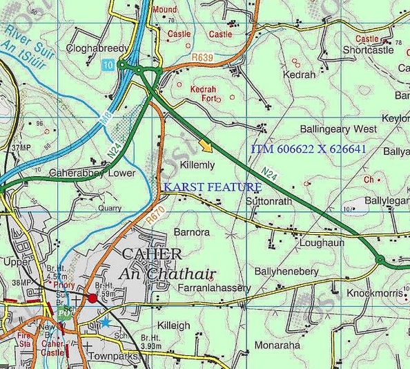
30th March Entrance curiosities, Co. Tipperary
PC
Returning from a coast guard assessment, in Tramore, Waterford, PC took this route to avoid the extensive roadworks in the middle of Tipperary Town. Located some six miles south of Cashel, on the R688, is a significant feature close to the west side of the road, (ITM 609890 x 636904). County Tipperary is known for limestone; cattle reared hereabouts considered as healthy and valuable as those raised among the Burren. Depth of the feature was estimated from the roadside as ≥5m. However, research indicates it as a quarry certainly active during the early 1800s; the area does need visiting. Another, curious, feature was noted driving between the settlements Drumminacroahy and Annacarty; estimated location ITM 593330 x 645852. Set in the side of a short section of vertical grass covered hillside is a dressed stone portal. The vertical face is no more than perhaps four metres high, above the slope softens as it rises to an upper field. In the brief period the feature was visible through the hedgerow it is estimated as some two metres high and maybe one metre wide; most notable it is in the form of a pointed, Gothic arch?, the stonework large and seemingly well lain, the joints prominent. There is no recorded site in the national archaeological database of the immediate area. Owing to the volume of farm traffic along the narrow lane a precise location was impossible to record; the given ITM was best guessed using memory, feel and the websites Myplan.ie and Archaeology.ie.
Pat Cronin
Or