Pegasus Caving Club
aka Pegasus Club Nottingham
2nd April Poulbruíon
FR, PC
18:00. Sunset 20:15: Cloud 0%: Wind E, F4: Visibility 35Nm: Rain Gauge 0mm: Temp 14°C. Ground drying: The Plan: Dig. FR resumed deepening the central east - west channel, exposing the large boulder along with others, set deep in the floor. Such meant a slow process clearing spoil from around them. The drain hole was lost, various attempts to create another were fruitless – FR having to deal with wet conditions. At the end of the session managed to drain the water to the northwest corner of the shaft and north face. The base of the north face is of concern. Am considering installing two stemples at an angle of 60° to each other, maybe 500mm apart, overlain with four short, secured scaffold poles and steel mesh. A safe gap needs calculating, just enough to install this framework and backpack it. Previous lengths of rebar driven into the boulder pile helps stability but needs a close watch if executing this proposal. Will drive in more, aiming for a length/depth of 1.2m, hopefully passing between the boulders. 20 Kibbles and 3 nets. Nice sunset and good session.
Kibbles 269, Nets 10, Hours 5, (245 total).
Pat Cronin
5th April Cullaun II
CG, PC
11:00. Sunset 20:20: Cloud 0%: Wind E, F4/6: Visibility 25Nm, haze: Rain Gauge 0mm: Temp: 20°C: Ground dry: The Plan, Tourist trip for CG. Following CG’s delight with caving offered another trip. Met in Lisdoonvarna. Tiny stream at the entrance. After describing the entrance area, set CG off, followed closely. Very pleasant trip in low water conditions - lowest noted in some time. CG’s various outdoor interests provide her with good balance. No rain these six days. CG delighted at the sculpting of the stream passage, myriad helictites etc. Reached Pool chamber after an hour or so, explaining various cave features.
Pat Cronin
6th April Pollatoomary Resurgence
Jim Warny sets new Irish & UK cave dive depth record at 120m.
See Reort Here
6th April Souterrain CL016-052003, Roughan
PC
10:30: Sunset 20:22: Cloud 0%: Wind E, F4: Visibility 20 Nm, haze: Rain Gauge 0mm: Temp: 20°C: Ground dry: The Plan: Begin souterrain survey. Notified MK of last minute decision to visit his site. Wrote a protocol to involve aspects of roof lintels, to include the ancient repair to the souterrain roof, a unique feature where a collapsed lintel was repaired using material to hand, two flagstones and large boulders, though achieving the goal of sealing the hole from below it is a poor quality repair. Perhaps attended to in haste? Had expected nettles and some briars in the entrance hollow, was not disappointed. Applied the machete removing much of the nettle growth, deployed a strip of 1200 gauge polythene, assisting entry and avoiding nettle rash to the face sliding through the low, tight entrance. Tied the surface profile surveys to the underground survey via a long, vertical clamp. A single passage, this accessible section is some five metres, width about a metre. It may once have extending a further ten metres north to what appears might have been a substantial building. Averaging 0.6m in height, the passage does not facilitate ease of switching between measuring and recording data. Abandoned a plan to record lintel shapes and sizes to obtain a normal survey on which to hang these important features. Several roof lintels are not the normally encountered, rectilinear shape - one shaped like a banana. Their setting onto walls nor their thickness is also presently inaccessible, somewhat disappointed. Visual assessments vary between 150mm to greater than 300mm. Attempted photograph the damaged section by placing the camera on the floor, a distance of around 600mm, results poor. The passage height often inhibited using the laser cross light to obtain accurate measurements, as parts of the human regularly obscured the laser beams. The western wall is nicely constructed of well-fitting stonework, some level of care or pride appears to have been involved. Ideally need a scribe sat outside in the sun recording data screamed out from below. Before descending set up a GPSR to double check the map reference, two hours stabilization gave a reading of ITM 525138 x 692412. Elevation on the GPSR was 43m, which requires confirmation. Though an adjacent Bench Mark, ITM525541 x 692388, four hundred metres away, was originally established at 146.4ft = 44.6metres.
Pat Cronin

View of lintel moved from origina setting

Souterrain entrance

Ancient roof repair

Survey set-up
7th April Poulbruíon
FR, PC
18:00: Sunset 20:23: Cloud 0%: Wind E, F1: Visibility 20 Nm, haze: Rain Gauge 0mm: Temp: 12°C: Ground dry: The Plan, Dig. FR hauling, PC digging. Dug around emerging boulders up to and removing the protruding north face, squaring it vertically with existing stemples above. Removed loosened boulders in the floor, lowered the shaft to -4.8m. Cleared along east and west walls to locate suitable points to drill 16mm stemple anchor holes, leaving a central support buttress. A nice, small stalagmite flow emerges from the west wall, it has cemented a number of cobbles. To the east the wall continues on down, mostly vertically, a minor undercut near the present floor level. This session created a distance between lowest stemple and the floor of around 1.2metres, a little too large for comfort, but needed to assess exactly what the overall status and stability of this fill is. Previously driven rebar lengths can be seen supporting boulders, between which assorted sized cobbles and pebbles rest insecurely. Like the south face, will try to drive in longer rebar lengths. Loose stuff over the central buttress was removed now to avoid delay dealing with it whilst installing the next stemple. The central buttress has a lot of larger boulders present, with a coating of thick clay. Much of this was removed to check alignment between the walls for the next stemples. Lateral pressure does not appear to be an immediate issue, but intend to install the recovered timber ‘Popeye’ donated to the Considine dig. Stout and of good quality it will serve well until a pipe is installed. Digging was swift, but cautious, FR working well drawing forty kibbles to surface and four nets, whilst assaulted by midges. Several ‘flat’ boulders were left for use in the forthcoming back packing. At -4.5m the washed gravel deposit found in the south face appears in the north directly under the clay horizon, a definite border, Descending northwards at an estimated angle of maybe 30° below the horizontal. With the large floor boulders cleared, beneath are many smaller pebbles and cobbles, all clean washed, by the small, extant inlet. Need pick up two scaffold tube lengths before Wednesday. Once these three stemples are installed with install the cross bracing. Had no tape, need nip back to measure stemple lengths and check for any movement.
Kibbles 309, Nets 14, Hours 4, (250 Hrs).
Pat Cronin
9th April Poulbruíon
PC
18:00: Sunset 20:27: Cloud 0%: Wind NE, F2/3: Visibility 25 Nm, haze: Rain Gauge 0mm: Temp: 19°C: Ground dry: The Plan: drill holes for stemples. Carried in 3 x 1.5m lengths of galvanized scaffold tubing, Hilti drill, bolts, etc. Reviewed the buttress, no collapse noted. Used the level to vertically align the anchors with those above. Issues with the second, western one, needing be installed in an area of stalagmite cemented cobbles and pebbles. Chipped away at the deposit finding it insecure and some 0.1m thick covering the wall surface. Lot of measuring to get the anchors in place, whilst maintaining the greatest width of shaft for ease of possible installation a large pipe. A step back in the west wall meant bringing both lower stemple anchors 40mm into the shaft. Vertical distance between the two anchors is 350mm, between the upper and existing stemple around 300mm. Once both stemples are secured will drive in another line of rebar. As the cavity on the west side is quite large intend drill the west wall and insert lengths of rebar into them, their other ends to rest on the stemple. Boulders protrude a little from the buttress, once the rebar is inserted intend to use any flat stones to build the packing. Stemples lengths required are 1280mm and 1140mm, the shorter can be cut from an existing length on site. Walking back, overflown by Chief Pilot Geh, heading NNE…
Kibbles 309, Nets 14, Hours 2, (252 Hrs).
Pat Cronin
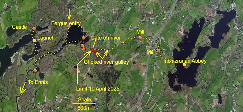
10th April Dromore Lough – Inchicronan Island
PMcG, PC
10:30: Sunset 20:29: Cloud 0%: Wind NE, F2/3: Visibility 20 Nm, haze: Rain Gauge 0mm: Temp: 20°C: Ground dry: The Plan: Kayak trip. To follow the Millbrook River east from the slip at Dromore Lough West. The name Millbrook is likely from the two Mills recorded along its course. The first, a Fulling Mill, ITM 538390 x 685980, a kilometre across the lough and a little downstream from Inchicronan Abbey. A second mill, presently unclassified, is located a further six hundred metres downstream, ITM 537930 x 686305. Very pleasant trip finding a route through extensive reed beds and small channels. Managed locate the tiny obscured channel, ITM 536475 x 686104, where the Millbrook River enters the lake, hidden among an extensive reed bed, it’s narrow, shallow, sinuous course presented no real issues until a large gate was encountered, ITM 536718 x 685994, blocking progress. Left kayaks to investigate the obvious, blasted channel beyond, wading found many blasted rocks just below water level, and at least three 1¼” shot holes. Some seventy five metres further upstream a lot of foliage has collapsed into the channel choking the next seventy odd metres, possibly from Storm Éowyn? Retraced route, stopping for a brew up in Dromore Lough East. Passed out the launch slip and into Dromore Lough West to visit the Castle, the target for Cromwell’s forces, a significant amount of substantial masonry chunks scattered along the lough edge. Frustrated at the obstructions, intend launch kayaks in Inchicronan Lough to approach the mills from upstream after a visit to the Augustinian Abbey, (CL026-014001). A Crackin’ trip.
Pat Cronin
13th April Poulbruíon
PC
12:15: Sunset 20:34: Cloud 100%, rain: Wind SE, F4/6: Visibility 15Nm: Rain Gauge 2mm: Temp: 6°C: Ground dry: First rain in thirteen days. The Plan: secure northern stemples. About to depart as Sparky and JW arrived; nice. Had prepared the upper, 1280mm stemple, in the workshop. Carried it, six one metre lengths of 10mm rebar and Popeye’s mini-grinder in to complete this section of shoring before tomorrow’s session. The previously noted steep sided collapse, (ITM 5141456 x 705207), en-route to the dig, continues to deepen, but slowly, ideally need get a large plastic pallet as a cover to avoid potential livestock issues. Believe it similar to the hole sixty metres northeast from Poulbruíon. Remain convinced the immediate area is a fault zone. Cut the shorter stemple to length, lowered all material to the bottom. Virtually no running water from the east wall inlet. Still no collapse of the buttress: delighted. Fitted both stemples, found had forgotten to pack the spanner, twat. Tightened the stemple nuts as best as could. Across the top of the lower stemple drove in five one metre lengths of rebar, each suggesting ‘looser’ area beyond the boulders, at around 0.7 metres in horizontally. Tested stability of the buttress, began to pick away at loose material, preparing the area to receive the stone packing. At one point some of the upper deposit fell away exposing a boulder of a little over half a cubic foot in size and shape, its diagonal axis resting vertical, estimated at around forty kilos, leaning against another boulder. Drove in rebar either side of its lower V shape, hoping prevent it descending – sliding further down. Somewhat concerning peering into the guts of this boulder pile. Quite a few flat stones are now stacked in the base of the shaft as back filling support behind the steel mesh, which should be completed tomorrow. Had hoped for a straightforward digging session Monday night, the need to pack the area takes precedence.
Kibbles 309, Nets 14, Hours 2, (254 Hrs)
Pat Cronin
14th April Poulbruíon
PMcG, FR, PC
18:00: Sunset 20:36: Cloud 30%: Wind S, F4: Visibility 25Nm: Rain Gauge 12mm: Temp: 7°C: Ground dry: The Plan: Continue shoring north face. Took steel mesh, Hilti drill, spanner more rebar and other bits. FR hauling, PMcG winching, PC below. Considered situation too risky for an inexperienced FR to work among. Found minor collapse of face had happened; not too much. Drilled two 10mm holes in west wall, hammered in two lengths of 10mm rebar to bridge the cavity; now half its original height. Tightened stemple anchors. Sent up several kibbles of spoil to clear the congestion. Removing loose debris from the boulder pile, significant collapse exposed the ends of two previously driven rebar lengths, each 0.75mm long. Urgently drove in the two, spare, one metre lengths to support suspended – hanging debris, removed the ‘spare’ rebar. Somewhat relieved desperation found an easy route for both rebars to be swiftly driven through compacted boulders; no change of underwear required. Slightly more comfortable, cleared beneath suspended boulders to begin building upwards layers of flat stones, spanning the rebar set upon the lower stemple, up to the boulders resting on rebar above. Delighted the rebar idea has worked so far; it avoided a massive collapse at this juncture. Hammered thin, flat stones into remaining gaps to the west side: increasingly happier. Managed to reach in to further chock the large pyramid like stone; its cap pointing outwards, ready to tip over; partly resting upon three others to the east and below. All of which rest on a large boulder slightly protruding from below the lowest stemple. Cleared spoil created by recent efforts, considering it safe enough for FR to dig the south side. At surface, in light rain, PMcG winched, PC hauled; dumping spoil to the west side of the dramway incline, which is becoming level with the trestles. FR removed the protruding south side base to present shaft floor level; -4.85m. Twenty kibbles and one net were raised. Reflecting, the very large unstable area exposing the ‘guts’ of boulder pile was caused by formation of the west cavity and the boulders having had their thick, dense mud ‘cement’ washed away buy stream action. Leaving a loose, fragmented infill; yet once both stemples were in place, a significant subsidence into the shaft would be slowed enough for a digger to scamper out its way. Working this depth inside the ‘guts’ of the boulder pile, once both stemples were secured, permitted building a substantial, supportive stonework; though at the time a little worrying. Need to take some photos. Walked back as dust descended. A rather fine session.
Kibbles 329, Nets 15, Hours 6, (260 Hrs)
Pat Cronin
16th April Poulbruíon
PC
18:00: Sunset 20:40: Cloud 50%, haze: Wind S, F4: Visibility 30Nm: Rain Gauge 0mm: Temp: 11°C: Ground dry: The Plan: Prepare for south stemple. Carried in three more scaffold tubes, there are now six x 1.5m lengths and 1 x two metre on site. Began to trim back the south face to the west and east walls searching for secure anchor sites, though each wall undulates, found two good places within 350/400mm of the stemple above. Delighted. Cleared these areas deeper in to set the stemple back further into the face vertically below the stemple above, attempting resume the working width of the shaft. Cautious poking of the gravel deposit exposed several boulders suitable to further shore the north face; more needed. Large grey clay pocket to the east side of the south face. To the west side, soft brown clay, inbetween coarse gravel continues. With no winchman piled the silt and gravel debris for the next session.
Kibbles 329, Nets 15, Hours 2, (262 Hrs)
Pat Cronin
22nd April Poulbruíon
FR, PC
18:00: Sunset 20:50: Cloud 100%: Wind S, F4: Visibility 20Nm: Rain Gauge 3mm: Temp: 8°C: Ground damp: The Plan: install south stemple. Carried up 6 x 1m lengths of rebar, one metre of scaffold tube, Hilti drill, drill bits and Popeye’s grinder. Concerned over affect of previous four days of rain on the partly exposed south face: 26mm recorded at Home. Peering down the shaft noted debris; bugger. FR hauling, PC digging. Descended, landing upon a level, clean washed, course gravel floor: debris piled to the east and south sides, with that dug Wednesday, restricting operations. Began clearing spoil, initially sent up thirty-two kibbles, (12kg/kibble). From underneath the shoring could see a lot of silt and gravel had been washed down by surface water flowing down the south side of the shaft. Existing boulders prevented insertion of a piece of galvanized iron to act as a floor to avoid such slumping: one large boulder had become loose. This slump also filled in both floor hollows dug to vertically deploy the level to align the stemples. Cleared the east hollow, carefully paring the face to drill the 16mm anchor hole into secure bedrock. Repeated process on the west side. FR supporting operations, lowering drill, grinder, scaffold tube etc. To attempt contain this unstable deposit, thought to set the lowest stemple further back, in-line with the stemple above the projecting one, to insert the two available sections of galvanized sheet, supported in turn by driving metre long rebar between the two stemples, resting on each, thereby offering support to the sheet at 0.2m centres. Creating, in effect, the appearance of a hopper, directing the pressure of contents back against the unstable deposit behind. With its base of compacted stones preventing further washouts. Intend investigate diverting surface runoff. Levelled off the ‘Hopper’ ready to top with stonework. During digging, the eastern grey clay deposit was found to be localized. To the west, the deposit remains gravelly-brown silt and clay. Some of the inlet stream runs inside a stemple falling into the western hollow, turning a compacted clay floor into porridge: useful? Sent a further six kibbles to surface and one net, a tiring, but successful session. Walked back at dusk ≈21:00. Orchids, Primroses and other blooms in abundance – alas no gentians as yet.
Kibbles 335, Nets 11, Hours 6, (268 Hrs)
Pat Cronin
29th April Bristol - St. Just, Cornwall
NB, PC
Cloudless: Wind E, F2: Visibility 25+Nm: Rain Gauge 0mm: Temp: ≈25°C: Ground dry: The Plan: View Pelton wheel remains. Departed 07:50, in traffic to the M4 for an hour. Oakhampton by 11:00. Weatherspoon’s for a late breakfast. Sciatica a mild issue: all the sitting in motors? Set up camp at Kelynack campsite (D.DM 50° 6.775N x 005°40.486W), a mile south of St. Just: £10 a tent. Descended to Wheal Call Bay to view the Pelton wheel remains, (D.DM 50° 7.690N x 005°42.212W), tide too high, much floating sea weed present. Into the Star for fine pints; disorientated return to camp via tortuous footpaths.

Pelton Wheel in northern corner, seemingly covered at High water, buried in cobbles at time of visit. Yellow path best route to south side of bay
30th April Carn Euny Fogou, (SW 4024 2885) – Bodleigh Fogou, (SW 4370 2520)
NB, PC
Cloudless: Wind E, F2: Visibility 25+Nm: Rain Gauge 0mm: Temp:≈23°C: Ground dry: The Plan: Examine fogous. References to Fogous collectively describe an Iron Age construction period and similarities with Irish, Scottish, Breton monuments. Personal misgivings required actual observation. Information sign describes three specific early, periods 500BCE – 400CE. Overall impressions suggest potential links with tin streaming/mining production. The original ‘creep’ entrance, discovered during excavation, can be considered restricting ease of access, rather than the often, swiftly, assumed idea of it a site of Refuge. Points to consider: a place of refuge, is a modern construct, storage; an observation applied where no obvious defensive features are noted as present. Some surviving souterrain entrances appear subjected to treasure seekers, such work potentially having destroyed any original entrance features. Refuge/storage - storage/refuge, possibly material/s considered valuable were stored within until needed. Reflecting, food shortages were commonplace, pilfering/stealing/rustling/raids placed a Clan’s survival in jeopardy, where better to secure portable food surplus - no matter how meagre? Processed Tin, sought by early entrepreneurs to supply the Greek expansionism demand for Bronze and trade, needed secure storage, however brief, whilst awaiting an agents return. Such a valuable - saleable commodity required protection during this period, one guard could, in theory, provide a watch, a single voice the necessary alarm.
Ignoring the 17th century dwelling, size of the Carn Euny Fogou grew to fulfils a demand over some nine hundred years, 500BCE – 400CE, as required by the community at each stage of growth a small opening provided contemporary access.
For a description of Carn Euny Fogou see:-
https://cornishancientsites.com/wp-content/uploads/2018/09/Carn-Euny.pdf
More information is availble by searching 'English Heritage'.
Pat Cronin
1st May Pelton Wheel – Boswedden Mine – Lower Boscaswell Fogou
NB, PC
Cloudless - still: Wind E, F2: Visibility 25+Nm: Rain Gauge 0mm: Temp:≈22°C: Ground dry: The Plan: various. Walk down to the Pelton wheel noted it a while until Low Water. Headed off to Boswedden Mine to enjoy the remaining features and approach the Pelton Wheel from the north side. The mine is quite superb, NB pointing out the processing plant en-route down valley from Nancherrow, plus the majestic waterwheel pit and the choked adit; worth a dig.

Northern route taken from Boswedden Mine to the Pelton Wheel, at low water
Negotiated the beach on a falling tide, the last fifty metres requiring caution. NB searched hard for the Pelton Wheel assessing its location beneath accumulated storm debris, piles of cobbles. Fair crippled with the ‘sciatica’ on reaching NB’s motor. On to Lower Boscaswell Fogou, Pendeen. Inadvertent destruction of a passage and exposure of the mural chamber occurred whilst clearing the edge of the field in the 1960s, along the Iron Age enclosure wall, by the then farmer. Rumour purports the destroyed passage was some ten metres in length. Robbing appears to have thinned the present rear of the chamber, as daylight is visible looking upwards through the stonework at an angle of around 45°. A creep enters the righthand wall of the chamber, this is, most likely, the passage referred to as being exposed and destroyed perhaps the original entrance. Surveyed the remaining feature, noting adjacent walls had large flat triangular boulders leaning up against them. The young woman encountered, a sincere person, who took the trouble to guide the team to the somewhat obscure site. Two large lintels of irregular size and shape roof the two metre square mural chamber, what appears to have made up most of its outer wall, is a single large triangular boulder lay flat, sinking into the soil where is seems to have fallen, possibly during the field clearance. Overall the fogou appears in a sorry state, though much was recorded from the surviving features. NB kindly took many photos to record the site.
Pat Cronin
11th May CL016-052003 Souterrain, Roughaun
SC, PC
11:30. Threatening cloud 95%: Wind S, F2/3: Visibility 20Nm: Rain Gauge 0mm: Temp:14°C: Ground dry: The Plan: Lintel survey. Redesigned lintel survey sheet - producing version 7. SC set up shop within earshot of the entrance, from where measurements were called to record same. Set up the red laser as a centre line: the confined passage meant running the tape measure along the west wall. The laser ensured accuracy measuring the lintels deploying a set square made from a plastic voting poster. A slow process recording significantly irregular edges on most of the lintels. Not one could be said to have been dressed into a regular, rectangular shape or form. This part of the survey worked well; a short briefing meant SC understood the record sheet’s layout able to note errors produced by the surveyor below: really useful. Thus far, this souterrain roof is the most difficult to record. Initial impressions present an almost careless approach to setting the lintels into place. However, some of the eight lintels edges are placed so their uneven edges sit above and below each other, in places actually touching - offering some amount of support across the span of the passage. Good trip.
Pat Cronin
12th May Poulbruíon
FR, PC
18:00. Cloud 95: Wind NE, F3/4: Visibility 30Nm: Rain Gauge 0mm: Temp:18°C: Ground very dry – significant cracking: The Plan: Dig. FR below, PC hauling and carrying. Lowered the floor, creating the normal east-west channel. Such leaves support to the base of both north and south faces. Couple of rounded boulders set into the gap in the north face. Remaining spoil raised to surface, placed the west side of the tram incline: thirty kibbles in total. Midges an issue, mud works, ideally need repellent.
Kibbles 365, Nets 11, Hours 4, (272 Hrs)
Pat Cronin
15th May Coolagh River Cave, B9a entrance – Poulbruíon
Elaine Oliver, Clive Owen, Julian Walford, PC
09:30. Cloud 10%: Wind E, F3: Visibility 20Nm, haze: Rain Gauge 0mm: Temp:18°C: Ground dusty: The Plan: Tourist trip. Invited to join the U.B.S.S. trip can’t remember last trip down there. Meet with Michael Hynes. In through the entrance PC piped some two years ago. Deployed ladder down the pitch, which has a permanent handline, as did the short, now desperate climb from Double Passage into Column Chamber; without it ascend is almost impossible. Floor worn away, pile of stones long gone. Very nice, steady trip to the sump, which had almost disappeared – following eighteen days of virtually no rain recorded at Carnane. No need to swim the canal: of note soft silt is building up at the beginning of the canal. Faulty memory in places; the beginning of the sump receded some ten or more metres. EO and CO crawled along the old sump area to find the extant sump a swimming pool. JW wanted exit Coolagh Main via a crawl from Column Chamber, so parted ways in Column chamber, PC soloed out. Crackin’ trip, EO particularly pleasant company, a sound human. Water level lowest every noted.
18:00. Bob Churcher, PC
Departing for Dublin Friday 16th May, wanted to catchup with BC, wandered up to the dig; fascinating conversations, ‘Looked at Dig looked OK’: met Michael Queally enroute to cattle: to the Irish Arms for pints. Nice trip, nice day.
Pat Cronin
9th June Drimcong Caves
CG, PC
14:00. Cloud 95%: Wind SW, F4: Visibility 5Nm: Rain Gauge 1mm: Temp:18°C: Ground damp: The Plan: Conduct recce of caves noted by CG. The culmination of lengthy negotiations by CG led to permission to enter the Drimcong private estate. No access into the grounds is permitted without the express permission of the owner. Prior to arrival CG’s brother proffered further data of another cave in the vicinity. Met by the maintenance man, PJ, who was informed of the visit. Though visited some years previous, CG led straight to the first cave. A dry stream channel leads from the entrance, which is at the end of a four metre high broken cliff face, in which are at least one other entrance. Entered this upper entrance, to the left of the stream channel, a minor scrabble led down into the main stream passage, though dry it experiences irregular flooding, which appears to emanate partly from a rising water table, and from water entering through surface openings near the adjacent lough. Initial passage is quite striking, beautiful water worn features and pillars: at one time a reasonable sized stream washed through this cave. Over the length of the main passage accumulated silts reduce the height to a crawl, at the end of which is a narrow joint, with seemingly little potential, through which water enters. Roof decorations are plentiful. Heading out, at least two junctions are encountered on the right hand side, the first at around twenty metres the other around forty. A pool some 1.5m deep appears to lead off as a bedding at that depth. The other, larger, junction meanders off eventually becoming too small, removal of two boulders and a bit of silt may give access to another opening to where the substantial draught is heading. Conservatively, the overall length is ninety metres. Exited the main entrance. CG took photos in the entrance area. Headed to the other cave entrance, calf muscle injury an issue, thrashing around in the undergrowth found a significant opening, seemingly a rising and perhaps sink; one hundred metres northeast of the other cave some twenty metres from the boat house. A three metre climb down reaches a pool, its level appearing to match that of the adjacent lough. Some confusion as the area was searched wherein supposed the cave entrance in which the Brother explored some thirty years ago. CG will likely enquire for further/greater/precise location details. Intend to ask to return to survey and photograph; will need a thin photographer and thin assistant. Thanks to CG for organizing the event. Stopped in Kelehan’s for refreshments. A very nice trip.
Pat Cronin

Resurgence, main entrance. Photo: Christina Galvin

View outwards, main passage. Photo: Christina Galvin

View outward to resurgence entrance
Photo: Christina Galvin