Pegasus Caving Club
aka Pegasus Club Nottingham
1st January Possible abandoned souterrain construction, Teergonean, Doolin
PC
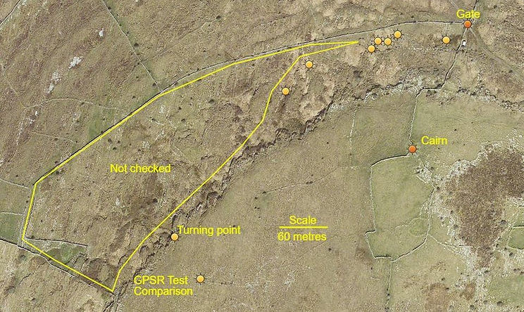
13:00. Sunset 16:31: Cloud 80%: Wind NW, F2: Visibility 25Nm: Temp 5°C: Gauge 0mm: Ground damp. The Plan: examine possible souterrain, south end at ITM 506953 x 698544. First trip of the year. Normal ground cover reduced by winter, and grazing cattle - permitting a clearer view of the curious 18 metre long, 1.25 metre wide channel in the limestone bedrock - oriented along 020°/200° mag. The channel is 20 metres from a 15-18 metre diameter cashel, circa 400-1200AD. Briars etc. have colonized some of the channel, mostly the sheltered, western side. The channel continues southwest, narrowing over the next 20 metres. This area of interest has an average width of 1.2m, similar to other souterrains in the wider Burren.
An adjacent, unregistered souterrain, recorded by Tim Robinson, (Burren Map, 1977), has been previously examined, though not recently entered, owing to dense nettles and briars. A too small opening to this was found the north side of the townland wall, within an indistinct area, possibly the remains of a hut. It is possible to get a limited view of the passage, which is some 1.4m wide, inbetween the very large lintels. During construction of the townland wall, early 1800s?, an elongated boulder, 2 metres long, (near 2 tonnes), was dressed and used to span the souterrain below, upon which the substantial wall was then built. The southern end of this unregistered souterrain passage approaches the base of the cashel rampart, and may have provided access, or emergency egress for the cashel inhabitants, via a mural passage built within the 2/3 metre thick rampart wall, until appropriately addressed and surveyed this is conjecture.
This curious channel has the appearance of a souterrain project begun, by the chieftain of the cashel, but then abandoned, after most of the clints were removed - many would have been of suitable lengths for use as lintels to roof the passage. But, why, if indeed it were, would it be abandoned? If actually a work in progress, and if abandoned, the reason is all but impossible to acquire, or guess; was it hostilities, pestilence, forced migration, family confrontation or division, lack of funds, death of the original commissioner, who would likely have been the Chieftain of the adjacent Cashel. Perhaps this Chieftains overlord, denied him permission for its construction, after the fact? A considerable section of this channel is of average souterrain passage width, commensurate with previous recorded passage widths and lintel lengths. The vertical walls, are weathered, therefore chisel marks or similar evidence may be long eroded with the annual rainfall these past thousand years, or so. More work required.
Pat Cronin

Satelite view of site

Principle area of interest

View south, wider area of channel
2nd January Poulbruíon
PC
13:30: Cloud 40%: Wind NW, F2: Visibility 30Nm: Rain Gauge 0mm: Temp: 5°C: Ground damp: The Plan: strip dramway. PMcG still in Dublin, FR unavailable. Still no trailer. Enroute bumped into MQ, spent a very pleasant 30 minutes catching up, informing him of mothballing the dig due to solo efforts, he eagerly offered to help, adding, not a bother restarting it, or digging any another site anytime. Parked up, bumped into LS, walking Gleninagh to Roadford, kindly offering assistance to carry the material down; explained needed the trailer. Had another search around, picked up another couple of bits from among the long grass. Began disassembling the dramway, corroded bolts a frustration - applied ‘Popeye’s’ mini-grinder. Worst task – removing the rails from binding grass, a real ball ache. Removed both trestles. Three lengths of ‘rail’, or Considines ladders’ to come down, a fertilizer bag of metal bits, four kibbles, one role barb wire, P.V.C. panel strips, a cushion, a couple of short bits of rail. One ladder already brought down to the second terrace, the bag of rope also recovered. Hope for a trailer for tomorrow, to take advantage of LS offer of help around 11/12:00.
Pat Cronin
3rd January Poulbruíon
CC, LS, PC
09:30: Cloud 60%: Wind NW, F2: Visibility 35Nm: Rain Gauge 0mm: Temp: 2°C: Ground frozen: The Plan, convey kit to Trailer. Managed locate and recover a trailer. Sent message of success to WhatsApp digging group. Headed to the dig. Began to work away, dragging the heavier bits down to the Drover’s Road; CC and LC arrived, remaining materials swiftly conducted to, and loaded on the trailer. Can’t believe had previously carried these ladders up to the dig, the recent TURPS operation, appearing to have a more significant effect upon the body than appreciated. LS followed PC back to Carnaun, to unload the assorted kit. Bumped into Ita, (Walsh), and Suzanne Linnane + three others, KW now living in Doolin.
Prior to departing, looked hard at the site: Poulfantaiseach, Pollapooka, Halliday’s Hole, and the resurgence volume issuing off Arkeen – together suggest a system does exist beneath. Intend return and, like Considine’s, remove the entire debris fill behind the northern shoring, in doing so, like Considine’s, gradually remove the northern shoring. Discontinue sinking a shaft, that requires shoring two unstable sides. As depth develops, below present -5m, if required, prepare a series of shored steps down the developing slope.
Retain and brace the southern shoring, presently retaining a damp silt/sand/gravel deposit, containing assorted sized boulders, down, and through which, flows much of the surface runoff originating from the wider depression and upper slopes, after heavy rain. Achieving -5 metres, grade the floor, if practicable, to a stable angle, say 4o°, down to the north, between the two solid tapering rift walls. These solid walls likely required little or no shoring. Issues of removal will increase a metre below the present platform level.
Below, and partly above, the stream entry point, loosely compacted northern boulders have little silt or mud inbetween, at this depth, (-5m), drain points for ponding water were easy to create, draining swiftly. In short, the lower area of the northern end is a tapering rift, full of loose boulders, with little or, no mud/silt present. Estimate the volume of material to removal to achieve -5m to be, worst case, between 4 and 6 cubic metres.
Pat Cronin
6th January Unnamed Tube
PMcG, PC
14:00. Cloud 95%: Wind NW, F3/4: Visibility 5Nm: Rain Gauge 16mm: Temp: 6°C + wind chill: Ground wet: The Plan; walk. Nollaig na mBan. Met up with PMcG, on his recent return from Dublin. Took a walk along, and down the coast, visiting the souterrains of Ballycahan and Teergonean enroute. Relocated ‘Unnamed Tube’ a site previously dug by CMcG and PMcG latterly joined by CC and PC. An initially three metre wide, NW facing entrance, contains many boulders, (60-100kg). Beyond these a gap remains allowing access to the tube, (dig face): a coarse fill of cobbles, and sandy silts. Digging would contend with such boulder deposits from winter storms, which continue to contribute to the half kilometre long storm beach, that extends inland almost twenty metres above this site . A very pleasant wander.
Pat Cronin
10th January Poulacapple Townland, eastern area
PMcG, PC
11:00. Cloud 100%: Wind WNW, F4: Visibility 15Nm: Rain Gauge 2mm: Temp: 6°C + wind chill: Ground wet: The Plan: Prospect the Townland to the NE. Picked up PMcG, parked near Poulacapple Pot. The harvesting of pine forestry continues apace approaching Cullaun V, following removal of some forestry on the north corner of the Poulacapple track junction with the N67,(ITM 519447 x 701839). Some forestry south of Gragen West Cave has also been partly removed. Followed the track north, drifting east just beyond the gate, ITM 518600 x 704120, encountering significant depressions, two being intermittent sinks. Continued along the track to ITM 518725 x 704510, where the track turns northwest; taking a route along the edge of the moorland, heading SE, a large prehistoric cairn, (Neolithic?), is a useful reference visible from afar, close by it is an unregistered cist, (also Neolithic?), included within, what appears to be a lengthy, Bronze Age wall, (2200BC- 500BC). After a hundred metres turned downhill where the wall also descends. Descending the shallow slope, located two depression/ holes. Pressed on downhill through two areas of long neglected Hazel thickets, to where the programmed GPSR sounded arriving at the target point, an area beneath a wonderful, woodland canopy, draped in mosses and lichens - found the eastern side of the broad channel/gulley, used this to orientate: around this elevation much evidence of man altering aged stone walls, believe noted a track near the target point, most likely 19th century, to access this area of coppicing. Had tea and medals, began to ascend the wooded slope keeping slightly further north, heading SW, more sounds of gunfire, through from an increasingly remote distance. Approaching the plateau edge encountered several nice sites, expanded the search finding more - the deepest, a pot entrance of four metres, one of three holes aligned NE/SW. The area used for grazing. Called into the Irish Arms for hot soup, and medals. A very nice afternoon.
Pat Cronin

New Sites adjacent to Poulacapple Pot

View west towards Poulacapple Pot

View towards Ballyvaghan near pot

Collapsing sink

Four to Five metre deep pot
19th January Poulacapple vicinity
PMcG, PC
13:00. Cloud 10%: Wind W, F2: Visibility 25Nm: Rain Gauge 8mm: Temp: 6°C: Ground wet: The Plan: Prospect northwest of that visited 10th January 2026. Parked at the usual location, noted new bales of silage near the Gate and distributed adjacent the northern reference point, ITM 518720 x 704510. Headed to the predicted area, NE of the stock enclosure, near the wall. Found three conical depressions, the northernmost, Pot1, being the deepest, (7m). Set down the kit, to wander the area – possible this area is commonage, then again, possibly not. Need speak to Paul Mac’, or Martin O’Loughlin to ID the owner. Similar to SE of the wall, found depressions, shallow and deep. Most surprizingly was finding a resurgence and active sink, with adjacent overflow sink, and pronounced channel. Two most significant sites are Pot1 and RP01. Pot1, being a 7m deep, conical depression, with limestone wall, and boulders in its base. Far, far more attractive is the pot like entrance at the base of a small terrace, loose boulders in its base. Permission to dig will be urgently sought, once ownership is established will commence digging. Erecting a fence of paramount import, evidence of farmstock everywhere. Would be useful to have permission to bring the motor to the track junction, with materials. Delighted.
Pat Cronin

Paul McGrath at RP01

Paul McGrath in Pot 1
21st January Poulacapple Townland
PMcN, PC
Called to Paul Mac: en-route remembering, from 2006, the reply, the late, Micky Vaughan gave to the question - who owned land of Poulacapple Pot, and that beyond the wall?
The area surrounding the cluster of conical depressions, including Poulacapple Pot, though divided up by the Land Commission was only, partly, ever dug for Turf, the immediate pothole treated with dire caution.
MV further explained, very little turf cutting had taken place here these past fifty years, (2006), as many of the owners had left for America.
In PMcN’s kitchen spread out the maps, he commented the area was likely owned by a close friend.
PMcN tried ringing his mobile; no reply.
If he does indeed own the land, the chances of permission being granted are good - having previously met him, on very good terms, last year at PMcN’s. Am optimistic.
22nd January Poulacapple Townland
PMcN, PC
Spoke with Farmer - warmly welcomed PC's interest - permission enthusiastically granted - exchanged phone numbers. Thrilled.
23rd January Poulacapple Pot
PMcG, PC
10:30. Cloud 100%, in Cloud: Wind E, F6: Visibility, initially 5Nm: Rain Gauge 1mm: Temp: 6°C: Ground sodden: The Plan: Descend shaft. Last trip by CC and PC, 4th November 2006. Pipework was disconnected, with the theory for the cascade to pound the silt base of the shaft, 23rd December 2015. Changing, on the summit, unexpectedly met the Farmer – lengthy chat, clarified intent, he responded, describing numerous other sites. Parting, all delighted, and frozen. Can’t beat the personal touch.
At the shaft no spillage of water over the old dam, both streams contained in the pipe. PMcG, first dressed – after fitting the final clip securing the galvanized scaffold tube frame, rigged the pitch with SRT, and a 10m ladder, then slid down, joined swiftly by PC. Previously imagined sight of an exposed 4 inch pipe, was wrong, it's a piece of 4 x 1 inch timber. The base of the shaft is running with water, from runoff off the track, enhanced by addition channels. The potential 4 inch syphon duct is secure within the previously constructed, substantial, concrete block support, behind which extends previously dumped spoil. Much of the ‘old’ floor is gone, about a metre of depth washed away by the cascade, exposing a rib of rock, trending south, a 0.7m deep channel, on the left, is cleared out for some four metres, narrowing at that point to an estimated 0.2m, though continuing. This channel has been washed out to bedrock, to its right a lump of bedrock is the floor of a joint, of assorted material – gravels, pebbles – silts etc. and one protruding bone, outside diameter, about 50mm, some0.3m above is the bottom edge of the large boulder. This boulder is in fact a large flake, its rough edge offers secure points to install three stemples. The gap between flake and bedrock is diggable, the spoil could be back packed into the area beneath the concrete block syphon duct support, when full, into the rift. Both now very wet, from the heavy 'rain'. Overall, a metre depth of the floor has been washed away, down to bedrock.
Inspected the concrete block and galvanized steel shoring containing the shale/clay fill in the ‘south end of the shaft, directly below the working platform, it remains solid and secure but should not be climbed upon. At the ‘pinch’ point, 0.4m wide, snug dimensions temp the struggling SRT climber to use using the east wall. Whilst the protruding bits appear firm, these too should not be as foot holds. Several kibbles and remaining materials will likely be removed to the next dig northeast of Poulacapple.
Pat Cronin

Poulacapple Project Area
26th January Poulacapple Project
PMcG, PC
10:30. Cloud 100%, in Cloud: Wind SE, F4: Visibility, 2Nm: Rain Gauge 2mm: Temp: 6°C: Ground sodden: The Plan: assess site by resurgence. Picked up PMcG at Gragens Wood. Noted the field gate open; parked in usual place. Apparent direct route to the cairn area avoided, kept to the track to the primary reference point, (ITM 518720 x 704510), from here cut southeast, to the water meadow below the resurgence, en-route PMcG found another site; a small, vertical opening to a narrow rift, (No GPSR to hand). Before starting PMcG took photo of site. Grasses removed - exposing very large boulders – between which, could be seen a cavity. The boulder fill does not seem placed by humans, however, builders of the nearby archaeological site, within the area of the water meadow, may have had sometime to do with it? Deployed the sledge to great effect, reducing the boulders to manageable sizes. Debris – clay and small stones fragments placed along the bottom of the gryke above the dig, to avoid a spoil pile, larger boulders kept to one side as potentially support for the clay face, at the NW end of the opening. The cavity has a level-ish floor surface, continuing into a low bedding heading NE, its floor, washed debris. Intend drop the floor a metre to see if any development below - buried. The largest conical depression will next be probed -70m distant on 170°(T), halfway between these two features is the nearest feature – another steep sided conical depression some five metres deep. No tools left on site. Promised rain attempted to arrive. Changing the Farmer appeared from the cloud; chatted, gave him an update, mentioned the open gate, unconcerned, all cattle moved away northwest: he’ll notify PC when calving begins. Irish Arms closed.
Pat Cronin
31st January Poulacapple Project
PMcG, PC
11:00. Cloud 20%: Wind SW, F2/3: Visibility, 10Nm: Rain Gauge 2mm: Temp: 8°C: Ground sodden: The Plan: Continue prospecting. From fog, in Doolin, broke out into bright sunshine ascending the track to Poulacapple summit. Parked in the usual place, walked in. From the main reference point ITM 518720 x 704510, headed almost due east, (True), to the top of a significant gulley. Near its head found a small spring; negotiating the densely, foliated gulley a real pain - Hawthorn, Briars etc. wove an erratic route through the scrub, rewarded with, in places, a 7 metre deep, 20 metre wide gulley, with boggy areas, clearings and fifty metre long limestone bluff, really nice. At the Northern limit, for today, took an ITM to reference – few enough features down here to clearly reference for future visits. Climbed up the eastern edge encountering previously recorded sites, yet finding more unrecorded. Departed Sector 1 - at a nearby junction of three walls, used the feature to assess todays GPSR field error - being 4m north, compared with digital mapping. From this junction ascended the slope, trending SW, recording more sites: today’s total 19, delighted.
Reviewed the deep depression, plan to erect a barrier to initially secure a limited amount of loose spoil, whilst establishing best practice to enlarge the visible, vertical hole in the bottom of this, near vertical sided depression. Have an obvious SW limestone face, but unsure of NW and NE sides, each presently hidden by grass etc. the SW approach slope will take the traffic and spoil. This depression is at the bottom of three descending to the NE, at an elevation of 274OD. PMcG took lots of arty photos. Tea and medals enjoyed beneath encroaching cloud.
Pat Cronin

In the gulley

Resurgence to dig at far limestone

Deep depression
2nd February Poulacapple Project, L117, depression and, L119
PMcG, PC
10.30: Cloud 100%: Wind SE, F6: Visibility, 20Nm: Rain Gauge 1mm: Temp: 7°C: Ground sodden: The Plan: Assess L117, a depression, and Poul beag asail, (L119). Changed swiftly in a chill wind. Encountering the owner, enjoyed another convivial exchange. From motor to L117, about a fifteen minute walk. Poked and prodded the base of this deep depression, accessed down a ≈45° water logged slope. Issues occurred with slope integrity, that began to deteriorate after a dozen or so ascents and descents - dumping spoil. The visible parts of the SW? wall are heartening. The site appears developed along a N – S axis, give or take - compass bearing required. As PMcG continued to remove the base, boulders were encountered beneath iron stained silts, and grey clays. Further use of the slope caused more deterioration. Planning a support frame need take account of the other sides – probing did not meet with welcome resistance, securing an all-important frame will be problematic, but urgent. Further exposure of the base requires preparing a reasonable area in which to work. Initially, with “coffin dam” sides to deal with the very unstable peat/grassy sides.
Recovered kit, had a brief look at L116, the middle depression, almost as deep as L118, but with a wider, firmer base: an undercut may be worth developing. To complete the session moved on to L119, Poul beag Asail, some 55 metres away, a little west of North. En-route passed L118, another deep depression. PMcG arrived first, with spade quickly clearing the ‘shrapnel’, surprized at the angular nature of much of the smaller debris, other than the bedrock, no evidence of water rolling among the spoil. Changed places, with the floor clear began to follow the it into the bedding; debris cleared reasonably easy. Toward end of play, the Team not too enthused with the solid surroundings. However, prior to exiting PMcG noted the southern end of the ‘rift’, the width of bedding seemed increasing, and to also descend. Spoil deposited along the margin of grass and limestone terrace; a year should see vegetation colonize this silty spoil. Boulders remain stacked adjacent the entrance. Prior to departure PC outlined a new approach to digging Poulbruíon, whilst enjoying tea and medals, out of a biting wind: a chill walk back. PMcG took photos.
Pat Cronin

Poul Beag Asail L119

Poul Beag Asail L119
9th February Shallee Mine, Silvermines, Co. Tipperary
PMcG, PC
10.30: Cloud 80%: Wind E, F2: Visibility, 25Nm: Rain Gauge 2mm: Temp: 9°C: Ground dry: The Plan: Tourist trip. Grammar correction, Poul asal beag; thanks to PMcG. On arrival, disorientated. The track, when found, festooned by keep out, and danger notices. Rang the displayed phone number… Spoke with one of the guardians, explained interest in industrial archaeology – initial, stilted conversation changed to one of welcome and great interest – from vague, possible future appointment, to call me anytime - lets meet up. Deferred act of trespass to wandering around the quaint, desolate village of Silvermines. Up the road to the left of the school, on the left, from a marked footpath, rises an impressive, thoughtfully conserved Cornish engine house, beyond which a partially conserved Smelt Mill exhibits numerous periods of change, really nice. The footpath continues, meandering scrub and extensive spoil landscape, passing a ten metre cliff/cutting, at the base of which are six entrances = four shafts – two ‘adits’, both with water. Some entrances recently fenced off, passing locals related that in this area the emergency exit was long filled in - due to flooding, an adjacent shaft never reached its intended depth. Recorded a few of the many sites, later openings not on the maps. A Grand Day Out.
Shaft – ITM 583651 x 670840 Elv 157m OD.
Shaft – ITM 583675 x 670853 Elv 155m OD.
Shaft – ITM 584107 x 671046 Elv 142m OD.
Engine House - ITM 584036 x 671102 Elv 131m OD.
Smelt Mill - ITM 584148 x 671044 Elv 141m OD.
Building complex ITM 582885 x 670962 Elv 149m OD.
Centre of Three openings 1 x Shaft and 2 x ‘adit’s’ ITM 583719 x 670847

Information Board

Remains of the Waelz Furnace

Restored Engine House
14th February Poulacapple Project
Stephanie Clark, Paul McGrath
11:00 Cloud 100%: Wind SE, F5 – F7: Visibility, 0.5 - 20Nm: Rain Gauge 0mm: Temp: 1°C: Ground frozen: The Plan: Prospecting Poulacapple. SC arrived at Carnane, collected PMcG from Gragens Wood. Motor parked in usual place - rain promised around 14:00. In chill wind moved west from the Gate: ground uneven, elevated clints – expanses of heather and grass, leg wrecking country. Began to follow the margin, no shale seen, overburden seeming just Bog. Meandering west SC noted an archaeological feature – another 70 metres beyond, possible tombs? Surveys required. Continued wandering northwards, finding four sites - holes and depressions, to the sou-sou-east, among a corridor of exposed karst, are areas where surface water ponds, these ‘soakaways’ evidenced by their flat silt areas. SC found ringfort, cashel, (CL005-015002). West of this guessed the sturdy field wall to be a townland division, ground beyond of alternate ownership? need check. Wandered north to an obvious prehistoric Cairn, (CL005-015---) – other summit cairns visible eastwards. Crossed into Faunarooska townland, not to be mistaken for the Faunarooska townland, Sliabh Eilbhe - above Fanore - 4 kilometers further west. Found a bedding opening with gravel floor. Stopped for Tea and Medals in this sheltered hollow, the odd, snowflake arrived, wind increased to F5-7, snowfall too, lost sight of Sliabh Eilbhe. Headed SW along the Limestone – Bog margin to ITM 518240 x 704980, snow arriving horizontally. Prior to starting back PMcG ascended the high ground to the south checking terrain for a shorter route, vis poor, chose to head mostly northeasterly to skirt deep, wet areas of the Bog. To the Irish Arms for Tea, soup and a warm up, and last forty minutes of Ireland-Italy, Ireland won 20 -10. Crackin’ day.
22nd February Poulacapple Project
PC
11.30: Cloud 95%: Wind SW, F7: Visibility, 10Nm: Rain Gauge 19mm: Temp: 9°C: Ground wet. Rain promised. The Plan: continue prospecting. Chose to check the area near the base of the north facing, limestone terrace, an area adjacent, and below that recently visited with PMcG and SC. Here the surface is also treacherous - ankle wrecking country. Slow wandering among numerous features, found seven depressions, more may be either side of the narrow route taken. Progress slow, impeded by significant gaps, up to three metres wide and five metres deep ending at the base of the terrace. Noted an area to the north and below the terrace edge, a wide flat-ish area, where multiple concrete troughs have been neatly constructed, several large, modern plastic tanks appear to await installation. Depressions noted today are not as developed as those on the northeastern slopes of this mountain, there seems, in many places, a deeper depth of soil cover. Rain arrived as returned to motor. More work required. Russel weekend, a good number visiting the village.
Area of located sites
26th February Shallee Mine, Silvermines, Co. Tipperary
Sean O’Conner, PMcG, PC
14:00: Cloud 95%: Wind SW, F2: Visibility, 20Nm: Rain Gauge 7mm: Temp: 13°C: Ground ‘mine spoil’. The Plan: Meet mine owner. Made a swift run after a CT scan appointment, arrived with two minutes to spare. A conversation with SC, on the 9th February, invited PC to meet up on site. Met at - ITM 580482 x 671539 - decimal degrees 52.794512N x 008.289415W - the base of the access track. After introductions took off in SC’s motor around the complex, a pleasant man delighted to show the wonders he’s purchased. First stop the western workings, accessible across a large pool, adjacent this pool other accessible workings steeply descend through plenty of passageways and shafts. In the main deep opencast - eastern workings, on the ledge, overlooking the lake in the cathedral stope is a very nice stratigraphic exposure of differing thicknesses of shale/sandstone depositions, from ≈1mm to ≈150mm. Long chats, much information exchanged, frustration of dealing with protracted vandalism, now under control – all access banned. Offered access, almost anytime, SC offering to leave key on site, should he not be available during organizing this project. Asked for a trip arranging for around two weeks’ time. Cracking Day.
28th February Caher Mor, Northern Sliabh Eilbhe
PMcG, PC
10:15: Cloud 80%: Wind SW, F4/5: Visibility, 25 Nm: Rain Gauge 0mm: Temp: 9°C: Ground dry. The Plan: attempt relocate a choked shaft. Picked up by PMcG, dropped maps into MM. Parked, ITM 515050 x 709102 – Decimal degrees 53.125688N x 009.269262W. Ascended west side of the bluff: Caher Valley Cave located on the east side some twenty five metres above the road, ITM 515141 x 709029. The west side of the bluff of superbly defined limestone. At the substantial field wall, overlooking Fanore, headed south-ish - the choked shaft, a circular pot, filled with level stones, was in a large piece of flat karst. Have twice failed to find it - alone, and with ML. Tied this trip in with improving fitness. Found the spring, but flow too small to suit MM’s needs, continued along this terrace to ITM 514684 x 708093. Ascending, split up, PMcG taking the next terrace above, turning north, no luck along these either, repeated search pattern, without any luck. At the northern brow, ITM 515280 x 708596, turned south ascending in a zig-zag pattern to a wide, almost featureless expanse of terrace, at 240m OD, found a handy reference for the search limit – a sub-circular, possible prehistoric enclosure at ITM 515122 x 708128. Am beginning to doubt memory, though the choked shaft was also witnessed by Brian McMahon, during participation in a IRCG training course. Began return, caught out by a vertical section of cliff forcing descent to the north. Into O’Donoghue’s for refreshments, the new management, consisting of Paul Shannon, manager, and Donal Hynes, owner of sink G8, dug with ML in the late 1990s. Arranged to meet with DH regarding a curious hole in Noughaval.
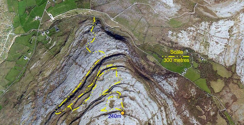
Aerial view of area searched
2nd March L118, Poulacapple Project
10:00: Cloud 50 - 100%: Wind SW, F4/6: Visibility, 30Nm: Rain Gauge 14mm, showers: Temp: 12°C: Ground sodden. The Plan: Dig. Arrived at L119, (Poul beag asail - need check grammar). Studied the area needing removal, suggested quick look at L118, 25m away, almost aligned between L117 and L119. Noted an area between L119 and L118, suggesting a confluence of subterranean flow. Pulled up a tuft of grass, exposed a 1.2m deep hole, between solid limestone, the eastern wall ended at a depth of about 0.7m, displaying widening beneath. Dug down through soils and clays. Gradually exposing the tri-angular hole. Enlarged the south end hoping to slide into the slowly widening gap. Doing so exposed a large, almost vertical, lintel shaped boulder, (≈70kg), needing removal to squeeze into the cavity. As PMcG wroggled the boulder the ‘solid’ western face dropped away beneath him - the clay it was stuck to, finally gave up adhesion; close. Lots of looking at each other, many theories of how best to remove this lump from its awkward landing place, in this remote location. The final plan is to dig away the western clay deposit, and hope to drop the 2m x 0.5m x 0.225m, (≈250kgs), boulder into the gap created, and on it stack stone removed from what appears to be a partly choked shaft. Tea and medals in the lea of the resurgence gulley. Chill walk back.

Explanatory image of the resurgence area, codes and flow
8th March L118, Poulacapple Project
PC
10:30: Cloud 100%: Wind SE, F4: Visibility, 15Nm: Rain Gauge 0mm: Temp: 10°C: Ground wet. The Plan: Dig. Carried in another kibble. Concentrated on preparing the west side of the entrance for dealing with the boulder that fell off. Need a spade, with a sharp edge - digging through the reeds and grasses demands effort. Deployed both kibbles to reduce amount of climbing in and out the depression for hauling. Created an inclined area for hauling and allow enough room for the sledge to be swung to break up the boulder – Hilti drill and Gads required. Left a narrow baulk between the base of the hauling slope and entrance opening, to prevent spoil migration. Spread spoil thinly across the surface to avoid a spoil heap.
Pat Cronin
Boulder fallen from western clay face
14th March L118, Poulacapple Project
PC
14:45: Cloud 60%: Wind SW, F4: Visibility, 10Nm: Rain Gauge 6mm - heavy showers Temp: 8°C: Ground sodden. The Plan: complete the hauling route. Dug out the baulk, lowering the area to extend the hauling slope to the edge of the entrance. Followed the edge east, to the exposed limestone ‘face’. This face ends, like a ships prow’ projecting over the possible shaft beneath. Could not see any solid rock on the west side, only clays – brown and grey. Accessing the depression, kept to the southside. Eleven kibbles of spoil removed. Looking into the cavity, the clay forming the west wall may need temporary support whilst clearing the cavity, bracing can be secured off the limestone east wall.
Pat Cronin
22nd March L118, L120, Poulacapple Project
PMcG, PC
10:30: Cloud 100%: Wind NW, F4: Visibility, 15Nm: Rain Gauge 0mm. Temp: 12°C: Ground wet. The Plan: Dig. Picked up PMcG at Gragen’s Wood. Sun attempting to break through low cloud. Began to clear down the back of the slab, rocks encountered in the clays, cut out a sizable area of the deposit, some half way down encountered soft multi – hued grey clays, among the stiffer drier layers, one of moist consistency. Believe this suggests the general direct of previous stream route. Removing the clay fortunately encountered a second slab, in near vertical axis, offering natural shoring, overlooking the hole in the floor. Yet, prevents the plan of digging out just enough clay to push the large slab over into the horizontal plane, upon which to stack dry stone spoil. Variety of stones found among the clay. Some head scratching - intend remove more clay wall to accommodate the lump intended for breaking off, lain as a useful flat surface. To achieve this will need to split the two metre long x 100mm thick slab: within this narrow width, drill three inline 10mm holes, to 400mm depth, drilling the central to 20mm diameter, using this hole to drive the gad downward, using the short handled sledge. Capping should reduce this thickness of slab swiftly. Prior to departure managed to move the slab back and forth, showing PMcG had successfully cleared down to the slabs depth. Had previously taken a bearing along the exposed joint face on 009°/189° Mag. En-route to motor poked at site L120, the active sink below rising L122: one wall of bedrock, and small, loose, washed boulders - a fine site, a Crackin’ day.
Pat Cronin
27th March L118, Poulacapple Project
PMcG, PC
10:30: Cloud 75%: Wind WNW, F4/6: Visibility, 12Nm: Rain Gauge 11mm, Showers, Hail: Temp: 9°C: Ground sodden. The Plan: Dig. Arrived with Hilti drill, 2 x batteries, drill bits, sledge, Gads, Tea and medals. PC drilled a 10mm pilot hole, reaming it out to 20mm for the Gad, the 20mm drill bit becoming aged: needs replacing. Inserted Gad, deployed sledge, though narrow, it took a good number of smacks with the sledge to crack the elongated boulder. At first a large lump broke off, the remaining pieces swiftly followed, PMcG took over reducing the remaining large section to, mostly, minor debris. Larger lumps utilized as steps among areas in the depression becoming quagmire like; the rest heaved out the depression to form a small, neat, dry stone wall. Much more clays were removed, enlarging the collar of the potential shaft – though subsequently exposing the vertical flagstone – once considered as shoring to the clay face. Slowly widening cracks announced its impending collapse. Cleared its apex from the present, stable clay roof, manhandled into an inclined position for best presentation for the sledge - this 1.5m x 0.35m x 0.2m lintel like flag was also swiftly reduced by PMcG. Both boulders exhibiting a sparkly, crystalline structure, their straightforward destruction by a short handled sledge suggestive of latent stresses. With the clays, and debris removed there is now a good working area - the adjacent clay wall need be squared off, and removed. Prior to departure suspicion made PC poke at what appeared to be west side bedrock, alas, no such luck, it is a third flag, its corner edge, and narrow width the clues. This may be stabilized as wall support. Confident the stippled wall, opposite the entrance, is bedrock. All spoil removed to date, estimated as 1.5 cubic metres, around two tonnes. Need the short ladder from Poulacapple Pot – the entrance is deepening. A cracking day.
Pat Cronin