Pegasus Caving Club
aka Pegasus Club Nottingham
4th July Considine’s Cave, (South End)
PC
Cloud base <100m: Visibility <1Nm: Wind SW, F4 gusting F6: Small stream: Ground firm: The plan; install and secure the western, horizontal scaffold tube. Had made some rebar staples to secure scaffold tube to the rock. Reused the previous SRT rope route and set up; though appropriate for working on the south end, the rope route through the working platform caused issues excavating the northern hole, which is on good limestone. Unfortunately no limestone is present at the proposed point at the southern end, only compacted clays. The integrity of this deposit is non-existent; to address this issue the length of scaffold tube need be increased to some four metres, this will reach from the northern end to the exposed limestone on the far side of the hauling shaft frame, and will require two vertical stanchions either side of the original channel of the stream. Only when this horizontal tube is secured in position can the lateral tubes be accurately measured to span the shaft, estimated at around 2.2/2.3m long. Dangling in the shaft, eyeing up the two, both western and eastern fixing positions appear reasonably level with each other, hooray. Asked Jonathon for scaffold clips, believes he has a bucket of them somewhere, if found PCN can have them. Even so, have previously arranged for Tony Boycott to order some from Tubes, Clamps Direct Ltd. To reduce courier costs TB will arrange delivery to his place then here on his return sometime soon, August? Twenty clips of two types for £44; excellent.
Hours 2 (2556), Southend (1506), Kibbles 0 (4985), Nets 0 (832), Total 5817.
10th July The funeral of Pete Watkinson


11th July Considine’s Cave, (South End)
CC and PC
Sunny: Mild: Cloud 30%: Visibility 35Nm: Wind W, F2: Small stream: Ground firm: The plan: install two pins to secure vertical scaffold supports. CC untwisted the lifeline; a lengthy, but pressing task. PC clambered into the shaft around its western edge to drill the two 16mm holes; the re-jigged SRT rope route not too successful. Distances between the horizontal bar differ, each hole is in a different bedding, yet both in the best position directly beneath. Each hole is 100mm deep; the northern hole has had its galvanized pin inserted; the pole will slide down over said pin to rest upon the rock, stopping any potential, lateral movement. Asking around no other source of scaffold clips has been located, so far. PC’s, (used) Hilti works well, with its Lithium battery it’s some 1/3rd lighter than its predecessor; use at arms length is easier. With JW’s four metre scaffold pole, the purchase of a further two six metre poles should complete the grill; once TB returns with the clips from the UK. This grill will provide peace of mind for the Team as the wooden pallets, which make up the working platform surface continue to deteriorate. Also, on completion of the project, the landowner will be left with a secure cover over the open pot by grateful Cavers; hopefully ensuring future access. No bars open as yet for a cool libation, bugger.
Hours 2 (2558), Southend (1508), Kibbles 0 (4985), Nets 0 (832), Total 5817.
Pat Cronin
15th July Considine’s Cave, (South End)
CC, PC
Cloud base ≈100m: Visibility <300m: Wind W, F2: Small stream: Ground softening: The Plan: begin installation of redesigned comm’s system. CC had busied himself redesigning the comm’s, and replacing the former 20w epileptic, disco lighting with PC’s similar lamp of 10w. All equipment swiftly conducted to the dig via a wheelbarrow in one trip; the battery a particularly hefty item. After discussing options PC descended to release the two comms cables running down the ladder way to the bottom; during ascent threading said cables back through the working platform structure for re-routing, intend to run both cables directly down the southern half of the shaft. The “Plank”, (-14m), was found covered in debris from holes prepared to receive the forthcoming surface scaffold grill; this was cleared, “Plank” and the staging washed clean removing risk of missiles on anyone below. Though hampered CC swiftly assembled and tested the comm’s system: superb, no more screaming in the shaft. The floor of the Shaft, (≈-21.5m), is reasonably level. A rib of mixed debris, separating each half could be removed in one session. Once the comms are reinstalled in the shaft, for digging to progress, present circumstances require a third man otherwise the project will not continue, efficiently. Generator ¼ full: no fuel on site. Opening of bars delayed until August.
Hours 5 (2563), Southend (1513), Kibbles 0 (4985), Nets 0 (832), Total 5817.
Pat Cronin
16th July Cullaun II
PC
Cloud base 200m: Mild: Wind W, F3: Itching for a trip also needed to exercise the lower back structure. Scampered off to pool chamber; good flow at the cascades, though stream never more than ankle deep, and of poor clarity. Observed walls were entirely wet, no area/s of dryness noted throughout, similar noted in the dig; is this due to extant period of elevated humid… low cloud base?
Pat Cronin
18th July Considine’s Cave, (South End)
CC, PC
Cloud cover 10%: Warm: Wind W, F2: Visibility >20Nm. Small stream: Ground softening: The Plan: complete installation of comm’s/signalling system. Both cables were completely recovered then threaded along their respective routes, removing the need for both coils of spare length stored adjacent the winch. PC descended to locate the signals box at -20m, from whence it was raised and lowered to prevent damage from inundation, previously witnessed, and further evidenced with the deployment of tale-tells showed it backed up to around -15m. Future flood issue may however be avoided with the exposure of the southeast rift. Experienced issues threaded the comm’s cable through and a round the shaft cover; it now runs obliquely from the shaft collar down the west wall to the south rift. No chance whatsoever of it catching in/on the hauling line. The phone line, (comm’s), is secured in the south rift; the phone will be recovered each session, being at risk. Generator remains ¼ full. No fuel on site. Site now ready for actual digging.
Hours 3 (2566), Southend (1516), Kibbles 0 (4985), Nets 0 (832), Total 5817.
Pat Cronin
20th July Considine’s Cave, (South End)
CC, JW and PC
Cloud 10%: Warm: Wind W, F2: Visibility >30Nm: Small stream: Ground soft: The Plan: Dig. CC winching, JW digging PC unloading and barrowing. Delighted actually digging again; last session 15th June. The redesigned comm’s and signalling systems worked well. A steady pace produced thirty one lifts of which twenty six kibbles were of clay, gravel and cobble matrix and five very heavy nets of boulders; one boulder in excess of 100Kgs. The floor all but levelled. Generator approaching empty: no fuel on site.
Hours 7 (2573), Southend (1523), Kibbles 26 (5011), Nets 5 (837), Total 5848.
Pat Cronin
25th July Considine’s Cave, (South End)
CC, MP and PC
Cloud base 500m: Wind W, F4: Visibility <25Nm: Medium stream: Ground soft: The Plan: Dig. The Team were joined by Matt Palmer, (BEC); presently living in Oughterard, Co. Galway, (1.5 hours distant). Previous attempts between MP and PC to meet up, dig and cave were delayed by the Panamá trip and arrival of the Corona virus. After CC gave an induction of safety protocols, signalling system and phone MP descended, to produce a respectable fifteen kibbles and two heavy nets, considering having first to dig into a flat floor. Phones works really well, as does the signalling system. Generator fueled with ten litres, so it is full: none on site: Oil required: Bars still only serving drink with food.
Hours 6 (25799), Southend (1529), Kibbles 15 (5026), Nets 2 (839), Total 5865.
Pat Cronin
27th July Dig site, near Cullaun II
PC
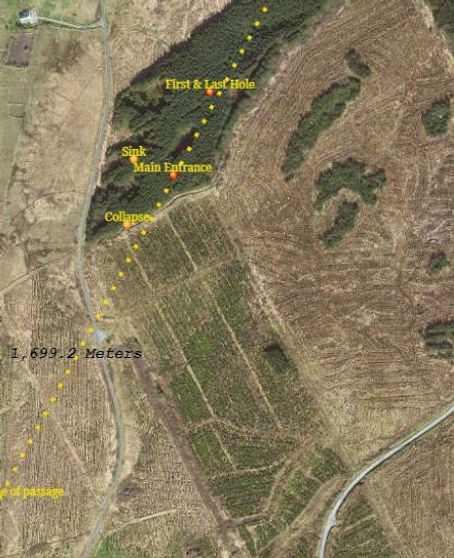
Cloud cover 90%: Wind W, F4/6: Visibility >20Nm: Showers: The Plan: investigate an old collapse. This active sink, as several depressions closer the main entrance of Cullaun II, has long been considered a feeder to the upper section of the cave. Visited the site taking GPS readings of it, the main entrance then looked for C2b sink in order to fix and reproduce the survey to triangulate the position of the collapse. This afforested area has recently been cleared; the terrain strewn with remains of tree stumps, logs and branches covering the landscape in places to a significant depth. Used a UBSS survey, reproduced 2019, walked fifty metres, slightly south of west, from main entrance, C2b was not obvious among the ground cover. After a further fifty metres, along the same direction, found an unrecorded, minor sink, in the edge of the shale boundary, now approximately one hundred metres WNW of main entrance so unlikely C2b. The timber contractors recognized the importance of natural drainage and constructed a canopy of logs above said sink, which offers accessibility to dig. Though some one hundred metres west of the main passage it is very likely a source of the stream issuing from Year Passage: but worth a rummage to see what’s there. To address the location of the reputed surface opening above the terminal pitch extrapolated the averaged passage alignment to above the area of the terminal pitch and sump one, creating a search area adjacent to habitation.
Pat Cronin


30th July Unregistered Souterrain & Souterrain CL008-130002
PC
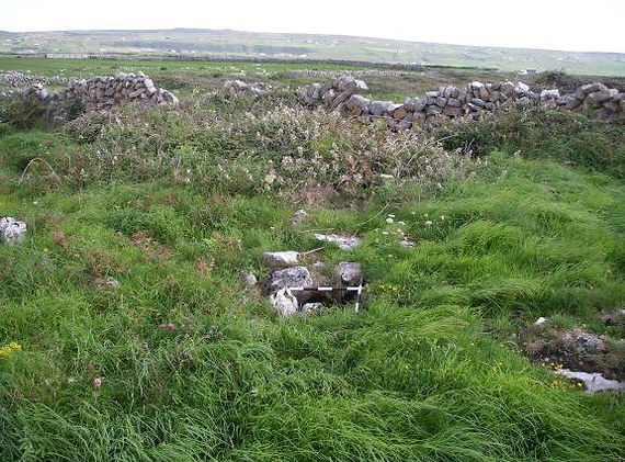
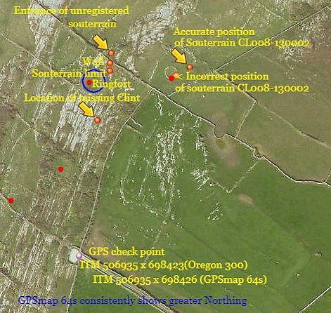
17:30. Sunny: Warm: Cloud cover 50%: Visibility >30Nm: Wind W/SW, F6. The plan: revisit souterrains in Teergonean and Ballycahan Townlands. The previous visit of 27th September 2012 with “Popeye” Boycott was curtailed when PC’s leg fell through a grass covered gap between the roof lintels of a souterrain successfully ripping 95% of the knee ligaments from their attachments. So, on return cautiously approached the location, its precise outline obscured more than before; briars successfully colonizing. This souterrain has been constructed by the removal of a Clint, some 1.2m wide, its visible length estimated at some fifteen metres; quite an undertaking. Several lintels are missing, their absence from the passage below suggests removal for house construction; once a common enough occurrence. Some lintels were estimated at 1.5m long, by 0.3m thick, by 0.5m wide; around 500Kgs. The outlines of much larger lintels are visible among the ground cover. The souterrain’s route can be traced from some five metres south of the Teergonean – Ballycahan townland wall to around ten metres within the ringfort compound, (garth) here its entrance is partly choked with limestone boulders. The opening is potentially central within the ringfort interior, though as the rampart is denuded this is difficult to precisely ascertain. Experienced the Garmin GPSmap 64s reporting “poor satellite signal”, left unit to stabilize; later found the recorded positions to be inaccurate by up to twenty metres; need return to obtain sensible positioning. Moved on to souterrain CL008-130002, some seventy metres to the east-south-east; its rampart too much denuded, likely its stone used in the construction of nearby field walls. A weather eroded hummock feature contains the souterrain CL008-130002; built upon the limestone bedrock. The souterrain passage, which follows the curvature of the mound, is visible through gaps among the exposed lintels on the weather side of the mound. This feature closely mimics the appearance of ancient burial mounds, and may have been purposely sculpted to camouflage the souterrains presence, and intent. Doolin packed with visitors; it’ll end in tears with another lock down.
Pat Cronin
1st August Unregistered Souterrain & Souterrain CL008-130002
PC
19:30. Showers: Wind W, F4: Mild: Visibility >30Nm. The Plan: return to address the dodgy GPS positions taken 30th July. Heavy showers delayed start. Took both GPS units; brought along the Garmin Oregon 300 to check the erroneous readings displayed by the Garmin GPSmap 64s. During todays usage no “Poor signal” information was received by the 64s. With a close eye on the shower approaching from the Aran Islands, managed to record the registered and unregistered souterrains. Both entrances are in Ballycahan townland: the unregistered souterrain has no registered ringfort ascribed. The passage of the unregistered souterrain begins in Ballycahan heading south into Teergonean townland; to get an estimate of its length took GPS positions of its entrance, where it passes beneath the townland wall and the general area where it terminates among foliage in the shadow of a Ringfort. Returning to the truck encountered a twenty metre length of karst where the Clint had been removed; (ITM 506952 x 698551). Was this preparatory work conducted by established settlers -farmers, abandoned owing to difficulties encountered during construction of another Ringfort? As foliage dies back each souterrain requires a survey of accessible sections. Doolin packed with visitors again.
Pat Cronin
2nd August Dig site
PC
13:00. Cloud 95%: Mild: Showers: Wind SW, F4. Itching for a walk; decided to include a look at a past, potential dig site some three hundred metres northeast of Poulnafearbui. Dropped off at Poulsallagh by Pauline, just as the rain cleared toward the northeast; diverted to take a look at S3, imagining following the recent heavy rain peat stained water would confirm the resurgence exact location, however the tide had covered the area, no staining observed. Continued south: after some ninety minutes arrived at the dig site situated in the head of a dry valley similar to Poulnafearbui, (ITM 507613 x 699813). Climbed down into the briars and bushes; managed to tear the arse out the trousers. An obvious joint heads off northeasterly, it does appear to widen lower down, could not be accurately assessed as several large boulders need removing. It’s possible these could be trundled downhill into the surrounding foliage. Walking up to the Fraggle Rock parking spot, encountered parallel walls, though only a few stone high, they appeared to edge a two metre wide track; Pat Connolan once related how along the edge of the slope to the coast he’d encountered such a track outline to the south of the parking area. Brewed up; enjoyed the cool circulating air.
Pat Cronin
3rd August Considine’s Cave, (South End)
PC
18:00. Cloud 100%: Warm: Visibility >35Nm: No wind: The Plan: Dig. Replaced the lifeline with temporary, as could not remember if original reached the present bottom; used Petzl ASAP to self lifeline. Landed among stench of death; eventually located the deceased, a large rodent. Placed same in kibble; climbed out to dispose of carcass. Cleared away two boulders, one of 70Kgs, improving the view of the slowly widening east rift. Pebbles fell for some two/three metres landing with a dull thud; removed more debris allowing an oblique view, (45°), for three metres down toward the east; clearly visible are several large horn like projections along this wider area of the rift; estimated 0.25m wide: projections appear water worn. Did not use the generator; no fuel on site.
Hours 2 (2581), Southend (1531), Kibbles 0 (5026), Nets 0 (839), Total 5865.
15th August Cullaun Two
Matt Palmer & Pat Cronin
15:00 – 17:30
Weather – Dry and warm, heavy rain 48 hrs previous, no wind.
Objective: Sport caving trip.
PC led MP on pleasant bimble into Cullaun Two following the streamway from Main Entrance to the top of the 10m pitch above sump one. It was MP's first trip into the system. Streamway was noted as flowing ankle-deep along the level chert streambed and was a black-tea or IPA in colour, presumably from tannins washed from peaty soil during the recent-ish heavy downpours. Admired the numerous stalactites in the roof and other calcite formations including the helictites approx. 100m downstream from Main Entrance. MP free climbed up to the top of the jagged rift above the 10m pitch and noted the beginning of a bolt-climb up into an approx. 1m diameter shaft bolted previously by Tony Seddon. It is suspected that there may be a connection to the surface at the top of this shaft which might allow almost direct access (by SRT) to sump one for diving. A rope was found in-situ, hanging coiled up from the bottom of this shaft.
Pat Cronin
15th August Considine’s Cave, (South End)
18:00 – 20:00
Weather – Dry and warm with no recent rain, no wind.
Objective: Dig.
MP and PC joined CC who was already at the dig getting set up. MP descended the shaft, set up comms and dug down into the floor above the southeast rift gradually being revealed. 20 kibbles were sent up on the winch and 7 or 8 full kibbles remain at the bottom of the dig to be winched out at a later date. On exiting the dig, another dead rodent was spotted behind fixed ladder at the bottom of the pitch. MP decided to leave this for PC to deal with his next visit as the last kibble had been sent up!
Hours 5 (2586), Southend (1536), Kibbles 20 (5046), Nets 0 (839), Total 5885.
Matt Palmer
29th August Souterrain CL009-022006; Lisnanroum
PC
Wind N/NW, F4: Cool: Visibility >10Nm: The Plan; continue the survey of the enclosure at Lisnanroum. Following the visit by Dr’s Comber & McCarthy on the 2nd October 2019, PC decided to produce a plan of the raised mound to attempt clarify its suggested origin; that as a possible burial mound. Significant settlements were established adjacent revered or sacred sites, supporting settlers, possible spurious claim to right of ownership of the wider landscape by association of ancestral links to those interred nearby.
Erected two tripod survey stations either side of the west and east of the north-south feature, orientating the stations with each other by distance and bearing. The majority of measurements conducted from the western plane table station. In order to locate the potential passage entrance struggled into the briar patch. Probing, using the survey staff could not feel any undulations significantly higher than the ground surface outside the briar patch; suggesting the briars obscure the very end of the mound; the possible entrance. Either way trimming these briars will expose the possible entrance area for recording. Virtually the entire enclosure’s interior surface is uneven, broken. Two common ground levels are present, commoned height difference being approximately 0.45m. Areas do exist with a cover of humus, though among this rock protrudes. One area appears specifically quarried flat, possibly in preparation for the potential house in the southern enclosure adjacent souterrain, CL009-022007. The differing levels within the enclosure suggest widespread quarrying producing material for the construction of its perimeter walls and other features. The more northern enclosure walls are of inferior build quality to that of the southern enclosure, which appears the original settlement. En- route to the enclosure, from the single track road there is an area which clearly exhibits quarry activity. Next: to survey the passage and produce profiles of the mound.
Pat Cronin

3rd September Considine’s Cave, (South End)
CM, CC and PC
Cloud 40%: Visibility >30Nm: Wind NW, F2; gusting F4: Medium stream: Ground soft: The Plan; Dig. CM digging: CC winching; PC unloading and barrowing. Retrieved the flood lamp from -18m, discovered the faulty as flooded. Physical evidence of further flooding of the shaft; the general opinion is flood water backing up from the main river route beneath the valley. The only known outflow for the Coolagh drainage is the S3 resurgence; narrow and low this bedding, about a kilometre south of Poulsallagh Bay, within the intertidal zone, needs a closer look during a low spring tide. S4, a dig, is some 200 metres inland from the resurgence and has reached a point where the upper edge of bedding was seen, down between the boulders; this could bypass the resurgence.
Once signal and comms systems were connected CM began sending up the pre-filled kibbles along with excavating from the southeast rift opening around toward the southern rift opening. A steady pace produced thirty lifts of which twenty eight were kibbles, and two nets. Delighted with the session; great to press on with it. Removed the “Rig” to oil and service this lifelining device. CM made a video to illustrate the status.
Hours 6 (2592), Southend (1542), Kibbles 28 (5074), Nets 2 (841), Total 5915.
Pat Cronin
4th September Considine’s Cave, (South End)
PC
Obtained six good pallets to replace those deteriorating within the working platform; this supply will cease soon enough.
Hours 0 (2594), Southend (1544), Kibbles 0 (5074), Nets 0 (841), Total 5915.
6th September Ancient resurgence, North of Poulnafearbui
CC and PC
ITM 507614x699812: Wind NW, F4: Visibility >30Nm. The Plan: assess a potential dig; an ancient resurgence. Using loppers descended through Blackthorn, briar and fern. Exposed the rift opening, which was found to be well choked with large boulders >80kgs; examined the rift, it appears the area to dig is directly below the obvious large rocks: stream erosion along the southeast wall is evident. Removal will require capping; at least four rocks rest upon one another. The upper area of the rift is narrow, too narrow to contemplate digging; lower, below the present floor the potential appears a little better. The gulley seems deeper to the northwest of the rift, of further interest is its pronounced channel of vegetation illustrating poorer growth, possibly due to “regular” flooding from a, (for the moment), obscured source among the dense foliage. Will return to hack a way through and inspect this area; potentially shades of Poulnafearbui, where Mark Lumley checked behind a small bush discovering a small opening which, when dug out, led into the main stream way. Walked some eighty metres southwest, following a broad, shallow surface channel to a three metre high weathered limestone terrace. No obvious sign of water having issued from its base, or anywhere adjacent in recent times. The area needs further assessment following heavy rainfall. Bars may open the 21st Sept.
Pat Cronin
10th September CL009-022006
PC
Cloud 100%: Wind NW, F4; gusting F6: Brief sunny spells: Cool. The Plan; continue survey of possible burial mound. Decided to record profiles of the mound, from the western station; encompassing the breach of the subterranean passage at the northern end, and the central section where the roof is breached; picking up the disturbed roof lintels.
Set up the new toy, a Leica L2P5G, green laser level, as the horizontal datum below which the ground surface could be replicated: this device was set up in minutes as opposed the normal hour setting up a level string. In the occasional sunlight Laser detection, at distance was achieved with a receiver accurate +/-1mm; another cracking bit of expensive kit. Green laser light is reportedly four times more visible in sunlight; using a receiver, the beam is detectable up to 80 metres. The speed of initial set up meant both profiles completed within two hours; wriggled into the north breach to install the datum for the underground survey; will need to cut away hazel growth obstructing the passage; need to clear the briars around the possible entrance.
Pat Cronin

14th September Cobden Cave, Black Ball Mine, Brunner Mine, Punakaiki Cave, NZ
MST
Today saw me at a good number of caves travelling along the Lewis highway and then up the west coast of the south island of New Zealand. The first stop was a town called Blackball. Here is a town established for it coal deposits. The mine started producing in 1893 and finally closed in 1964. The site now only has a chimney stack surrounded by scafolding and the old blower house with its stream running through it which maybe was the power source for the blower. However with on old boiler front and the concrete foundations it was more likely belt driven and powered by steam; unless that was for winching mine cars out as I also found a lot of cable and wheels as can be seen on the video at https://youtu.be/IOSMGm8U9yg. The second entrance I found was behind the blower house and walled off, possible to enter by taking a duck through the stream under the wall, however I wasn’t much in the mood so went to the other walled entrance. A small squeeze leading to a smooth incline square passage with the old communication wire holders and wooden guttering attached to the wall. This went for about 400m till it had been gradually back filled. It could possibly be dug out and made accessible again I feel.
Stop 2 was another old mine site, Brunner Mine, an historic area further down the river near the town of Stillwater. This is just the old workings with coke furnaces, machine foundations, cart bridge over the river and other buildings. The mine wasn’t accessible from the main entrance by the river and I didn’t push the blower access points but they may lead on (pure speculation). This is now just a road side heritage stop.
Hitting the west coast took me to Cobden Cave near the town of Graymouth; a small cave described as muddy on WikiCamps from where the location was found. This is a short walk down a track next to the river mouth. The cave itself only goes in maybe 150m. A stream running at the base with the only muddy bit being a tight-ish squeeze at the end which only leads an extra 2m. However a side passage leads to a good size waterlogged Passage that being so close to the river and ocean could be an interesting dive, especially with clear water and about 2m diameter passage.
The last cave of the day about an hour north up the coast next to Pancake rocks is Punakaiki cavern; a short but wide cave about 100m deep and supposedly home to glow worms though I never saw any when I was there. Not a bad stop at the side of the road with cave one side and beach the other. See video at https://youtu.be/KRRX4ydTx1g.
Mark Staples
Detailed information about this site and it's history can be found at https://www.doc.govt.nz/globalassets/documents/conservation/historic/by-region/west-coast/blackball-coal-mine-historic-inspection-and-workplan.pdf
17th September Considine's Cave, (South End)
CM, CC and PC
Warm sunny evening, light wind. Ground dry with little rain in the preceding week:
The Plan; Dig. CM digging: CC winching; PC unloading and barrowing. CM descended and began sending up the pre-filled kibbles. The focus for the dig centred on levelling the floor at the southern side and extricating a large boulder from the SE rift, it having being netted on the previous occasion. The footprint of the digging face is now a rough figure of 8. The northern circle has a diameter of 2m, the southern circle a diameter of 3m. Once the Boulder (approx 90kg) was removed, efforts were concentrated on the SE rift. Upon removing loose gravel from this corner it was possible to hear stones and rocks cascading down further for 2-3m into a void below. A steady pace produced thirty kibbles, and two nets. Remaining at the dig face: nine full kibbles.
Hours 6 (2598), Southend (1548), Kibbles 30 (5104), Nets 2 (843), Total 5947.
Cathal Mullane
19th September Considine’s Cave, (South End)
PC
17:00. Cloud 60%: Visibility ≤20Nm. Small stream: Ground becoming firm: The Plan; attend busted flood lamp. Fashioned a “lampshade” from a 25 litre plastic container, to shield the replacement light fitting; wired same. Obtained ten litres of fuel; filled generator: five litres spare on site.
Hours 2 (2600), Southend (1550), Kibbles 0 (5104), Nets 0 (843), Total 5947.
Pat Cronin
21st September Considine’s Cave, (South End)
CC, Kate Lavender-Duncan & PC
Cool: Cloud 100%: Visibility ≤30Nm: Wind WSW, F4, decreasing: Small stream: Ground drying. The Plan: Dig. The Team were joined by Kate Lavender-Duncan; a potential regular. KLD descended; at the bottom PC explained the importance of observing the array of safe hauling/working practices and phone system. PC ascended. Winching began 18:55. CC winching: KLD digging: PC unloading and barrowing. KLD began extending the hollow in the southern end northward creating a level floor area. No obvious draught tonight from the southeast rift. KLD is a swift learner, enthusiastic and safe; producing a trouble free twenty five kibbles of assorted rock, clays and gravels. K.L.D., (Kate Likes Digging?) asked to attend regularly, Monday is her free evening; delighted at this prospect. The new light fitting works well: illumination a 100w, LED bulb. The extant junction box presents an issue when pulling the light up through the timberwork; ideally a longer, replacement cable required. Generator 7/8ths full; five litres spare on site.
Hours 6 (2606), Southend (1556), Kibbles 25 (5129), Nets 0 (843), Total 5972
Pat Cronin
24th September Considine’s Cave, (South End)
CC, CM, PC
Cold: Cloud 10%: Wind NW F4/F6: Visibility ≥30Nm: Small stream: The Plan: Dig. PC trundled two pallets across the field as replacements for potential dodgy ones on the working platform. CM digging: CC winching: PC unloading and barrowing. CM gradually excavated the face northward, dealing with the curious assemblage of boulders within the narrow area, before the danger area. A number of large boulders are now evident at the dig face, including one well over 100kgs. Another smaller boulder blocks a promising lead into the south eastern rift. Once again with three on site not one was idle, the steady, constant pace producing six very heavy nets, and nineteen kibbles of assorted clays and cobbles. The spoil is being deposited onto/into the boundary of Jonathon’s field; cobbles etc. are being placed along the northern boundary wall, up to the hedge, this edging includes clays to help “bond” the mass together whilst it will also have a batter to improve stability of its face. As if in sympathy one piece of a pallet broke tonight; this needs attention, ASAP.
Hours 6 (2612), Southend (1562), Kibbles 19 (5148), Nets 6 (849), Total 5997.
Cathal Mullane
26th September Considine’s Cave, (South End)
CC, PC
Cloudless: Cold: Wind NW, F2: Visibility >30Nm; Small stream: Ground firming: The Plan: replace the broken pallet. PC trundled a fourth pallet across to the site; this leaves three at the bottom of the trackway, with a spare on site. Reviewing the removal decided to replace two of the adjacent pallets; doing so threw up several issues as the 20m fixed ladder has its topmost fixings secured within the central pallet frame, as does the lifeline system. Removal of the three pallets produced a dark, gaping maw; CC took photos. An inspection of the platform joists, constituting the frame on which the pallet rests, revealed no rot present in any of these well preserved timbers; sourced from “Popeye” when he demolished his fencing. Though unplanned, therefore not having the requisite tools, the expanded project was completed successfully. The platform is finished and lifelining system fully operational; ready for the next session. Some debris fell into the shaft; highly probable the “Plank” will need cleaning - clearing of any potential missiles.
Hours 6 (2618), Southend (1568), Kibbles 0 (5148), Nets 0 (849), Total 5997
Pat Cronin
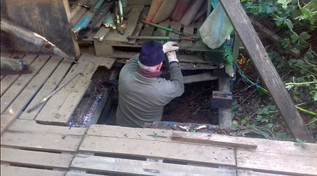
Removing the first pallet by destroying it first
_JPG.jpg)
With a 20m+ drop below, the pallets need to be sound

Second pallet removed showing the main bearers
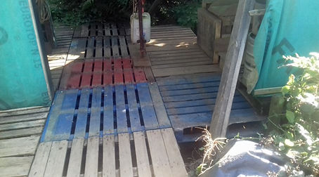
Job done for the day. Two Blue and one red
27th September Considine’s Cave, (South End)
PC
During yesterday’s session discussed availability of decent pallets. CC rang later to say Peter, at the Roadside, had several. Found five; loaded up, and delivered them to the stack on the track, near the dig. Sum total available now nine; each of good quality. Need change oil in the generator; fuel tank ¾ full; spare fuel on site.
Hours 1 (2619), Southend (1569), Kibbles 0 (5148), Nets 0 (849), Total 5997
Pat Cronin
28th September Considine’s Cave, (South End)
CC, PC
Warm: Cloud 80%: Wind W, F2: Visibility <20Nm: Small stream: Ground soft of firm:
The Plan: replace two more pallets. Yet another pallet was trundled over, this, and the spare, were inserted into the barrowing route; a further three, adjacent the boulder spoil wall, need be replaced soon. Regular maintenance completed the session, ready for Thursday. Need to change oil in the generator; fuel tank ¾ full; spare fuel on site.
Hours 2 (2621), Southend (1571), Kibbles 0 (5148), Nets 0 (849), Total 5997
Pat Cronin
30th September Considine’s Cave, (South End)
CC, CM and PC
Cool: Cloud 70%: Wind NW, F4: Visibility <25Nm: Medium stream: Ground wet: The Plan: Dig. CM digging: CC winching: PC unloading and barrowing. CM continued to work northward, toward the hauling zone, levelling the floor surface. This produced thirty five lifts of which nineteen were kibbles and six heavy nets, a net averaging 100/120kgs. The South east rift, while still partially blocked by a small boulder, continues to be of interest: around 6m of open passageway is visible descending at around 20degrees from vertical. A very large boulder ~120kgs sits just above the slope into the rift and will need to be dealt with soon. Issues arise in the spoil area; the meandering, upslope approach becoming telling; will likely breach through the bank, on the west boundary, to deposit spoil beneath the copse canopy, creating a less strenuous route. Generator a little over ½ full: five litres on site.
Hours 7 (2628), Southend (1578), Kibbles 19 (5167), Nets 6 (855), Total 6022
Cathal Mullane
Or