Pegasus Caving Club
aka Pegasus Club Nottingham
4th July L118, Poulacapple Project
PMcG, PC
11:00: Cloud 100%, base 70ft: Wind SW, F5/F 7: Visibility 2Nm: Temp 15°C: Gauge 0mm: Ground wet. The Plan: Dig. Picked up PMcG at Gragan’s Wood (ITM 519145 x 701600). Grim weather conditions kept the turf footers away. PMcG descended to review progress, handing up bits of ‘Benny’ to clear the area, the pieces used to continue building the neat wall east of the depression. Continued lifting more spoil, clays and small rocks. Changed places, split the two large boulders using P&G’s, depth noticeably increasing. Substantial amount of clays and rocks had collapsed from beneath the ‘pinned’ boulder, covering the previous weeks view. Another boulder was uncovered, and dismantled; its neighbours too - offering a clearer view of the southern side bedrock, and unstable, compacted debris above. This overhanging face needs shoring, to avoid injury when emptying the developing rift feature below. More stone, clay and rock removed, achieving a further metre of depth – exposing three holes, each with darkness beyond, and bedrock exposed on the west side. Spoil area behind the western shoring at its limit. The bedrock converges forming a rift, its gravel floor, around a metre, or so, below the present dig invert, seemingly heading SW- ish. No light, so a clear view into the voids was inhibited. Had tea, out of the gale, and rain. This situation requires infrastructure, to contain the dodgy area and facilitate hauling, not least create a small working platform, both diggers a target for small pieces of spoil during hauling. Intend allow exposed area to ‘stabilize’, say a few weeks, in the meantime shift operations to L199, (Dig) and L200, (possible open passage), purchase galvanized scaffold tube, convey it and scaffold clips to L118, en-route to the southern sites, to reduce ‘down time’. PMcG took photos. A Crackin’ session.
Pat Cronin

View north-east of entrance shaft

P.C. drilling holes for plug & feathers
12th July L118, L199 & L200, Poulacapple Project
PMcG, PC
11:00: Cloud 15%: Wind E, F3/5: Visibility 20Nm: Temp 30°C: Gauge 0mm: Ground drying. The Plan: L118, L199 and check L200. Met at Gragan’s. Previously prepared five lengths of Scaffolding (1 x 1.4m, 1 x 1.6m, 3 x 1m), and ten clips, all dropped off at L118. Descended to double check tube lengths required. Inserted the 1.4m horizontal tube in place, four braces are needed 1 x 700mm, 1 x 800mm and 2 x 900mm, fixings need be 8 swivels. 2 x 1.25m needed for a secure ‘stance’ for hauling, fixings 8 x 90’s. Also needed; Hilti, batteries and 3 x 16mm galvanized studs. Presently ‘spare’ on site is 1 x 1.6m and 0.9m tube lengths. Headed to L200, in increasing temperature. This partly filled, narrow rift would repay digging, plenty of room for spoil among this tree covered, four metre deep, pear shaped depression. At L199, disappointed to encounter a minor fall of soil, which obscured the entry to the low bedding, though a good bit removed the site does now need two kibbles and tools. Headed to Nagle’s for cool drinks. PMcG contributed 50 euro toward materials.
Pat Cronin
1st August L118, Poulacapple Project
PMcG, PC
10:30: Cloud 75%: Wind W, F3/4: Visibility 30Nm: Temp 20°C: Gauge 1mm: Ground drying. The Plan: Install shoring. Carried in 4 x 1.5m lengths of galvanized scaffold tube, Hilti, Mini-grinder, scaffold clips, etc. PC began assembling the main frame - braced off the north wall, utilizing the southern central, horizontal cross member in the shaft. 4 x vertical tubes installed, to be backed by steel sheet, ensuring minimal, future issues from large and small overhanging boulders or drying clays. PMcG descended to complete the installation. After, PMcG destroyed the large, previously pinned boulder using plug and feathers. From where a direct, vertical line of sight is available to the top of the lower rift, the potential pitch, that may require improving hauling, should the need arise. The stream channel, visible through the holes in the western side of the shaft, is the likely drainage from the curvi-linear line of depressions L115–L117. The situation now requires a hauling frame, off which to employ mechanical advantage; 2 x 16mm holes were drilled in the face, above the shaft, to secure installation, the central location will permit the frame to be readjusted as required.
Pat Cronin

View south-west

View south-east
8th August L118, Poulacapple Project
RD, PMcG, PC
10:30: Cloud 50%: Wind SW, F3/4: Visibility 30Nm: Temp 23°C: Gauge 0mm: Ground dry. The Plan: Install infrastructure - Dig. Supported by RD, conveyed seven differing lengths of aluminium - galvanised scaffold tubing, more scaffold clips, mini-grinder, bits, tools etc. to L118. Whilst PMcG descended to install protective metal sheeting behind the sloping scaffold, directly above the rift, RD, and PC assembled the hauling frame. Extant straight connectors did not fit the internal diameter of the Aluminium tubing - external type required from stock. Cobbled together the general design of the hauling frame to see what else might be required. Assembled the narrow working platform; realised had left the galvanised turnbuckle in the workshop. Installed open boarding to the southern shoring, temporarily secured in place by cable ties, this will be backed by flat, galvanised sheet. PC investigated the wet, cracking clay face of the lower western wall: cautiously poking it, it slumped, landing behind a now loosened elongated boulder. Cleared the remaining clay and three boulders, each rock reduced enough to fit into the kibble, which RD hauled to surface, and PMcG deposited behind the dry stone wall, created from spoil. The area now exposed below the western shoring limit is a tight jumble of medium, large, and a massive rectangular block peeking out from the mass above it, this part estimated at 240kgs, it slopes 20°’s down toward the rift. Ideally this requires bracing, as, should it slide it is narrow enough to drop into the proposed excavation of the rift - bedrock is either side. If the existing brace is relocated slightly westwards, directly above the intended boulder brace, then from these two braces, verticals could be fitted, behind which stone spoil could be backpacked. To the north of the massive block a crack between it, and now confirmed bedrock, was cleared to where clean washed stones, and smaller gravels were encountered; all removed to surface. Measurement taken for timber-work, and associated shoring supports. Tea and Medals in the sun, then pints in Nagle’s. A cracking session, much achieved.
Pat Cronin

Paul McGrath and Roger Day at the L118 Dig Site
9th August CL008-001004, Souterrain, and CL008-002001, Court Tomb
RD, PC
12:00: Cloud 100%: Wind SW, F3: Visibility 10Nm: Temp 17°C: Gauge 2mm: Ground dry. The Plan: Research – tourist trip. Discussing the souterrain project with RD, realized needed to check on the depth of bedding in the exposed terrace to the west of CL008, sub-square ringfort, cashel. Showers fading. High summer vegetation made walking to the sites problematic. Court Tomb first, found recent clearing a bonus, the two chambers equally visible. Crossing to the souterrain; rough ground surface presented minor issues. Noted encroaching Hawthorn to the northern, and eastern denuded ramparts. Little evidence of recent grazing. Approaching from the west, in the narrow, limestone corridor, ascending to the cashel, noted several beddings extending to almost three metres of depth below the surface of the cashel above. Delighted at the number, supporting one hypothesis of souterrain construction. Arrived back at the motor, missing the car keys, found them at the base of the terrace. Into McDermotts for pints.
Pat Cronin
10th August Kilfenora, Noughaval Hole, Cahermcnaughton
RD, PC
10:30: Cloud 30%: Wind SW, F2: Visibility 15Nm: Temp 23°C: Gauge 2mm: Ground dry. The Plan: tourist trip – research. Penultimate day of RD’s visit: archaeology and attempt, again, to locate a rumoured hole near Noughaval Church. Enroute, encountered contractors, enquired of ‘spare’ steel braces, rewarded with three: delighted. Pleasant time spent around Kilfenora, then to Noughaval. Chanced calling on DH, who kindly pointed the team to the ‘Blessed Tree’, beneath which the hole is said to be. Landowner and address obtained – more delight. Found the area beneath the tree a large, thick bed of nettles. Need call to PH to obtain permission. DH also suggested speak to neighbour Tessa, steeped in local history, the Priest also officiates at Ballyvaghan. To Cahermcnaughton Cashel; a school of Brehon Law, impressed with its dimensions, gateway fortifications, internal diameter and boulders used to construct the face of the rampart - regular rocks averaging 250kgs noted.
Pat Cronin
14th August Gleninagh South Cave, Gleninagh Pot
PMcG, PC
11:00: Cloud 100%: Wind W, F2: Visibility 30Nm: Temp 21°C: Gauge 1mm: Ground dry. The Plan: review as a potential dig site. Met near Nagle’s Bar, drove to the coast, via Kilmoon, parked at ITM 519045 x710032. Ascended the path, directly opposite, to the obvious stile at ≈225m elevation, turned east, following a townland wall, and part of the ‘Burren Way’. Route markers are some 100 metres apart, clearly visible. This route ascends three significant limestone terraces. Above, in the distance, is a four metre square limestone faced water tank, Gleninagh South Cave is half way down the obvious dry stream channel, some 100 metres NE. The shaft and fill is not as remembered. The angle of the boulder/scree slope lends itself to digging, by means of a Tyrolean; with spoil deposited outside - large boulders are present. Some evidence of cattle on the slope opposite the entrance, boulders immediately outside the entrance, seem arranged to inhibit the more curious of cattle: were digging to take place a decent stock barrier would be both respectful and appropriate.
The bottom back wall is near vertical, though may, perhaps, incline south, beneath the boulder slope. Assessing the surface channel, it may be that the invert of the channel is not too far beneath the accumulated entrance slope debris. The upper passage in the rear of the pot, is all but level with the outside ground surface, suggesting an earlier period of development. It wants looking at, requiring an awkward climbing. Up on the terrace, some twenty metres NE, encountered a pot, four metres deep. PMcG descended, finding it 0.9m diameter in solid rock, with fist sized angular stone floor, an easy enough dig. The farmer is unknown, but agricultural infrastructure suggests someone has perhaps lost stock on these precipitous northern slopes.
Gleninagh South Cave, ITM 519311 x 709281. Gleninagh Pot ITM 519330 x 709290. The ITM published for Gleninagh South Cave is in error, shown some 100 metres to the NE.
Gleninagh South Cave was one of several local sites dug in the 1970s by, at least, Jim Shannon and Noel Walsh. Whose knowledge was sought by PMcG, prior to this trip.
Pat Cronin

OS map of investigated area

Aerial View of investigated area

Gleninagh Pot

Gleninagh South Cave
15th August L118, Poulacapple Project
PC
10:00: Cloud 100%: Wind NW, F2: Visibility 20Nm: Temp 21°C: Gauge 0mm: Ground dry. The Plan: complete hauling frame. Carried in 2 x 2m lengths of galvanized scaffold tube, 2 lengths of ‘Popeye’s’ 4x2, scaffold clips, tools etc. Timber left at the enclosure. Stripped the old frame apart, built a new design, from off the shoring frame, working platform and adjacent rock face, laterally secured with stainless steel cable and galvanized turnbuckle. Repositioned a vertical board to the west end of the southern shoring, the gap now created can be filled with 2 x 6 foot, 4x2’s, backed with the galvanized flat sheet – this will contribute to protecting those digging below from potential movement of the disturbed ground. Extant digging rope only ten metres - requires replacement. Pulley and bracket secured to cross brace, likewise mechanical advantage anchor.
Pat Cronin
23rd August L118, Poulacapple Project
Peter Ward, PC
12:30. Cloud 60%: Wind W, F32 Visibility 30Nm: Temp 22°C: Gauge 0mm: Ground damp. The Plan: Install brace support to large boulder. Picked up PW from outside Nagle’s, visiting to experience some factors involving digging, and shoring. Carried in Hilti, mini-grinder and a few other tools. Sent PW down to observe the features of the dig, presently some -4m below the invert of the depression. Changed places with PW to figure out where best to secure the brace. During which, noted a large boulder, or actual bedrock, to the SW, below the western boarding. Decided to secure the brace some halfway down the projecting ‘nose’ of said boulder. Just enough room for the drill and bit to fit into the rift gap. PW lowered the kit than joined PC in cramped conditions. Noted further, minor, subsidence at the eastern end of the rift, providing a view down through small boulders a further metre, may have a gravel/stony bed. Took PW through the process of fitting a brace, involving assessing the area, choosing a place, drilling the holes and cutting the galvanized tube to an accurate length, he did well. Its tempting to install two vertical tubes, between the boulder brace and the shoring brace, behind which to stack ‘deads’, assisting to laterally jam the large boulder, and support the exposed boulder face beneath the western shoring. Ready to dig. Need a longer rope.
Pat Cronin
29th August L118, Poulacapple Project
PMcG, PC
10:30. Cloud 70%: Wind W, F2 Visibility 25Nm: Temp 23°C: Gauge 4mm: Ground wet. The Plan: DIG. A lightweight walk-in, Tea supplies, and a rope. PMcG to below to review progress, and start digging. Some eight, or so, kibbles raised, along with a destroyed boulder, exposing several large rocks. Changed places. Successfully applied the sledge to a lump shaped like an anvil, of similar weight. More medium to small boulders and angular stones, and some clays. All spoil deposited within the specifically built, neat drystone area. Depth was gained swiftly, conservatively a metre. Changed places. More of the same: large – medium – small boulders, with assorted small debris. At end of three hours, had exposed an undercut, at the centre of which is a water worn gap in the ‘cheek’ of bedrock dividing the dig and rift beyond. The ‘cheek’ is completely undercut, the floor of loose, clean washed debris. Left, the debris slopes down to the east, to the right, beyond, under the ‘brace’, the top of a waterworn, clean washed, scalloped radius is clearly visible, some 1.2m in diameter, above, and to west of this, a cluster of water worn flags of limestone, are seemingly, securely, jammed vertically in position. Suggesting a roomy area to dig. A thick, finger of bedrock extends some 0.9m from beneath the west wall, behind which is a water worn, clean washed cavity, likely once part of the northern wall, this needs removing to facilitate digging. There appears another protrusion directly below the ‘Finger’, which may also need removal. Intend to P&G the ‘Finger’ in two places along its length, as its exposed length might exceed 100Kgs. Both pulleys gave issues, from a muddy rope, compromising the grip required heaving boulders, even on a 3:1. So, need specific, clean gloves for hauling only. Discussed access, some form of ladder needed, toes of muddy boots aren’t great on 2 inches of muddy scaffold bar. Hauling from this future location, some offset from the hauling line centre, might be problematic, some form of channel might direct the kibble around this potential 1.5m offset. PMcG unavailable for two weeks. A really crackin’ productive session.
Pat Cronin

Undercut into rift beyond
4th September L118, Poulacapple Project
PC
12:30. Cloud 95%: Wind W, F5/7: Visibility 20Nm: Temp 17°C: Gauge 17mm: Ground sodden: Heavy showers: The Plan: Dig. Carried in Hilti, P&G’s, short lengths of scaffold tube, clips, etc. Tried out a 15mm drill for the P&G’s, rather than 16mm, works well. Drilled two sets of holes, half way along the ‘Finger’ and where the ‘Finger’ emerges from beneath the large boulder. Took longer to drill the holes than severing it into two pieces. Nice listening for that satisfying ‘crack’, seconds after driving the P&G’s into a ‘tight’ situation. Stacked the pieces, temporarily, above the adjacent brace, immediately drilled and cleaved off the ‘Nose’, situated directly beneath the ‘Finger’; their removal producing a comfortable area, (0.8m wide), from which to work to lower the floor to pass beneath the ‘check’ of the wall, into the area some 1.2m wide. Below the ‘Finger’ the north wall steps back some0.3m, appearing vertical; thrilled. Drilled a 15mm hole into the western bedrock to take a vertical scaffold tube stud, off which to set rungs facilitating access. Stripped apart the upper head frame, redesigned the crosshead permitting future readjustments of hauling position. Replaced rope added a deviation pulley and jammer. Rope supplied by PMcG, (20m?), brought the old rope back to clean. Need more kibbles, not too large, so can be carried up out of the depression two at a time, to the spoil area. Delighted.
Pat Cronin
6th September L118, Poulacapple Project
PC
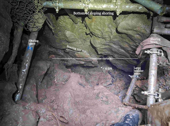
10:30. Cloud 100%: Wind S, F4/5: Visibility 15Nm: Temp 20°C: Gauge 0mm: Ground wet: Showers: The Plan: complete preparations prior to return of PMcG. Carried in sheet of galvanized steel, large kibble, short length of scaffold tube, etc. Slid the sheet steel vertically between the southern shoring closed boards and suspended ground, closing the small opening at the top of the sloping shoring, this needs final checking, the remaining gap can be back filled, on the basis the dig is entering the realm of bedrock, on at least three sides. Descended to create a sequence of useful rungs. Encountered a minor slump of very wet grey clays having collapsed from the area behind the suspended western shoring lower limit. Had to drop the three stacked boulders onto the floor below to reach the previously drilled hole to insert the location stud for a vertical scaffold tube. Cleared more clay, packing it into adjacent gaps. Began creating the rungs, the present vertical tube is too short, needing an additional length. Noted dig is short of scaffold clips, need more – attending to the slump, secured the base of the vertical tube to the upper brace, installed another vertical between both braces, off these can create a suitable containment to support the exposed area. Ran out of clips, need 12 x putlock and four swivels. A poor quality compass bearing was obtained, ≈115° Mg, (south of east), viewed obliquely, (45°), along this bearing, a further 2 - 3 metres depth is clearly visible, through loosely packed boulders. Separating the dig and the significant cavity beyond is a limestone curtain, terminating ≈0.3m above the floor. Beyond the curtain the area is, at least, some 1.8m long and 1.2m wide, at its upstream end is a partially obscured, semi-circular waterworn radius, with scalloping. When the floor is lowered the total passage width may be 2metres. From the look of the floor, and visible potential depth, it may be loosely filled inclined passage. Rejigged the hauling anchors to clear the shoring. Carried back materials no longer required. Need clips and maybe four short lengths of scaffold tubing. Delighted.
Pat Cronin
Awaiting your next log please. "Remember, if it's not written down it never happened"