Pegasus Caving Club
aka Pegasus Club Nottingham
3rd April L118, Poulacapple Project
PC
10:00: Cloud 100%, base 800ft: Wind W - NW, F6 gusting 8: Visibility, 0 - 20Nm: Rain Gauge 26mm, Heavy showers: Temp 11°C: Ground awash. The Plan: retrieve short, wooden ladder from Poulacapple Pot – see effects of 26mm rainfall in the previous 24 hours. Arrived in 10m visibility. Poulacapple Pot stream clearly audible from the surface, found a massive torrent – other surface drainage cascading from above the ‘dam’ area, straight down the shaft, a descent, or ascent, challenging in such conditions. Had an idea of further digging. Collected the short ladder, positioned both, 1.5m x 1m x 2oomm steel mesh sections across the route to the entrance - as a precaution. Carried the ladder to L118: an effort - noting, en-route, every hollow brim full of rain water. NE surface slopes running with water. Ladder perfect length, for the present depth, multiple small trickles draining to the dig, clay face appears stable. Dug a small channel to drain the pool forming in its base – removing clays, and rocks, exposed water worn rear wall underneath the bedrock face; delighted to see the previously noted dark area semi – circular in shape, water worn, and almost vertical. The formation suggesting digging may move down and right, under the outer bedrock face. Some shoring will be required, pursuing this semi-circular, vertical feature. The rear, eastern wall, of this undercut is solid, the stability of the dug semi-circular clay face requires constant monitoring. As to how deep bedrock is below the present clay bottom of the dig, is pure guesswork.
En-route to the motor checked in on L119, here PMcG believed he could hear the encouraging, distant rumble of a stream – today, wind noise prevented any confirmation. At L120 found a sizeable stream sinking into the opening, plenty of noise issuing. Delighted.
Pat Cronin
5th April Poulacapple Project, ( L199 – L209)
PC
11:00: Cloud 70%: Wind SW, F6: Visibility, 30Nm: Rain Gauge 5mm: Temp 9°C: Ground awash. The Plan: Prospecting/ exercise extend project area SE, beyond the Cairn. Considering the carrying in of shoring materials etc. looked for a decent, more direct route through the bog, found a decent route, emerging adjacent the enclosure, some 100 metres NE of the Cairn. En-route noted a choked sink - found had picked up wrong GPSR, twat, no batteries, no Map Ref. Clear views down the northeast slopes obscured by extensive swaths of shrub and bushes. Encountered a townland wall bordering Poulacapple with Cahermacun, crossed it adjacent two humps, potentially prehistoric burials? - unsure if the ground beyond belongs to JH, need ask. Followed the crest to an area of irregular shaped, (ruined), stone walls, with trees to the NE, from here the 30 odd degree slope descends, though visibility opens up, actual features of the slope remain invisible among the ground cover. Descended to a vague shape, among the grasses, found an elongated feature, two deep shakeholes, separated by an elevated area, 6m deep x 18 metres long x 8m wide. There followed a succession of deep shake holes up to 10m deep. Attempted record the sites in photos, alas, all look much the same. Used the mobile to record a map ref, but could not save the reading as a screen shot. Managed to record one, ITM 519337 x 703983: this needs checking. Stumbling around the sodden slopes, found an elevated area to better view these sites - of the ten, maybe six form a linear feature. Further wandering found another three sites. From the larger of the shakeholes, looked up to the crest, where a section of limestone cliff face, at the head of a shallow gulley, suggests a possible, long buried resurgence. Had a go at taking a video of the linear feature. The wall near the end of this linear feature is another townland boundary, bordering Gragen West townland. Beyond, believe can see a continuation of the line of shakeholes – depressions, heading south; 300 metres to the SW is the location of Green Stream Cave. Several of these steep sided shakeholes will require a ladder. Delighted.
Pat Cronin
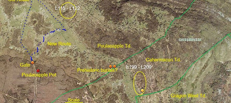
Aerial view showing sites L115 - L122 & L199 - L209
6th April L118, Poulacapple Project
PMcG, PC
10:30: Cloud 95%: Wind SE, F4/5: Visibility, 20Nm: Rain Gauge 0mm: Temp 10°C: Ground sodden. The Plan: Dig. Used the alternate route, 300m shorter, some areas drier since yesterday. Found a collapse of the clay face: hence the need for monitoring. PC began clearing the area, PMcG hauling. Steady downward progress through multicoloured clay strata. Moved the collapsed vertical flagstone into the horizontal position at the base of the clay face, will shore up against this base. Suitable stones were also used to face the clay, Reviewed the area, began to clear underneath the hanging ‘70kg lintel’, exposing large, dark gaps. Water worn rocks replaced clays. PMcG exposed more of the descending cavity, clear view obstructed by fallen boulders. East wall is bedrock, unsure if the far right wall is? Immediate right, west side, is collapsed boulders; large, medium and small - flat, and irregular. One large vertical flag lay along the passage - needs removal. Two metres ahead the lower part of the ‘vertical’ walls does not seem to widen. PMcG suggests the way may be straight down, where the dig is. If so shoring is certainly required, to permit work, and prevent clay/top soil collapse. Thirty three kibbles removed. Enjoyed Tea and medals, delighted.
Pat Cronin

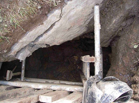
Paul McGrath at L118 'Stiking a familiar pose'
10th April L199 – L209, Poulacapple Project
PMcG, PC
10:30: Cloud 100%: Wind S, F6: Visibility, 15Nm: Rain Gauge 5mm, light rain: Temp 8°C: Ground awash. The Plan: assess/record new sites. Carried in some materials for L118, left at the enclosure. Weather quite grim. Followed crest south to just south of a much denuded enclosure, ITM 519255 x 704030, noticeably below this point is L206, an elongated, kidney shaped shakehole, with two ‘holes’ in the base, eight metres apart. PC began recording GPSR waypoints of the sites, whilst PMcG descended L200, another elongated shakehole, colonized by tree and shrub, with a bedrock face, and opening, at its southern end. Linked up with PMcG at L199. Used the handline, deployed by PMcG, secured to part of a Victorian iron bed frame. PC began clearing moss etc. exposing loose stack of washed boulders. Steady progress emptied the entrance almost two metres below the invert of the shakehole, PMcG cleared even further, to where constricted view was available into a promising dark cavity?? Difficult depth conditions, for short legs, cleared about 1.5 tonnes of boulders – smaller stone, clay and gravels yet occupy the bottom - a small kibble is required. The boulder spoil deposited neatly within the shakehole in a small hollow. A minor fall of soil and stone occurred - expanding PMcG’s experience regarding the joys of digging. Almost the entire entrance walls are bedrock, on top of which is some 0.6m of soil knitted together with plenty of roots systems, above, steep sides ascend to the surface. Will leave this hole for a week or so to monitor stability of surrounding soil. Soaked and cold - unconducive conditions for enjoying Tea and Medals, headed for the motor. Look forward to a summer on this summit.
Pat Cronin
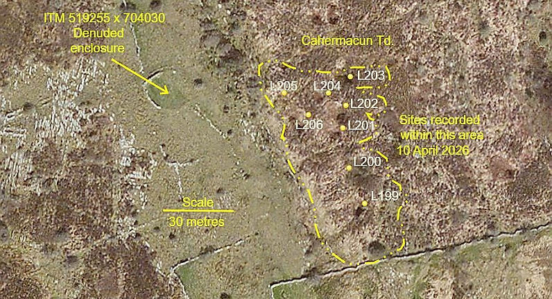
Aerial view showing location of sites L199 to L203
13th April L118, Poulacapple Project
PMcG, PC
10:30: Cloud 70%: Wind S, F2: Visibility, 30Nm: Rain Gauge 3mm: Temp 9°C: Ground awash. The Plan: convey materials – prepare for shoring. Met at Gragan’s. Carried in scaffold clips, one 1.5m length of scaffold tube, tools, Hilti, screws etc. Shuttle trips across the moorland moved all new, and existing materials to L118, a significant amount conveyed by PMcG.
Primary issue, shoring an unstable clay face. When last viewed, PMcG thought the way on might be straight down, to accommodate this possibility cleared most of the previous stone. Repositioned the large flag behind the line of boards, five driven in vertically by PMcG, held in place by PC - two of which showed some sideways travel caused by hidden boulders within the clay, clearing a boulder to allow another board to be driven, a small hole appeared, unsure if the edge of rock is a large boulder or bedrock – adjacent 15kg boulders obscure an accurate assessment. Vertical boards in position, secured lateral timbers on which rested scaffold tubing. Installed three braces between lateral scaffolding and east wall, bedrock, one is presently timber owing to insufficient scaffold tube, 1 x 750mm length required, scaffold clip in place. Began to back fill the space between open boarding and clay face with assorted sized stone, encouraging drainage. Once final scaffold brace fitted, can use this to open board the 600mm wide north clay face. A review confirmed much of the visible boulder floor consists of large, ‘thin’ flags - such will break easily with the short sledge - ‘handballed’ to surface. Remaining clays will need a second small kibble. It might be useful to fit a simple, scaffold hauling frame, as the depth assessed below the boulder strewn floor may drop a metre or so quite swiftly, making handing up spoil an unnecessarily, difficult process. Will pick up more scaffold tube before Friday. Tea and Medals in the sun. En-route home spoke with a neighbour of JH, he understands JH has land stretching over and into Gragan West townland, if so, may not have to seek a further landowner. A superb session.
Pat Cronin

Paul Mcgrath posing with the new shoring
17th April L118, Poulacapple Project
Paul McGrath, Ceily Sudell, PC
11:00: Cloud 100%: Wind SW, gusting 7: Visibility, 20Nm: Rain Gauge 11mm, Showers: Temp 10°C: Ground awash. The Plan: Dig. Ceily arrived at Carnane - met PMcG at Gragan’s. Fall of clay behind the shoring, formed a significant undercut. Rainfall had washed out a lot of gaps between the boulder floor. Protruding shoring timbers were expected to create issues with hauling, today, an awkward two stage affair. With the final brace installed, PMcG descended to clear clay to expose beneath. Resorted to filling the small kibble with spoil, handed it up on each occasion, is a real pain, CS carrying the spoil from the depression up, out to the field area – only for CS progress would not have been so significant – a system needs sorting. Steady work by PMcG exposed more boulders and removed several big buggers. PC probed various boulders in the floor – becoming bothered by the stability of the ‘southeast end’. Removal of clays, small stones and a few big boulders exposed a huge rectangular boulder, ‘Benny’?, the amount visible, cautiously estimated around a tonne. Sloping down to the NW, across the line of the vertical shoring, it may serve as a useful support, being situated at the edge, forming in part, the descending space, presently obstructed by the large vertical, jammed flagstone. Careful removal of the debris in the SE end, exposed a number of ‘secure’ boulders, some carefully removed, to see what this area consists of, doing so further exposed more boulders, most seemingly jammed. The large, vertical flag, facing the dig, was partly broken up, with lump hammer and chisel - done to prepare for another level of bracing, close to the present bottom extent of the shoring. The overhanging boulder, thought rectangular, is in fact a much larger boulder, this needs bracing. Four pieces of shoring timber need be slid between the SE face and braces, this will protect the operator in the cramped conditions, should anything choose to move. With removal of much of the boulder floor the depth is now two metres, lifting30kg boulder became an issue. On clearing loose debris from the floor below the large flag, stones were heard to fall away: depth estimated a metre. It may be best to also shore the NW clay end - drop the floor between the massive boulder, ‘Benny’ and the eastern wall, in an attempt to pass beneath the large flagstone. Benny’s mass would complement extant shoring. Showers had amalgamated, constant rain dissuaded the team to stop for the tea and medals. A crackin’ day out.
Pat Cronin
20th April L118, Poulacapple Project
PC
11:00: Cloud 90%: Wind E, 4: Visibility, 35Nm: Rain Gauge 0mm, Showers: Temp 10°C: Ground damp. The Plan: Stabilize boulder. Carried in Hilti drill, spare battery, drill bits, lump hammer, prefabricated rebar pins. No rain these two days. No puddles anywhere, the extensive boggy area significantly drier, no water covered the bedrock area. Set up, drilled down through the overhanging boulder into the bedrock beyond at a 45 ° angle, using 10 and 16mm drills, inserted prefabricated rebar: pins are loose fitting, being of 12mm diameter. Being loose, they may be ‘turned’, occasionally, to check for movement. Need to look at replacing a battery, circa 400 euro? Descended the handy ladder to measure materials for the next shoring framework:- 1 x 1.2m, 1 x 0.9m, x 1 x 1m, scaffold tubing, 2 x 16mm pins, 2 x 90° scaffold clips, 1 x 1m and 1 x 1.2m of Popeye’s timber, 4” screws, screw gun, Hilti 8 and 16mm bits. At some stage will need 4 x 2.4m lengths of Popeye’s timber to open board the southern end. Reviewed the floor area between ‘Benny’ and the east wall, - with boarding in place, likewise the next level of bracing the lowest part of the western timbering, it may be possible to break off part of the projecting thin boulder, (flag), this should offer more working space, lessening spoil volume removal between ‘Benny’ and the eastern wall, perhaps allowing access beneath the ‘Flag’. It is however possible the way on is below ‘Benny’??? PMcG unavailable for the next week or so.
Pat Cronin

24th April L118, Poulacapple Project
PC
11:30: Cloud 70%: Wind S, 4: Visibility, 20 Nm: Rain Gauge 0mm: Temp 17°C: Ground damp. The Plan: carry in shoring material. After effects of infusion abating. No rain these six days. Conveyed three short lengths of scaffold tube, two 90°clips and a metre of Popeye’s timber, todays limit. Slow pace to dig. Primroses, Violets and Orchids; very nice. Descended to confirm timber and scaffold tube brace lengths correct, to support the very bottom of the western open boarding. Minimum removal of clay, from the north end required, to insert the final western horizontal tube and timber braces, ensuring all three northern braces are perfectly in line, vertically, against which to insert boarding to shore the two metre high, near vertical, clay wall –potentially a slump threat when digging out the gap between ‘Benny’ and the east wall. The risk of subsidence will increase as soil moisture levels return to normal wet status, rain promise tonight. Checked both ‘Tell-Tales’ - no friction present, so no movement of boulder. Headed home via L120ii, the second sink in the southeast corner of the water meadow, to confirm a previous map ref, (Garmin GPSmap 64S.
Next session requires, Hilti and drill bits, 2 x 16mm galvanized pins, 4 inch screws, level, spanner, gauging trowel and lump hammer.
L120ii Map ref = ITM 518930 x 704430: = Decimal Degrees. 53.084312N x 009.210131W
Pat Cronin
3rd May Green Stream Cave and L199, Poulacapple Project
PC
11:00: Cloud 100%: Wind N, F4: Visibility, 25 Nm: Rain Gauge 0mm: Temp 18°C: Ground damp. The Plan: Locate Green Stream Cave for project elimination purposes. Turf cutting in progress, much of the track’s verges occupied. Plodded to the southern, present, limit of the project area, (L199), some 300 metres NE of Green Stream Cave, (HO-1), (Mullan CMWI, p167), (Mullan, Clare and South Galway, p147). En-route noted more depressions below the NE edge of the summit. The featureless landscape, suggested best search from Ringfort - Cashel, (CL005-076002), (ITM 519394 x 703506). Headed west to intercept the bog boundary, found a twenty-odd year old barb wire fence, and a small depression, 40 metres north another two, imagine these may be some of the more southern openings of GSC description. Followed the meandering bog – limestone boundary NW; regular, exposures of karst among uneven, grazed pastures. Four further depressions, and openings, encountered along, and near, the edge of the bog. Arrived at GSC main entrance, recorded, location beneath two Hazel trees – it is possible an entrance once existed here betwixt the bog boundary, and area of raised clints and grykes, yet; it doesn’t look right - no obvious evidence of a stream sinking. Carried on a further twenty metres, west of north, found a broad shallow depression beyond the fence – two metres depth, its true aspect obscured by foliage: this may be the actual entrance, (ITM 519123 x 703752). Followed the bog boundary northwards, attempted reach, at least, two other visible depressions, but, by now, fairly shagged out. Stopped for Tea and Medals, (ITM 519310 x 703883), a handy ref for revisiting GSC search, which also offers a distant view of the topmost bend of Corkscrew Hill. Crossed into Cahermacun to check on L199, no slumping of surround soil cover, confirmed its Map Ref, ITM 519336 x 703982. Nice to be out, though a ridiculously difficult day.
Pat Cronin

'Green Stream Cave' area map

Aerial view showing location of sites L199 to L203